Trowbridge Square Historic District
|
Trowbridge Square Historic District | |
|
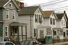
Houses north side of Trowbridge Square (1860s). | |
  | |
| Location | Roughly bounded by Columbus & Howard Aves., New Haven, Connecticut |
|---|---|
| Coordinates | 41°17′47″N 72°55′55″W / 41.29639°N 72.93194°WCoordinates: 41°17′47″N 72°55′55″W / 41.29639°N 72.93194°W |
| Area | 26 acres (11 ha) |
| Built | 1830 |
| Architect | Thompson,Isaac; Multiple |
| Architectural style | Greek Revival, Italianate, Queen Anne |
| NRHP Reference # | 85002311[1] |
| Added to NRHP | September 12, 1985 |
Trowbridge Square Historic District, originally known as Village of Spireworth and Mount Pleasant, is a 26-acre (11 ha) historic district in the Hill section New Haven, Connecticut.
It includes most of the area laid out by Jocelyn and Thompson in 1830 as the Village of Spireworth.[2]:44
The district was listed on the National Register of Historic Places in 1985. At that time it included 208 contributing buildings and one other contributing site.[1]
Its NRHP nomination asserted that the district was "historically significant as New Haven's most intact and cohesive surviving example of a working-class residential neighborhood which was planned and developed as such during the nineteenth century."[2]:29
Gallery
 Trowbridge Square towards the south side
 Houses west side of Trowbridge Square (1870s)
 Trowbridge Square towards the east side (1880s)
 South Congregational Church (1851), Liberty St. and Columbus Ave., Sidney Mason Stone. (Sacred Heart Church from 1875)
See also
References
- 1 2 National Park Service (2009-03-13). "National Register Information System". National Register of Historic Places. National Park Service.
- 1 2 Dorothea Penar; J. Paul Loether & John Herzan (March 1, 1985). "National Register of Historic Places Inventory-Nomination: Village of Spireworth/Mount Pleasant / Trowbridge Square Historic District" (PDF). National Park Service. and Accompanying 26 photos, from 1980 and 1985
| Topics | |
|---|---|
| Lists by states |
|
| Lists by insular areas | |
| Lists by associated states | |
| Other areas | |
| |
This article is issued from Wikipedia - version of the 11/29/2016. The text is available under the Creative Commons Attribution/Share Alike but additional terms may apply for the media files.