National Register of Historic Places listings in New Haven, Connecticut

This is a list of National Register of Historic Places listings in New Haven, Connecticut.
This is intended to be a complete list of the properties and districts on the National Register of Historic Places in the city of New Haven, Connecticut, United States. The locations of National Register properties and districts for which the latitude and longitude coordinates are included below, may be seen in a Google or Bing map.[1]
There are 260 properties and districts listed on the National Register in New Haven County. The city of New Haven is the location of 63 of these properties and districts, including 21 National Historic Landmarks; they are listed here, while the other properties and districts in the remaining parts of the county, including 1 National Historic Landmark, are covered in National Register of Historic Places listings in New Haven County, Connecticut. Two sites appear in both New Haven County lists.
- This National Park Service list is complete through NPS recent listings posted December 16, 2016.[2]
Current listings
| [3] | Name on the Register[4] | Image | Date listed[5] | Location | Neighborhood | Description |
|---|---|---|---|---|---|---|
| 1 | Ahavas Sholem Synagogue | 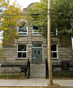 |
(#95000559) |
30 White St. 41°17′54″N 72°56′25″W / 41.298333°N 72.940278°W |
Hill | A former synagogue whose elaborate facade demonstrates "design effort directed, with considerable success, toward establishing a Jewish presence in the streetscape."[6] |
| 2 | M. Armstrong and Company Carriage Factory | 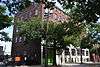 |
(#11000612) |
433 Chapel St. 41°18′13″N 72°54′44″W / 41.303611°N 72.912222°W |
New Haven | |
| 3 | Beaver Hills Historic District |  |
(#86002108) |
Roughly bounded by Crescent St., Goffe Terrace, and Boulevard 41°19′28″N 72°56′39″W / 41.324444°N 72.944167°W |
Beaver Hills | A neighborhood developed in early 1900s which is one of the first car-oriented neighborhoods around, and preserves Colonial Revival and other residential architecture.[7] |
| 4 | Beth Israel Synagogue | 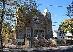 |
(#95000578) |
232 Orchard St. 41°17′54″N 72°56′25″W / 41.298333°N 72.940278°W |
West River | A Colonial Revival style building from 1925, designed by architect Louis Abramowitz for the orthodox synagogue.[8] |
| 5 | Elisha Blackman Building | 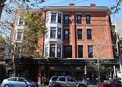 |
(#78002863) |
176 York St. 41°18′29″N 72°55′57″W / 41.308056°N 72.9325°W |
Downtown | Built in 1883 as an investment by a former carriage manufacturer, the building was the first commercial + rental building in a residential area, perhaps displeasing neighbors, though at least the design and workmanship is very fine.[9] |
| 6 | Chapel Street Historic District | 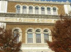 |
(#84001123) |
Roughly bounded by Park, Chapel, Temple, George, and Crown Sts. 41°18′20″N 72°55′47″W / 41.305556°N 72.929722°W |
Downtown and Dwight | A historic district representing the commercial development of New Haven in the late nineteenth and early twentieth centuries.[10] |
| 7 | Russell Henry Chittenden House | 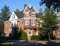 |
(#75001944) |
83 Trumbull St. 41°18′48″N 72°55′23″W / 41.313333°N 72.923056°W |
Prospect Hill | Home of Russell Henry Chittenden, the "father of American biochemistry", from 1887 to 1943.[11] The irregularly shaped three story house with Queen Anne elements was built in 1887 of brick, frame and shingling with gabled roof sections, gabled dormers, interior chimneys with corbeled caps, a square corner tower and a round-arched first-floor window.[12] |
| 8 | Christ Church New Haven | 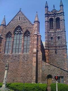 |
(#09000420) |
70 Broadway 41°18′44″N 72°55′56″W / 41.31225°N 72.932269°W |
Dixwell (in Broadway district) |
Episcopal parish church, begun as an offshoot from New Haven's Trinity Church, the central Episcopal church on New Haven's town green. Gothic building, completed in 1898, was designed by architect Henry Vaughan and includes a stone tower in style one at Oxford University in England.[13] |
| 9 | Connecticut Agricultural Experiment Station | 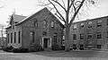 |
(#66000805) |
123 Huntington St. 41°19′51″N 72°55′10″W / 41.330833°N 72.919444°W |
Prospect Hill | Home of the first agricultural experiment station of any state that was started in 1875 in Middletown and moved to New Haven in 1877; its Osborne Library, built during 1882-83, is oldest building of any such station. Located at top of Prospect Hill, the station was center of early research on vitamins.[14] |
| 10 | Connecticut Hall, Yale University | 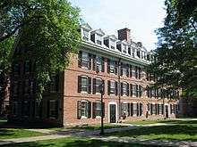 |
(#66000806) |
Bounded by High, Chapel, Elm, and College Sts. 41°18′29″N 72°55′46″W / 41.308056°N 72.929444°W |
Downtown | Georgian-style building from 1752 that is oldest Yale University building and only survivor of original Old Brick Row. Funded in part from the sale of a French ship. Gutted and rebuilt by after World War II.[15] |
| 11 | John Cook House | 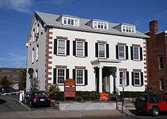 |
(#83003576) |
35 Elm St. 41°18′26″N 72°55′21″W / 41.307222°N 72.9225°W |
Downtown | One of the oldest stone buildings in New Haven, the house has unusual sandstone quoining and a ballroom on the 3rd floor. Adjacent to the 1828 Caroline Nicoll House.[16] |
| 12 | George W. Crawford House | Upload image | (#15000113) |
84-96 Park St. 41°18′24″N 72°56′07″W / 41.3066°N 72.9354°W |
||
| 13 | James Dwight Dana House | .jpg) |
(#66000874) |
24 Hillhouse Ave. 41°18′47″N 72°55′30″W / 41.313056°N 72.925°W |
Downtown | Home of Yale geologist, James Dwight Dana; designed by Henry Austin |
| 14 | Dwight Street Historic District |  |
(#83001281) |
Roughly bounded by Park, N. Frontage, Scranton, Sherman, and Elm Sts. 41°18′38″N 72°56′23″W / 41.310556°N 72.939722°W |
Dwight and West River | |
| 15 | East Rock Park | 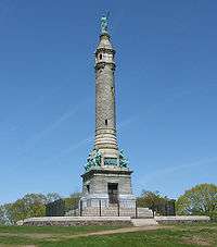 |
(#97000299) |
Roughly bounded by State, Davis, and Livingston Sts., Park and Mitchell Drs., and Whitney Ave. 41°19′41″N 72°54′21″W / 41.328056°N 72.905833°W |
East Rock and Hamden | Park designed by Frederick Law Olmsted |
| 16 | Edgerton | 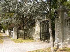 |
(#88001469) |
840 Whitney Ave. 41°20′04″N 72°54′52″W / 41.334361°N 72.914333°W |
Prospect Hill and into Hamden | A 20-acre (8.1 ha) public park, site of the home of Eli Whitney II. In 1909, it became the estate of Frederick F. Brewster, with a mansion constructed. The mansion was demolished in 1964. Designed landscape remains.[17]:4,6 |
| 17 | Edgewood Park Historic District | 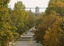 |
(#86001991) |
Roughly bounded by Whalley Ave. and Elm St., Sherman Ave. and Boulevard, Edgewood and Derby, and Yale Aves. 41°18′55″N 72°57′16″W / 41.315278°N 72.954444°W |
Edgewood, Westville, and West River[18] | |
| 18 | Farmington Canal-New Haven and Northampton Canal | 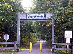 |
(#85002664) |
Roughly from Suffield in Hartford County to New Haven in New Haven County 41°19′26″N 72°55′51″W / 41.323889°N 72.930778°W |
Newhallville, Dixwell, and Downtown | Extends northward through Hamden and Cheshire (other towns in New Haven County) to Hartford County. Built as a canal, later became a railroad line, and now a multi-use trail. |
| 19 | Five Mile Point Lighthouse | 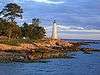 |
(#90001108) |
Lighthouse Point Park 41°14′56″N 72°54′14″W / 41.248889°N 72.903889°W |
East Shore | |
| 20 | Fort Nathan Hale | 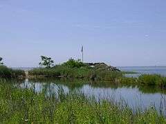 |
(#70000711) |
Southern end of Woodward Ave. 41°16′12″N 72°53′55″W / 41.27°N 72.898611°W |
East Shore | |
| 21 | Goffe Street Special School for Colored Children | 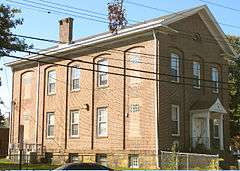 |
(#79002643) |
106 Goffe St. 41°18′56″N 72°56′06″W / 41.315556°N 72.935°W |
Dixwell | Permanent school that grew out of a meeting of New Haven citizens in 1864. New Haven architect Henry Austin donated the design. Used until 1874, after African-American children began attending previously all white public schools, then the building was used by African-American community organizations.[19] |
| 22 | Grove Street Cemetery | 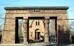 |
(#97000830) |
200 Grove St. 41°18′49″N 72°55′39″W / 41.313611°N 72.9275°W |
Downtown | Final resting place of many Yale and New Haven notables including Roger Sherman, Noah Webster and Eli Whitney. |
| 23 | Hall-Benedict Drug Company Building | 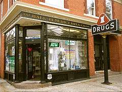 |
(#86001205) |
763-767 Orange St. 41°19′16″N 72°54′45″W / 41.321111°N 72.9125°W |
East Rock | |
| 24 | Hillhouse Avenue Historic District | 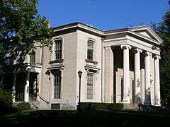 |
(#85002507) |
Bounded by Sachem, Temple, Trumbull, and Prospect Sts., Whitney and Hillhouse Aves., and railroad tracks 41°18′50″N 72°55′23″W / 41.313889°N 72.923056°W |
Prospect Hill and Downtown[20] | Historic street with landmark nineteenth century mansions. |
| 25 | Elizabeth R. Hooker House |  |
(#09000695) |
123 Edgehill Rd. 41°19′58″N 72°55′00″W / 41.332697°N 72.916717°W |
Prospect Hill | English style Arts and Crafts suburban villa designed by Delano & Aldrich and built in 1914 for Elizabeth R. Hooker. |
| 26 | Howard Avenue Historic District | 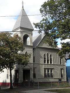 |
(#85002308) |
Properties along Howard Ave. between Interstate 95 and Cassius St. 41°17′31″N 72°55′59″W / 41.291944°N 72.933056°W |
Hill (including City Point) |
|
| 27 | Imperial Granum-Joseph Parker Buildings | 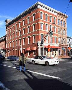 |
(#86000409) |
47 and 49-51 Elm St. 41°18′27″N 72°55′23″W / 41.3075°N 72.923056°W |
Downtown | |
| 28 | Lighthouse Point Carousel | 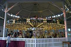 |
(#83003578) |
Lighthouse Point Park, Lighthouse Ave. 41°14′54″N 72°54′12″W / 41.248333°N 72.903333°W |
East Shore | |
| 29 | Lincoln Theatre | 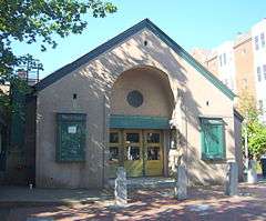 |
(#84001134) |
1 Lincoln St. 41°18′43″N 72°55′12″W / 41.311944°N 72.92°W |
Downtown | 1925 theatre with English free style facade |
| 30 | Othniel C. Marsh House | .jpg) |
(#66000875) |
360 Prospect St. 41°19′19″N 72°55′30″W / 41.321944°N 72.925°W |
Prospect Hill | Home of Yale paleontologist Othniel Charles Marsh; now part of the Yale School of Forestry. |
| 31 | Lafayette B. Mendel House | 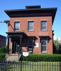 |
(#76002138) |
18 Trumbull St. 41°18′39″N 72°55′07″W / 41.310833°N 72.918611°W |
Downtown | Home of Yale biochemist Lafayette Mendel; designed by Henry Austin |
| 32 | Morris House |  |
(#72001341) |
325 Lighthouse Rd. 41°15′22″N 72°53′32″W / 41.256111°N 72.892222°W |
East Shore | |
| 33 | Mory's | 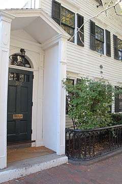 |
(#04001552) |
306 York St. 41°18′41″N 72°55′54″W / 41.311389°N 72.931667°W |
Dixwell (in Broadway district) |
|
| 34 | New Haven City Hall | 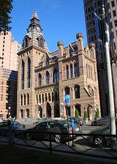 |
(#75001940) |
161 Church St. 41°18′26″N 72°55′29″W / 41.307222°N 72.924722°W |
Downtown | Victorian Gothic structure designed by Henry Austin |
| 35 | New Haven County Courthouse | 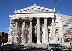 |
(#03000404) |
121 Elm St. 41°18′38″N 72°55′27″W / 41.310556°N 72.924167°W |
Downtown | Beaux Arts building from 1917, facing on New Haven Green, and containing "several of the city's grandest interior spaces". Site of Griswold v. Connecticut, a historic trial involving women's' right to birth control, and the trial of Black Panther Bobby Seale.[21] |
| 36 | New Haven Green Historic District | 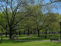 |
(#70000838) |
Bounded by Chapel, College, Elm, and Church Sts. 41°18′27″N 72°55′37″W / 41.3075°N 72.926944°W |
Downtown | Large town green includes three historic churches. |
| 37 | New Haven Jewish Home for the Aged | 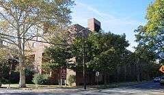 |
(#79002641) |
169 Davenport Ave. 41°18′09″N 72°56′23″W / 41.3025°N 72.939722°W |
Hill | |
| 38 | New Haven Lawn Club | 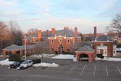 |
(#03000309) |
193 Whitney Ave. 41°18′57″N 72°55′10″W / 41.315833°N 72.919444°W |
East Rock | Colonial Revival designed by Douglas Orr |
| 39 | New Haven Railroad Station | 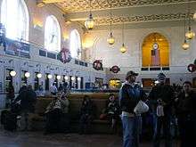 |
(#75001941) |
Union Ave. 41°17′51″N 72°55′37″W / 41.2975°N 72.926944°W |
Long Wharf | Beaux-arts station designed by Cass Gilbert |
| 40 | Caroline Nicoll House |  |
(#83001283) |
27 Elm St. 41°18′27″N 72°55′19″W / 41.3075°N 72.921861°W |
Downtown | Adjacent to the John Cook House |
| 41 | Ninth Square Historic District | 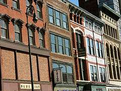 |
(#84001135) |
Roughly bounded by Church, State, George, and Court Sts. 41°18′17″N 72°55′28″W / 41.304722°N 72.924444°W |
Downtown | |
| 42 | Orange Street Historic District | 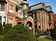 |
(#85002314) |
Roughly bounded by Whitney Ave., State, Eagle, and Trumbull Sts. 41°18′56″N 72°54′55″W / 41.315556°N 72.915278°W |
East Rock | |
| 43 | Oyster Point Historic District | 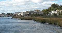 |
(#89001085) |
Roughly bounded by Interstate 95, S. Water St., Howard Ave., Sea St., and Greenwich Ave. 41°16′59″N 72°55′47″W / 41.283056°N 72.929722°W |
Hill (City Point section) |
|
| 44 | William Pinto House |  |
(#85002316) |
275 Orange St. 41°18′29″N 72°55′21″W / 41.308056°N 72.9225°W |
Downtown | |
| 45 | Plymouth Congregational Church |  |
(#83001250) |
1469 Chapel St. 41°18′41″N 72°56′40″W / 41.311389°N 72.944444°W |
Dwight | |
| 46 | Prospect Hill Historic District |  |
(#79002670) |
Area between Whitney Avenue and Winchester Avenue north of Edwards Street/Munson Street 41°19′30″N 72°55′15″W / 41.325°N 72.920833°W |
Prospect Hill and Dixwell[22] | Area of historic mansions and some institutional buildings |
| 47 | Quinnipiac Brewery | 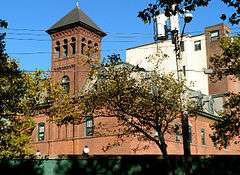 |
(#83001285) |
19-23 River St. 41°18′14″N 72°53′37″W / 41.303889°N 72.893611°W |
Fair Haven | |
| 48 | Quinnipiac River Historic District |  |
(#84001139) |
Roughly bounded by Quinnipiac Ave., Lexington, Chapel, Ferry, Pine, Front, and Lombard Sts. 41°18′35″N 72°52′59″W / 41.309722°N 72.883056°W |
Fair Haven and Fair Haven Heights | |
| 49 | Raynham | 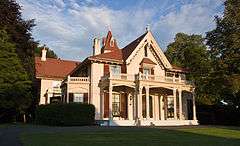 |
(#80004062) |
709 Townsend Ave. 41°16′34″N 72°53′42″W / 41.276111°N 72.895°W |
East Shore | |
| 50 | River Street Historic District |  |
(#88003213) |
Roughly bounded by Chapel St., Blatchley Ave., New Haven Harbor, and James St. 41°18′08″N 72°54′04″W / 41.302222°N 72.901111°W |
Fair Haven | |
| 51 | Southern New England Telephone Company Administrative Building | 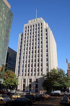 |
(#97001447) |
227 Church St. 41°18′33″N 72°55′25″W / 41.309167°N 72.923611°W |
Downtown | Art deco building designed by Douglas Orr |
| 52 | Southwest Ledge Lighthouse | 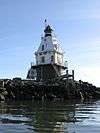 |
(#89001475) |
Southwestern end of the east breakwater at the entrance to New Haven Harbor 41°13′53″N 72°55′25″W / 41.231389°N 72.923611°W |
New Haven Harbor | Completed in 1877, this lighthouse with Second Empire style architecture above, was the first or one of the first built on a cylindrical iron foundation, an innovation to address shifting ice that is regarded as very important in lighthouse design. |
| 53 | St. Luke's Episcopal Church | 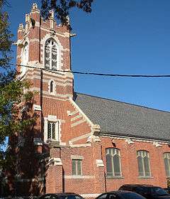 |
(#03001170) |
111-113 Whalley Ave. 41°18′51″N 72°56′09″W / 41.314167°N 72.935833°W |
Dixwell | |
| 54 | Strouse, Adler Company Corset Factory | 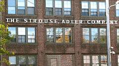 |
(#02000864) |
78-84 Olive St. 41°18′20″N 72°55′11″W / 41.305556°N 72.919722°W |
Wooster Square | A corset factory building |
| 55 | Trowbridge Square Historic District |  |
(#85002311) |
Roughly bounded by Columbus and Howard Aves. 41°17′47″N 72°55′55″W / 41.296389°N 72.931944°W |
Hill | |
| 56 | United States Post Office and Court House | 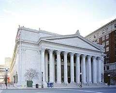 |
(#15000586) |
145 Church St. 41°18′24″N 72°55′30″W / 41.3066°N 72.9249°W |
||
| 56 | Upper State Street Historic District |  |
(#84001143) |
Roughly State St. from Bradley St. to Mill River St. 41°18′53″N 72°54′41″W / 41.314722°N 72.911389°W |
East Rock | |
| 57 | Welch Training School | 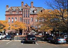 |
(#83001286) |
495 Congress Ave. 41°18′04″N 72°56′15″W / 41.301111°N 72.9375°W |
Hill | Queen Anne architecture applied to a commercial building, by Leoni W. Robinson |
| 58 | Westville Village Historic District | 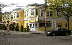 |
(#02001727) |
Roughly along Blake St. and Whalley Ave.; also 827 Whalley Ave. 41°19′38″N 72°57′32″W / 41.327222°N 72.958889°W |
Westville and West Rock[23] | Area of commercial buildings and more. 827 Whalley represents a boundary increase of October 25, 2006 |
| 59 | Whitney Avenue Historic District | 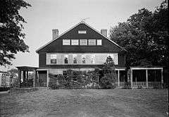 |
(#88003209) |
Roughly bounded by Burns St., Livingston St., Cold Spring St., Orange St., Bradley St., and Whitney Ave. 41°19′23″N 72°54′53″W / 41.323056°N 72.914722°W |
East Rock and Prospect Hill[24] | A middle- and upper-class residential neighborhood that showcases Queen Anne architecture, Shingle, Colonial Revival, Tudor Revival, and other architecture. |
| 60 | Winchester Repeating Arms Company Historic District | 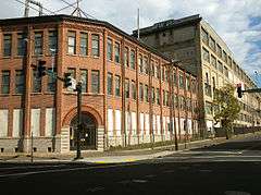 |
(#87002552) |
Roughly bounded by Hamden town line, Mansfield, Hazel & Division Sts., Winchester Ave., and Sherman Parkway 41°19′16″N 72°55′55″W / 41.321111°N 72.931944°W |
Newhallville and Dixwell | historic district including Leoni W. Robinson-designed buildings of the Winchester Repeating Arms Company and surrounding areas of single- and multi-family workers' houses. |
| 61 | Wooster Square Historic District | 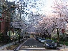 |
(#71000914) |
Roughly bounded by Columbus, Wooster Sq., Chapel St., and Court St. 41°18′16″N 72°55′05″W / 41.304444°N 72.918056°W |
Wooster Square | |
| 62 | Yale Bowl | 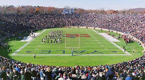 |
(#87000756) |
Southwest of the intersection of Chapel St. and Yale Ave. 41°18′46″N 72°57′39″W / 41.312778°N 72.960833°W |
Westville | Bowl stadium, model for the Rose Bowl and others. Home of the Bulldogs and The Game. |
Former listings
| [3] | Name on the Register | Image | Date listed | Date removed | Location | City or town | Summary |
|---|---|---|---|---|---|---|---|
| 1 | First Telephone Exchange | 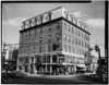 |
(#66000961) | 733 Chapel Street 41°18′16″N 72°55′17″W / 41.3045°N 72.9215°W |
New Haven | Former National Historic Landmark. Location of the First Telephone Exchange in the United States. Demolished in 1973 to make way for a parking garage.[25] |
See also
| Wikimedia Commons has media related to National Register of Historic Places in New Haven, Connecticut. |
- List of National Historic Landmarks in Connecticut
- National Register of Historic Places listings in Connecticut
References
- ↑ The latitude and longitude information provided in this table was derived originally from the National Register Information System, which has been found to be fairly accurate for about 99% of listings. For about 1% of NRIS original coordinates, experience has shown that one or both coordinates are typos or otherwise extremely far off; some corrections may have been made. A more subtle problem causes many locations to be off by up to 150 yards, depending on location in the country: most NRIS coordinates were derived from tracing out latitude and longitudes off of USGS topographical quadrant maps created under the North American Datum of 1927, which differs from the current, highly accurate WGS84 GPS system used by most on-line maps. Chicago is about right, but NRIS longitudes in Washington are higher by about 4.5 seconds, and are lower by about 2.0 seconds in Maine. Latitudes differ by about 1.0 second in Florida. Some locations in this table may have been corrected to current GPS standards.
- ↑ "National Register of Historic Places: Weekly List Actions". National Park Service, United States Department of the Interior. Retrieved on December 16, 2016.
- 1 2 Numbers represent an ordering by significant words. Various colorings, defined here, differentiate National Historic Landmarks and historic districts from other NRHP buildings, structures, sites or objects.
- ↑ National Park Service (2009-03-13). "National Register Information System". National Register of Historic Places. National Park Service.
- ↑ The eight-digit number below each date is the number assigned to each location in the National Register Information System database, which can be viewed by clicking the number.
- ↑ David F. Ransom (August 26, 1994). "National Register of Historic Places Multiple Property Listing, Historic Synagogues of Connecticut: Ahavas Sholem Synagogue / Thomas Chapel of the Church of Christ" (PDF). National Park Service. (pages 86-92 omitting page 89) and Accompanying two photos (apparently from 1994?)
- ↑ J. Paul Loether and John Herzan (January 14, 1986). "National Register of Historic Places Inventory-Nomination: Beaver Hills Historic District" (PDF). National Park Service. and Accompanying 27 photos, from 1984, 1986
- ↑ David F. Ransom (August 26, 1994). "National Register of Historic Places Multiple Property Listing, Historic Synagogues of Connecticut: Beth Israel" (PDF). National Park Service. (pages 72-85) and Accompanying four photos, exterior and interior
- ↑ David F. Ransom (June 19, 1978). "National Register of Historic Places Inventory-Nomination: Elisha Blackman Building / York-Chapel Building" (PDF). National Park Service. and Accompanying eight photos from 1978, exterior and interior, and a historic postcard view
- ↑ Kate Ohno and John Herzan (May 1983). "National Register of Historic Places Inventory-Nomination: Chapel Street Historic District" (PDF). National Park Service. and Accompanying 21 photos, exterior, from circa 1910, circa 1936, 1982, 1983 and other
- ↑ James Sheire (March 1975). "National Register of Historic Places Inventory-Nomination: Russell Henry Chittenden House / John C. Flanagan Law Office" (PDF). National Park Service. and Accompanying one photo, exterior, from 1975
- ↑ National Register of Historic Places Registration Form, Russell Henry Chittenden House, New Haven, Connecticut, National Register #75001944.
- ↑ "Christ Church, New Haven: Our history". Christ Church.
- ↑ S. Sydney Bradford and Blanche Higgins Schroer (January 2, 1975). "National Register of Historic Places Inventory-Nomination: Connecticut Agricultural Experiment Station" (PDF). National Park Service. and Accompanying four photos, exterior, from 1963 and 1974
- ↑ Blanche Higgins Schroer, Charles W. Snell, and S. Sydney Bradford (December 6, 1974). "National Register of Historic Places Inventory-Nomination: Connecticut Hall, Yale University" (PDF). National Park Service. and Accompanying photo from 1974 and etching from 1807/1910
- ↑ Jack A. Gold and Susan E. Ryan (March 1983). "National Register of Historic Places Inventory-Nomination: John Cook House" (PDF). National Park Service. and Accompanying 9 photos, exterior and interior, from 1980
- ↑ Janice L. Elliott and Marian Staye (March 10, 1988). "National Register of Historic Places Inventory-Nomination: Edgerton" (PDF). National Park Service. and Accompanying 17 photos from 1988, and 2 of mansion in 1960 and 1964 (captions on page 10 of text document)
- ↑ The portion of Edgewood Park west of the West River is officially included in the Westville neighborhood planning area. The West River Wildlife Sanctuary is officially part of the West River neighborhood planning area.
- ↑ Charles W. Brilvitch (November 1978). "National Register of Historic Places Inventory-Nomination: Goffe Street Special School for Colored Children / Prince Hall Grand Lodge of Masons" (PDF). National Park Service. and Accompanying four photos, exterior, from 1978
- ↑ Only one property is in the official Downtown neighborhood
- ↑ Heather L. McGrath and William G. Foulks (July 9, 2002). "National Register of Historic Places Registration: New Haven County Courthouse (including 20 photo copies)" (PDF). National Park Service. and Accompanying 13 photos, exterior and interior, from 2002
- ↑ Thirteen properties south of Hillside Place fronting Prospect street but on the west side are in the official Dixwell neighborhood
- ↑ Only one property is in the official West Rock neighborhood
- ↑ Properties along west side of Whitney Avenue are in the official Prospect Hill neighborhood
- ↑
| Lists by county |   | |
|---|---|---|
| Lists by city or town | ||
| Other lists | ||