The Rower
| The Rower an Robhar | |
|---|---|
| Town | |
|
Approaching The Rower from the south on the R705 | |
 The Rower Location in Ireland | |
| Coordinates: 52°27′22″N 6°57′25″W / 52.456°N 6.957°WCoordinates: 52°27′22″N 6°57′25″W / 52.456°N 6.957°W | |
| Country | Ireland |
| Province | Leinster |
| County | County Kilkenny |
| Time zone | WET (UTC+0) |
| • Summer (DST) | IST (WEST) (UTC-1) |
| Website |
www |
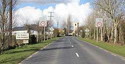
Rower or The Rower (from Irish: an Robhar) is a small village in County Kilkenny, Ireland. The Rower is on the R705 regional road, roughly 30 km from both Waterford and Kilkenny. It is within the parish of the same name, which is about five miles (8 km) in length from north to south, by about three miles in breadth.
It lies on the slopes of Brandon Hill and Cullintra Hill. It has a primary school, two churches, a GAA field and community hall. The ruined castle of Coolhill, said to have belonged to the Butler family, is nearby; and there are several broken dolmens in the vicinity of Ballinabarna.
They have a hurling team which competes in the Senior grade in Kilkenny.
History
Older spellings of the name include Roar, Rowar and Tamplerowar. Rower was a parish in the historical Barony of Ida. Within its limits was Ringwood, the seat of Lord Clifden, and an ancient residence of the Bolger family. The parish comprised 10,508 statute acres, as applotted under the tithe act, of which about 1,000 acres (4.0 km2) consist of mountain, and a small portion of bog.[1]
See also
Further reading
- Lewis, Samuel (1837). A Topgrahical Dictionary of Ireland. London: S. LEWIS & Co. 87, ALDERSGATE STREET.
Notes
- ↑ Lewis, Samuel. A topographical dictionary of Ireland, Vol. II, 1837. p540
External links
Places in County Kilkenny | ||
|---|---|---|
| Towns | 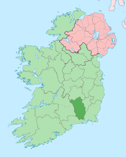 | |
| Villages |
| |
| Townlands | ||
| ||