Teterville, Kansas
| Teterville, Kansas | |
|---|---|
| Ghost Town | |
 Teterville | |
| Coordinates: 38°2′35″N 96°25′14″W / 38.04306°N 96.42056°WCoordinates: 38°2′35″N 96°25′14″W / 38.04306°N 96.42056°W[1] | |
| Country | United States |
| State | Kansas |
| County | Greenwood |
| Elevation[1] | 1,611 ft (491 m) |
| Population | |
| • Total | 0 |
| Time zone | CST (UTC-6) |
| • Summer (DST) | CDT (UTC-5) |
| GNIS feature ID | 0484837 [1] |
Teterville is a ghost town in Greenwood County, Kansas, United States.[1] It is located approximately 11 miles east of Cassoday. No buildings remain of this former community.
History
Teterville was founded as an "oil town" sometime after the Teeter Oil Field was discovered around 1920.[2] The oil field was named in honor of James Teter who owned about 6900 acres of land in Greenwood County.[3][4] A post office was opened in Teterville in 1927, and remained in operation until it was discontinued in 1962.[5]
Points of interest
- Teter Rocks. It is located 0.9 miles (1.4 km) south of Teterhill Road on top of a hill at 38°1′46.5″N 96°25′24.9″W / 38.029583°N 96.423583°W (38.029583, -96.423583). It is accessible by the public using a rural road on private land, so please respect the property. In 1954, the current monument was erected by the Greenwood County Historical Society to replace the earlier landmark created in the 1870s or 1880s by James Wesley Teter (1849-1929).[3][4][6][7]
See also
- Salem Township, Greenwood County, Kansas (location of Teterville)
- Teter, West Virginia (founded by relatives of James Teter)
Further reading
- My Flint Hills Childhood: Growing Up in 1930s Kansas; Gail Lee Martin; 186 pages; 2009.
References
- 1 2 3 4 Geographic Names Information System (GNIS) details for Teterville, Kansas; United States Geological Survey (USGS); October 13, 1978.
- ↑ Teeter-Scott Field - Oil and Gas Production.
- 1 2 Teterville Kansas, Teter Oil Fields, and Teter Rock.
- 1 2 Teterville and Teter Rock; kansastravel.org
- ↑ "Kansas Post Offices, 1828-1961, page 2 (archived)". Kansas Historical Society. Archived from the original on March 10, 2013. Retrieved 10 June 2014.
- ↑ James Teter biography
- ↑ James Wesley Teter at Find a Grave
External links
- Teterville, Teter Oil Fields, and Teter Rock
- Teterville and Teter Rock
- James Teter biography
- Greenwood County Maps: Current, 1954, 1936
Municipalities and communities of Greenwood County, Kansas, United States | ||
|---|---|---|
| Cities | 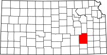 | |
| Unincorporated communities | ||
| Ghost towns | ||
| Townships | ||
This article is issued from Wikipedia - version of the 3/31/2016. The text is available under the Creative Commons Attribution/Share Alike but additional terms may apply for the media files.