Madison Township, Greenwood County, Kansas
| Madison Township | |
|---|---|
| Township | |
 Location in Greenwood County | |
| Coordinates: 38°06′55″N 096°12′46″W / 38.11528°N 96.21278°WCoordinates: 38°06′55″N 096°12′46″W / 38.11528°N 96.21278°W | |
| Country | United States |
| State | Kansas |
| County | Greenwood |
| Area | |
| • Total | 124.68 sq mi (322.91 km2) |
| • Land | 123.62 sq mi (320.17 km2) |
| • Water | 1.06 sq mi (2.74 km2) 0.85% |
| Elevation | 1,247 ft (380 m) |
| Population (2000) | |
| • Total | 1,155 |
| • Density | 9.3/sq mi (3.6/km2) |
| GNIS feature ID | 0477834 |
Madison Township is a township in Greenwood County, Kansas, USA. As of the 2000 census, its population was 1,155.
Geography
Madison Township covers an area of 124.68 square miles (322.9 km2) and contains one incorporated settlement, Madison. According to the USGS, it contains three cemeteries: Andrew, Blakely and Woods.
The streams of Bernard Branch, Holderman Creek, Kelly Branch, Moon Branch, North Branch Verdigris River, Rock Creek, South Branch Verdigris River and Tate Branch Creek run through this township.
Transportation
Madison Township contains one airport or landing strip, Godfrey Airport.
References
External links
Municipalities and communities of Greenwood County, Kansas, United States | ||
|---|---|---|
| Cities | 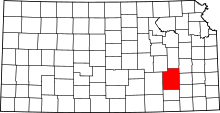 | |
| Unincorporated communities | ||
| Ghost towns | ||
| Townships | ||
This article is issued from Wikipedia - version of the 11/11/2013. The text is available under the Creative Commons Attribution/Share Alike but additional terms may apply for the media files.