Climax, Kansas
| Climax, Kansas | |
|---|---|
| City | |
 Location within Greenwood County and Kansas | |
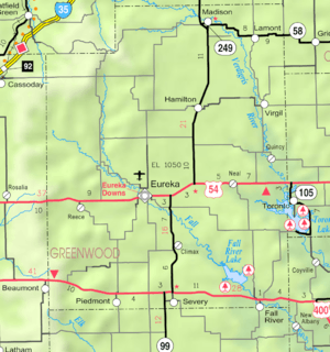 KDOT map of Greenwood County (legend) | |
| Coordinates: 37°43′13″N 96°13′26″W / 37.72028°N 96.22389°WCoordinates: 37°43′13″N 96°13′26″W / 37.72028°N 96.22389°W | |
| Country | United States |
| State | Kansas |
| County | Greenwood |
| Area[1] | |
| • Total | 0.12 sq mi (0.31 km2) |
| • Land | 0.12 sq mi (0.31 km2) |
| • Water | 0 sq mi (0 km2) |
| Elevation | 1,040 ft (317 m) |
| Population (2010)[2] | |
| • Total | 72 |
| • Estimate (2015)[3] | 68 |
| • Density | 600/sq mi (230/km2) |
| Time zone | Central (CST) (UTC-6) |
| • Summer (DST) | CDT (UTC-5) |
| ZIP code | 67137 |
| Area code | 620 |
| FIPS code | 20-14275 [4] |
| GNIS feature ID | 0474872 [5] |
Climax is a city in Greenwood County, Kansas, United States. As of the 2010 census, the city population was 72.[6]
History
Climax was founded in 1884.[7] It was named from its elevation,[8] or Climax College in Kalamazoo, Michigan.[9]
Geography
Climax is located at 37°43′13″N 96°13′26″W / 37.720155°N 96.223888°W (37.720155, -96.223888).[10] According to the United States Census Bureau, the city has a total area of 0.12 square miles (0.31 km2), all of it land.[1]
Demographics
| Historical population | |||
|---|---|---|---|
| Census | Pop. | %± | |
| 1930 | 129 | — | |
| 1940 | 157 | 21.7% | |
| 1950 | 91 | −42.0% | |
| 1960 | 81 | −11.0% | |
| 1970 | 64 | −21.0% | |
| 1980 | 81 | 26.6% | |
| 1990 | 57 | −29.6% | |
| 2000 | 64 | 12.3% | |
| 2010 | 72 | 12.5% | |
| Est. 2015 | 68 | [3] | −5.6% |
| U.S. Decennial Census | |||
2010 census
As of the census[2] of 2010, there were 72 people, 28 households, and 23 families residing in the city. The population density was 600.0 inhabitants per square mile (231.7/km2). There were 39 housing units at an average density of 325.0 per square mile (125.5/km2). The racial makeup of the city was 98.6% White and 1.4% from two or more races.
There were 28 households of which 28.6% had children under the age of 18 living with them, 71.4% were married couples living together, 3.6% had a female householder with no husband present, 7.1% had a male householder with no wife present, and 17.9% were non-families. 14.3% of all households were made up of individuals and 10.7% had someone living alone who was 65 years of age or older. The average household size was 2.57 and the average family size was 2.87.
The median age in the city was 48.5 years. 25% of residents were under the age of 18; 0.1% were between the ages of 18 and 24; 19.5% were from 25 to 44; 23.6% were from 45 to 64; and 31.9% were 65 years of age or older. The gender makeup of the city was 47.2% male and 52.8% female.
2000 census
As of the census[4] of 2000, there were 64 people, 24 households, and 18 families residing in the city. The population density was 509.3 people per square mile (190.1/km2). There were 29 housing units at an average density of 230.8 per square mile (86.1/km2). The racial makeup of the city was 85.94% White, 12.50% from other races, and 1.56% from two or more races. Hispanic or Latino of any race were 15.62% of the population.
There were 24 households out of which 33.3% had children under the age of 18 living with them, 66.7% were married couples living together, 4.2% had a female householder with no husband present, and 25.0% were non-families. 25.0% of all households were made up of individuals and 8.3% had someone living alone who was 65 years of age or older. The average household size was 2.67 and the average family size was 3.17.
In the city the population was spread out with 31.3% under the age of 18, 6.3% from 18 to 24, 21.9% from 25 to 44, 31.3% from 45 to 64, and 9.4% who were 65 years of age or older. The median age was 36 years. For every 100 females there were 113.3 males. For every 100 females age 18 and over, there were 120.0 males.
The median income for a household in the city was $34,375, and the median income for a family was $40,625. Males had a median income of $42,500 versus $14,375 for females. The per capita income for the city was $14,461. There were no families and 4.1% of the population living below the poverty line, including no under eighteens and 22.2% of those over 64.
See also
Further reading
References
- 1 2 "US Gazetteer files 2010". United States Census Bureau. Archived from the original on 2012-06-26. Retrieved 2012-07-06.
- 1 2 "American FactFinder". United States Census Bureau. Retrieved 2012-07-06.
- 1 2 "Annual Estimates of the Resident Population for Incorporated Places: April 1, 2010 to July 1, 2015". Retrieved July 2, 2016.
- 1 2 "American FactFinder". United States Census Bureau. Archived from the original on 2013-09-11. Retrieved 2008-01-31.
- ↑ "US Board on Geographic Names". United States Geological Survey. 2007-10-25. Retrieved 2008-01-31.
- ↑ "2010 City Population and Housing Occupancy Status". U.S. Census Bureau. Archived from the original on July 21, 2011. Retrieved March 6, 2011.
- ↑ "Greenwood County". Blue Skyways. Kansas State Library. Retrieved 10 June 2014.
- ↑ "Profile for Climax, Kansas". ePodunk. Retrieved 10 June 2014.
- ↑ Greenwood County Historical Society (Greenwood County, Kan.) (1986). The History of Greenwood County, Kansas (Vol 1), p. 27. Josten's Publications, Wichita, Kan.
- ↑ "US Gazetteer files: 2010, 2000, and 1990". United States Census Bureau. 2011-02-12. Retrieved 2011-04-23.
External links
| Wikimedia Commons has media related to Climax, Kansas. |
- City
- Schools
- USD 389, local school district
- Maps
- Climax City Map, KDOT
Municipalities and communities of Greenwood County, Kansas, United States | ||
|---|---|---|
| Cities | 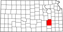 | |
| Unincorporated communities | ||
| Ghost towns | ||
| Townships | ||