Tennessee State Route 59
| ||||
|---|---|---|---|---|
| Route information | ||||
| Maintained by TDOT | ||||
| Major junctions | ||||
| West end: | Mississippi River near Randolph | |||
| East end: |
| |||
| Location | ||||
| Counties: | Tipton, Fayette, | |||
| Highway system | ||||
| ||||


State Route 59 is a state highway in Tennessee. It runs from the Mississippi River to just north of Somerville, Tennessee passing through Tipton and Fayette counties. It is a two-lane rural highway throughout its length and carries a 55 miles per hour (89 km/h) speed limit except when it passes through towns, in which case this speed limit can be significantly less.
Route description
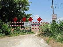
SR 59 begins at the Mississippi River in Tipton County in an area known as Richardson Landing. The route used to extend about 200 feet (61 m) further, but has since been eroded by the river, so much that barricades block the edge of the pavement to prevent motorists from driving into the river (See photo at left). As one continues east along the highway, one will notice that the elevation increases from around 250 to 400 feet (76 to 122 m) above sea level in less than 2 miles (3.2 km). This sharp increase is due to what is known as the second Chickasaw Bluff, a formation created by wind-blown silt which has accumulated from around the last Ice Age. At the top of this bluff is the small community of Randolph, which was important during the civil war and at one time was bigger than Memphis, Tennessee, 40 miles (64 km) down the river. One can witness spectacular views of the Mississippi River and Arkansas from the tops of the bluffs.
Continuing eastward from the bluffs, the road starts to level out into gently rolling farmland. SR 178 intersects SR 59 in the town of Gilt Edge, Tennessee. SR 59 also passes through Burlison, Tennessee before it crosses U.S. Highway 51 in downtown Covington.
SR 59 takes a southeast direction and crosses State Route 14 and joins US 70/US 79 in Mason, Tennessee. It is in this portion of the highway in which a wrong-way concurency occurs. SR 59 is traveling southwest, is signed as "East 59", while US 70 is signed as westbound and US 79 is signed as northbound. The same is true for motorists heading in the other direction.
SR 59 separates from the US highways in Braden, Tennessee and continues in a southeast direction. It crosses Interstate 40 south of Braden and is the terminus for both TN 194 and TN 222. The highway ends when it joins with TN 76 just a few miles north of Somerville.
SR 59 takes a southeast direction and crosses State Route 14 and joins US 70/US 79 in Mason, Tennessee. It is in this portion of the highway in which a wrong-way concurency occurs. SR 59 is traveling southwest, is signed as "East 59", while US 70 is signed as westbound and US 79 is signed as northbound. The same is true for motorists heading in the other direction.SR 59 separates from the US highways in Braden, Tennessee and continues in a southeast direction. It crosses Interstate 40 south of Braden and is the terminus for both TN 194 and TN 222. The highway ends when it joins with TN 76 just a few miles north of Somerville.
Major intersections
| County | Location | mi | km | Destinations | Notes |
|---|---|---|---|---|---|
| Tipton | | Dead end at Mississippi River | Western terminus of TN 59 | ||
| Gilt Edge | Northern terminus of TN 178 | ||||
| Covington | Eastern end of US 51/TN 3 concurrency | ||||
| Western terminus of TN 54 | |||||
| Southern end of US 51/TN 3 concurrency | |||||
| Western end of TN 384 concurrency | |||||
| Eastern end of TN 384 concurrency | |||||
| | |||||
| Mason | Eastern end of US 70/US 79/TN 1 | ||||
| Fayette | Braden | Western end of US 70/US 79/TN 1 | |||
| | |||||
| | Northern terminus of TN 194 | ||||
| | Southern terminus of TN 222 | ||||
| | Eastern terminus of TN 59 | ||||
1.000 mi = 1.609 km; 1.000 km = 0.621 mi
| |||||