Chickasaw Bluff
The Chickasaw Bluff is the high ground rising about 50 to 200 feet (20–60 m) above the flood plain between Fulton in Lauderdale County, Tennessee and Memphis in Shelby County, Tennessee.[1][2] This elevation is named for the Chickasaw, who by their possession of the elevation impeded French river traffic in the 18th Century.
Location
The Chickasaw Bluffs were numbered by rivermen from one to four starting from the north.[2]
| Bluff | Location (north to south) | County | Coordinates (approx.)[3] |
|---|---|---|---|
| First | Above Fulton | Lauderdale | 35°37′26″N 89°52′12″W / 35.624°N 89.870°W |
| Second | At Randolph | Tipton | 35°30′58″N 89°53′17″W / 35.516°N 89.888°W |
| Third | Meeman-Shelby Forest State Park | Tipton and Shelby | 35°22′16″N 90°03′54″W / 35.371°N 90.065°W |
| Fourth | Below the mouth of the Wolf River at Memphis | Shelby | 35°08′28″N 90°03′18″W / 35.141°N 90.055°W |
Geology
The Chickasaw Bluffs are a relatively recent feature. They were formed from pleistocene loess (wind-blown) silt. This loess can be as thick as 70 feet and it generally tapers off as one moves eastward. The loess accumulated on top of fluvial deposits from the pliocene. These primarily consist of terrace gravels deposited from glacial runoff. Because of this, the bluffs are slide-prone, especially during seismic activity.[1] The bluffs are characterized by very steep valleys and have higher gradient streams than areas to the east or west. Along the western edges facing the river or alluvial plains, they bluffs form nearly vertical cliffs. In Memphis, these edges have been smoothed out in the downtown area.
Although the Chickasaw Bluffs refer to the four numbered formations in Tennessee, the geological feature stretches from Hickman, Kentucky to around Baton Rouge, Louisiana. They do not form a continuous band, as they are split by river valleys such as the Obion River, Forked Deer River, Hatchie River, Loosahatchie River, Wolf River, Coldwater River, and Tallahatchie River.
It is theorized that Crowley's Ridge in Arkansas was part of the Chickasaw Bluff formation before the previous ice age when the prehistoric courses of the Ohio River and Mississippi River carved a path between the two. Crowley's Ridge has the same composition as the Chickasaw Bluffs and has similar topography.
Human History
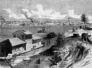
The fourth Chickasaw Bluff was the site of the French Fort Assumption, used as a base against the Chickasaw in the abortive Campaign of 1739. The Chickasaw Bluff secured Memphis from river floods, while a rare shelf of sandstone below provided a secure boat landing, making this the "only site for a commercial mart" between the Ohio River and Vicksburg, Mississippi.[4] This location was also the meeting place of d'Artaguette, Chicagou and de Vincennes before their ill fated 1736 attack against the Chickasaw.
Fort Prudhomme

The French Fort Prudhomme, or Prud'homme, was established at one of the Chickasaw Bluffs in 1682. René-Robert Cavelier, Sieur de La Salle (1643–87) was a French explorer. In 1682, La Salle led a canoe expedition to explore the Mississippi River basin. The expedition landed to hunt, when one of their members went missing. The armorer Pierre Prudhomme was assumed captured by Chickasaw Indians. La Salle decided to stay and search for the missing member. La Salle had a stockade built and named it Fort Prudhomme, after their lost man. This was the first structure built by the French in Tennessee. Days later, the missing member found his way back.[5] Prudhomme had lost his way while hunting.[6] The expedition reached the mouth of the Mississippi River on April 6, 1682.[5]
The exact location of Fort Prudhomme is unknown. Researchers agree that it was located on the Chickasaw Bluffs but it is disputed on which of the four bluffs the fortification was located. Some historians claim that Fort Prudhomme was built on the first Chickasaw Bluff, in modern day Lauderdale County.[7][8] The Tennessee Encyclopedia of History and Culture suggests that the fort was constructed on the second Chickasaw Bluff near modern day Randolph.[5][9] Other research mentions the third Chickasaw Bluff as the location of the fort, at the border of modern Tipton and Shelby Counties.[6][10] Again other sources assume that the fourth Chickasaw Bluff in modern Shelby County at Memphis was the location of Fort Prudhomme.[11][12]
See also
References
| Wikimedia Commons has media related to Chickasaw Bluff. |
- 1 2 Knox, Ray (1995). The New Madrid Fault Finders Guide. Gutenberg Richter Publications. p. 57. ISBN 978-0-934426-42-8.
- 1 2 Safford, James (1869). The Geology of Tennessee. S. C. Mercer, Nashville. pp. 112–113. OCLC 01448824.
- ↑ "Google Maps". Google.com. Retrieved 2009-02-19.
- ↑ Pierson, Uriah (1873). James' River Guide. U. P. James, Cincinnati. pp. 33–36. OCLC 05153739.
- 1 2 3 Magness, Perre (1998). "TN Encyclopedia: Fort Prudhomme and La Salle". The Tennessee Encyclopedia of History and Culture. Retrieved 12 January 2009.
- 1 2 Parkman, Francis; Levin, David (1983). France and England in North America. Library of America. p. 921. ISBN 0-940450-10-0.
- ↑ Tennessee: A Guide to the State. US History Publishers. 1978 [1939]. p. 422. ISBN 1-60354-041-5.
- ↑ Conard, Howard Louis (1901). Encyclopedia of the History of Missouri: A Compendium of History and Biography for Ready Reference. The Southern History Company, Haldeman, Conard & Co., Proprietors. p. 492.
- ↑ "Mississippi River Corridor - Historical and Cultural Amenities". Mississippi River Corridor, Tennessee. 2008. Retrieved 12 January 2009.
- ↑ Kellogg, Louise Phelps (1917). Early Narratives of the Northwest, 1634-1699. New York, N.Y.: C. Scribner's Sons. p. 297.
- ↑ "Encyclopedia.com - Tennessee Information - The Columbia Encyclopedia, Sixth Edition". Columbia University Press. 2008. Retrieved 12 January 2009.
- ↑ Phelan, James (1888). History of Tennessee: The Making of a State. Boston, Massachusetts: Houghton, Mifflin and Company. pp. 307–308, 313.