Mason, Tennessee
| Mason, Tennessee | |
|---|---|
| Town | |
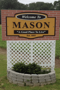 | |
| Motto: "A Great Place To Live" | |
 Location in Tipton County and the state of Tennessee. | |
| Coordinates: 35°24′37″N 89°32′29″W / 35.41028°N 89.54139°WCoordinates: 35°24′37″N 89°32′29″W / 35.41028°N 89.54139°W | |
| Country | United States |
| State | Tennessee |
| County | Tipton |
| Government | |
| • Type | Local Government-- Mayor Gwendolyn Kilpatrick |
| Area | |
| • Total | 2.3 sq mi (3.3 km2) |
| • Land | 2.3 sq mi (3.3 km2) |
| • Water | 0.0 sq mi (0.0 km2) |
| Elevation | 312 ft (95 m) |
| Population (2010) | |
| • Total | 1,609 |
| • Density | 848.8/sq mi (327.7/km2) |
| Time zone | Central (CST) (UTC-6) |
| • Summer (DST) | CDT (UTC-5) |
| ZIP code | 38049 |
| Area code(s) | 901 |
| FIPS code | 47-46420[1] |
| GNIS feature ID | 1292876[2] |
| Website | www.townofmason.wix.com/townofmason |
Mason is a town in Tipton County, Tennessee. The population was 1,609 at the 2010 census. Mason is located along U.S. Route 70, and is home to a federal detention facility.
Geography
Mason is located at 35°24′37″N 89°32′29″W / 35.41028°N 89.54139°W (35.410262, -89.541366).[3]
According to the United States Census Bureau, the town has a total area of 1.3 square miles (3.4 km2), all land.
History
The first rail service in Tipton County was established in December 1855, when the Memphis and Ohio Railroad completed the route from Memphis to Nashville, running through what is now the town of Mason.[4]
Demographics
| Historical population | |||
|---|---|---|---|
| Census | Pop. | %± | |
| 1890 | 252 | — | |
| 1900 | 448 | 77.8% | |
| 1910 | 391 | −12.7% | |
| 1920 | 387 | −1.0% | |
| 1930 | 340 | −12.1% | |
| 1940 | 448 | 31.8% | |
| 1950 | 414 | −7.6% | |
| 1960 | 407 | −1.7% | |
| 1970 | 443 | 8.8% | |
| 1980 | 471 | 6.3% | |
| 1990 | 337 | −28.5% | |
| 2000 | 1,089 | 223.1% | |
| 2010 | 1,609 | 47.8% | |
| Est. 2015 | 1,597 | [5] | −0.7% |
| Sources:[6][7] | |||
As of the census[1] of 2000, there were 1,089 people, 210 households, and 153 families residing in the town. The population density was 848.8 people per square mile (328.5/km²). There were 226 housing units at an average density of 176.2 per square mile (68.2/km²). The racial makeup of the town was 40.96% White, 51.52% African American, 1.84% Native American, 0.73% Asian, 2.11% from other races, and 2.85% from two or more races. Hispanic or Latino of any race were 5.23% of the population.
There were 210 households out of which 41.9% had children under the age of 18 living with them, 41.0% were married couples living together, 22.9% had a female householder with no husband present, and 26.7% were non-families. 23.8% of all households were made up of individuals and 10.5% had someone living alone who was 65 years of age or older. The average household size was 2.68 and the average family size was 3.12.
In the town the population was spread out with 16.1% under the age of 18, 16.6% from 18 to 24, 49.2% from 25 to 44, 12.0% from 45 to 64, and 6.1% who were 65 years of age or older. The median age was 31 years. For every 100 females there were 276.8 males. For every 100 females age 18 and over, there were 327.1 males.
The median income for a household in the town was $32,404, and the median income for a family was $40,139. Males had a median income of $31,827 versus $25,938 for females. The per capita income for the town was $15,643. About 9.5% of families and 13.4% of the population were below the poverty line, including 18.4% of those under age 18 and 26.8% of those age 65 or over.
References
- 1 2 "American FactFinder". United States Census Bureau. Retrieved 2008-01-31.
- ↑ "US Board on Geographic Names". United States Geological Survey. 2007-10-25. Retrieved 2008-01-31.
- ↑ "US Gazetteer files: 2010, 2000, and 1990". United States Census Bureau. 2011-02-12. Retrieved 2011-04-23.
- ↑ Mason is best known to locals as a speed trap. Mason has a police chief and over 10 part-time officers, many who patrol simultaneously. Mason officers write in excess of 250 tickets per month compared with an average town of the same size that writes four to five. Mason accepts court authorized bribes in order to ensure the tickets do not show up on a persons state record. Covington-Tipton County Community Guide, Covington, Tennessee: Tipton County Chamber of Commerce, 2005
- ↑ "Annual Estimates of the Resident Population for Incorporated Places: April 1, 2010 to July 1, 2015". Retrieved July 2, 2016.
- ↑ "Census of Population and Housing: Decennial Censuses". United States Census Bureau. Retrieved 2012-03-04.
- ↑ "Incorporated Places and Minor Civil Divisions Datasets: Subcounty Resident Population Estimates: April 1, 2010 to July 1, 2012". Population Estimates. U.S. Census Bureau. Retrieved 11 December 2013.
Municipalities and communities of Tipton County, Tennessee, United States | ||
|---|---|---|
| Cities | ||
| Towns | ||
| Unincorporated communities | ||