Tavares Seaplane Base
| Tavares Seaplane Base | |||||||||||
|---|---|---|---|---|---|---|---|---|---|---|---|
| IATA: none – ICAO: none – FAA LID: FA1 | |||||||||||
| Summary | |||||||||||
| Airport type | Public | ||||||||||
| Owner | City of Tavares | ||||||||||
| Serves | Tavares, Florida | ||||||||||
| Elevation AMSL | 63 ft / 19 m | ||||||||||
| Coordinates | 28°47′43″N 081°43′16″W / 28.79528°N 81.72111°W | ||||||||||
| Website | www.tavares.org/... | ||||||||||
| Runways | |||||||||||
| |||||||||||
Tavares Seaplane Base[2] (FAA LID: FA1) is a city-owned, public-use seaplane base located one nautical mile (1.85 km) southeast of the central business district of Tavares,[1] a city in Lake County, Florida, United States.
Facilities
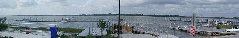
Panorama of the Tavares Seaplane Base & Marina on Lake Dora
Tavares Seaplane Base covers an area of 50 acres (20 ha) at an elevation of 63 feet (19 m) above mean sea level. The seaplane landing area on Lake Dora is designated 9/27 and measures 3,000 by 200 feet (914 x 61 m).[1][3]
References
- 1 2 3 FAA Airport Master Record for FA1 (Form 5010 PDF). Federal Aviation Administration. Effective 3 June 2010.
- ↑ Show, Christine (November 22, 2008). "Tavares keeps it simple in naming seaplane base". Orlando Sentinel.
- ↑ "Aerial image of Lake Dora showing seaplane landing area" (PDF).
External links
- Tavares Seaplane Base & Marina
- Aerial image as of 25 January 1999 from USGS The National Map
- Resources for this airport:
- FAA airport information for FA1
- AirNav airport information for FA1
- FlightAware airport information and live flight tracker
- SkyVector aeronautical chart for FA1
This article is issued from Wikipedia - version of the 11/17/2016. The text is available under the Creative Commons Attribution/Share Alike but additional terms may apply for the media files.