Naval Air Station Ellyson Field
Coordinates: 30°31′40″N 87°11′51″W / 30.52770°N 87.19753°W
| Naval Air Station Ellyson Field | |
|---|---|
 | |
| IATA: none – ICAO: none | |
| Summary | |
| Opened | 1940 |
| Closed | 1973 |
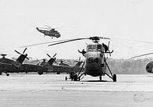
[[File:|thumb|H-34 helicopters of HT-8 at Ellyson Field, in 1967.]]
Naval Air Station Ellyson Field was a former U.S. Navy training base, established in Escambia County, Florida in 1940 at the outset of World War II as an auxiliary facility to Chevalier Field at Naval Air Station Pensacola, Florida. Originally designated Base Field 01913 (Site 3), located on the west side of Escambia Bay 16 miles northeast of NAS Pensacola, construction on an expanded facility, officially named Ellyson Field in honor of CDR Theodore G. “Spuds” Ellyson, the Navy’s first aviator, began on 26 February 1941. It had eight paved runways and three hangars.
It last served the Navy as a helicopter training facility through December 1973, by which time conflicts with air traffic patterns for what is now known as Pensacola International Airport, located just south of the station, coupled with the reorganization of Naval Air Training Command, led to a decision to close the field. Helicopter training was moved to NAS Whiting Field, Florida, and flight operations were discontinued on 28 December 1973.
The base was declared a non-aviation activity and claimed by the Naval Education and Training Program Development Center. Following the training centere's move to Saufley Field, Florida, in 1979, Ellyson was declared excess and the gates were permanently closed.
It is now a civilian industrial park with only a few of the Navy buildings still standing. These include the operations building, the three hangars, the academic training building, the dispensary and the Bachelor Officers Quarters (BOQ) that served the Navy, Marine Corps, Coast Guard and NATO/Allied officer flight student personnel assigned to Ellyson for rotary-wing training. Portions of the ramp areas also still exist but the runway grid has been completely redeveloped.