Tasman National Park
| Tasman National Park Tasmania | |
|---|---|
|
IUCN category II (national park) | |
 Sunrise at Fortescue Bay | |
 Tasman National Park | |
| Nearest town or city | Port Arthur |
| Coordinates | 42°51′19″S 147°58′33″E / 42.85528°S 147.97583°ECoordinates: 42°51′19″S 147°58′33″E / 42.85528°S 147.97583°E |
| Established | 30 April 1999[1] |
| Area | 107.5 km2 (41.5 sq mi)[1] |
| Managing authorities | Tasmania Parks and Wildlife Service |
| Website | Tasman National Park |
| See also | Protected areas of Tasmania |
The Tasman National Park is a national park that is located in eastern Tasmania, Australia, approximately 56 kilometres (35 mi) east of Hobart. The 107.5-square-kilometre (41.5 sq mi) park is situated on part of both the Forestier and Tasman peninsulas and encompasses all of Tasman Island.
History

The park was proclaimed under the Regional Forest Agreement on 30 April 1999.[2] The Tasman Island Lighthouse (constructed in 1906) is located on Tasman Island, which is part of the park. This lighthouse and weather station has been unmanned since 1977.[3][4]
Geography
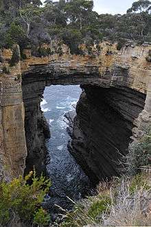
At 300 metres (980 ft) above sea level, the columnar dolerite cliffs at Cape Pillar and Tasman Island are among the highest in the world.[2] Dolerite is a rare rock type on mainland Australia.[2] Land formations accessible by road include the Blowhole (a hole at the inland end of a sea cave), Devils Kitchen (a rock hole) and Waterfall Bay.[2] Dolerite formations which are more easily viewed from the ocean include Cathedral Rock, Totem Pole, Candlestick, and Tasmans Arch. The park includes The Lanterns, three small islands.
Flora
Three species of Euphrasia (a semi-parasitic, herbaceous flowering plant commonly known as eyebright) are found only in Tasman National Park.[2] The rare Cape Pillar Sheoak is a shrub or small tree found only in the Tasman National Park where it is restricted to the Cape Pillar area of the Tasman Peninsula and to Tasman Island.[5]
Fauna
Australian fur seals use the coastline for breeding and resting, and little penguins (sometimes referred to as "blue penguins" or "fairy penguins") nest along the foreshore.[2]
The park forms part of the South-east Tasmania Important Bird Area, identified as such by BirdLife International because of its importance in the conservation of a range of woodland birds, especially the endangered swift parrot and forty-spotted pardalote.[6]
Three Capes track
The Three Capes track is a proposed 68-kilometre (42 mi), 5 night/6 day, hut based, one way walk encompassing the three capes in the Tasman National Park: Cape Hauy, Cape Pillar and Cape Raoul.[7] The proposal would require an additional 30 kilometres (19 mi) of additional walking track, and upgrades to existing track.[7] The proposal suggests that the infrastructure would be required to cater for 60 walkers each day. The feasibility study proposed a fee of A$200.[7] The track would start at White Beach and end at Fortesque Bay.[7]
The Three Capes Track is a one-way 46km 3 night track in Tasman National Park opened on December 25 2015. It starts at Port Arthur Historic Sites and ends at Fortescue Bay with a bus taking the walkers back to Port Arthur Historic Sites. The walkers arrive at the jetty at Port Arthur Historic Sites, are taken by boat around the bay of Port Arthur then left at Denmans Cove. From there they trek 46km to Fortescue Bay over 3 nights, stopping each night at a hut that provides water, gas top cookers, toilets and sleeping. Each hut has one Tasmanian Parks and Wildlife Ranger as well as a roving ranger who goes between huts. The huts can accomedate 48 people per night and as of December 2016 has had 8000 participants. The 4 day walk goes to Cape Pillar, Cape Hauy, Mount Fortescue, Arthurs Peak, Ellarwey Valley and ends at Fortescue Bay. The total cost was 25 million AUD including 18000 helicopter flights to the site. Before the new track was created there was already an older and not maintained track that was first created in 1990, with the Three Capes Track first being attempted to be made in the mid to late 1960s' by members of the Hobart Walkers Club.
See also
References
| Wikimedia Commons has media related to Tasman National Park. |
- 1 2 "Reserve Listing - National Parks". Tasmanian Parks and Wildlife Service Website. Tasmania Parks and Wildlife Service. 17 November 2008. Retrieved 1 May 2010.
- 1 2 3 4 5 6 "Tasman National Park - Highlights". Parks & Wildlife Service Tasmania. Retrieved 23 July 2009.
- ↑ Brothers, Nigel; Pemberton, David; Pryor, Helen; & Halley, Vanessa. (2001). Tasmania’s Offshore Islands: seabirds and other natural features. Tasmanian Museum and Art Gallery: Hobart. ISBN 0-7246-4816-X
- ↑ "Tasman Island Lighthouse". Lighthouses of Tasmania. Lighthouses of Australia Inc.
- ↑ "Allocasuarina crassa" (PDF). Threatened Flora of Tasmania. Department of Primary Industries and Water, Tasmania. Retrieved 2011-11-03.
- ↑ "IBA: South-east Tasmania". Birdata. Birds Australia. Retrieved 2011-10-13.
- 1 2 3 4 "Three Capes Track Proposal". Department of Environment, Parks, Heritage and the Arts. June 2009. Archived from the original on 23 July 2009. Retrieved 2009-07-23.
South Eastern region of Tasmania, Australia | |||||||
|---|---|---|---|---|---|---|---|
| Governance former | |||||||
| Mountains |
| ||||||
| Protected areas, parks and reserves |
| ||||||
| Rivers | |||||||
| Harbours, bays, inlets and estuaries | |||||||
| Transport | |||||||
| Landmarks |
| ||||||
| Islands |
| ||||||
| Books and newspapers | |||||||
| Bioregions | |||||||
| |||||||