Sylhet Division
| Sylhet Division সিলেট বিভাগ | ||
|---|---|---|
| Division of Bangladesh | ||
| ||
 Map of Sylhet Division | ||
| Coordinates: 24°30′N 91°40′E / 24.500°N 91.667°ECoordinates: 24°30′N 91°40′E / 24.500°N 91.667°E | ||
| Country |
| |
| Capital | Sylhet | |
| Area | ||
| • Total | 12,298.4 km2 (4,748.4 sq mi) | |
| Population (2011 census) | ||
| • Total | 9,910,219 | |
| • Density | 810/km2 (2,100/sq mi) | |
| Demographics | ||
| • Languages | Sylheti, Standard Bengali | |
| • Literacy rate | 39.18%[1] | |
| Time zone | BST (UTC+6) | |
| ISO 3166 code | BD-G | |
| Website |
sylhetdiv | |
Sylhet Division (Bengali: সিলেট বিভাগ, Silet Bibhag), also known as Greater Sylhet or Sylhet region,[2] is the northeastern division of Bangladesh, named after its main city, Sylhet. It is bordered by the Meghalaya, Assam and Tripura states of India to the north, east and south, respectively; and by the Bangladesh divisions of Chittagong to the southwest and Dhaka to the west.
Sylhet is considered one of the most picturesque and archaeologically rich regions in South Asia, and has major Islamic Sufi shrines and Hindu holy sites. Its bourgeoning economy has contributed to the regional attractions of landscapes filled with fragrant orange and pineapple gardens and tea plantations. Many Sylheti community members are working and residing abroad, particularly in the United Kingdom. They send remittances to fund projects and industries within the Sylhet Division, which have led to the expansion of the export industry and foreign investment sectors.
History
Historians believe that Sylhet was an expanded commercial centre since the ancient period, which explains its original namesake. During this time, Sylhet was probably inhabited by Indo-Aryan Brahmins, though ethnically the population would also included Mongoloids, Dravidians of Bengal, Arabs, Persians and Turks. It has also been suggested that the Ancient Kingdom of Harikela was situated in modern Sylhet.[3][4]
The 14th century marked the beginning of Islamic influence in Sylhet.[5] During the medieval period, Sylhet was a leading centre of Persian-speaking Muslim missionaries.[6]
A Muslim saint, Hazrat Shaikh al Mushaek Jalal Uddin, popularly known as Shah Jalal, arrived in Sylhet in 1303 CE from Mecca via Delhi, together with 360 companions and army generals such as Sikander Ghazi, Syed Nasiruddin and Khwaja Burhanuddin Qahafan, who defeated Govinda of Gaur.[7] Sikander Ghazi was the nephew of Sultan Feroze Shah of Delhi. Under the spiritual leadership of Hazrat Shah Jalal and his 360 companions, the Muslims converted many local Hindus. He died in Sylhet in or around the year 1350 CE. His shrine is located inside the parameter of the mosque complex known as Dargah-e-Shah Jalal.
Shah Jalal remains revered; visitors arrive from all over Bangladesh and beyond to pay homage.[7] Saint Shah Jalal and his companions are credited with converting most of the populace from their earlier beliefs in Hinduism, Buddhism and other religions to Islam. By the 15th century, Sylhet became a centre of the Assam and Bangla languages. In the official documents and historical papers, Sylhet was often referred to as Jalalabad during the era of the Muslim rule.[8][9]
Sylhet is an important center of historical significance to Hindus. Sylhet is home to two of the fifty-one body parts of Sati, a form of Goddess Durga, that fell on Earth according to accepted legends. Shri Shail in Jainpur village near Gotatikar in south Surma and Jayanti at Kalajore Baurbhag village of Jaintia are where the neck and left palm of Sati fell on this Earth. In addition, the 16th century Krishna Chaitanya's's ancestral homes are in Golapganj and Habiganj. Hindus believe Chaitanya was a reincarnation of Krishna and will return during the kalijug or end of time.
In the late 18th century, the British East India Company became interested in Sylhet and saw it as an area of strategic importance in the war against Burma. The British gradually absorbed Sylhet under their control, and governed it as a part of Bengal. After the British administrative reorganization of India, Sylhet was incorporated into Assam. It remained a part of Assam for the rest of the era of British rule.
In 1947, following a referendum and the Partition of India, almost all of erstwhile Sylhet became a part of East Pakistan, barring the Karimganj subdivision, which was incorporated into the new Indian state of Assam.[10] The referendum was held on 3 July 1947, there were a total of 546,815 votes cast on 239 polling stations, a majority of 43.8 per cent voted in favour of East Bengal. There were protests regarding bogus votes. The referendum was acknowledged during India's independence celebration on 18 July 1947.[11] In 1971, Sylhet became part of the newly formed independent country of Bangladesh.[8]
The Sylhet region has a "friendship link" with the city of St Albans, in the United Kingdom. The link was established in 1988 when the St Albans District Council supported a housing project in Sylhet as part of the International Year of Shelter for the Homeless. Sylhet was chosen because it is the area of origin for the largest ethnic minority group in St Albans.[12]
According to the St. Albans District Council: the majority of British Bangladeshis are of Sylheti ethnic origin. It is a testament of Sylhet in its history of trade relations with other parts of the world.
Economy
The area around Sylhet is a traditional tea growing area. The Surma Valley is covered with terraces of tea gardens and tropical forests. Srimangal is known as the tea capital of Bangladesh; for miles around, tea gardens are visible on the hill slopes.
The area has over 150 tea gardens, including three of the largest tea plantations in the world, both in terms of area and production. Nearly 300,000 workers, of which more than 75% are women, are employed on the tea estates. Employers prefer to engage women for plucking tea leaves since they do a better job than, but are paid less than, men. A recent drought has killed nearly a tenth of the tea shrubs.

The plantations, or gardens, were mostly developed during the British Raj. The plantations were started by the British, and the managers still live in the white timber houses built during the Raj. The bungalows stand on huge lawns. The service and the lifestyle of managers are still unchanged.
Numerous projects and businesses in the city and in large towns have been funded by Sylhetis living and working abroad. More than 95 percent of the ethnic British Bangladeshis originated or had ancestors from this Sylhet region.[13] The Bangladesh government has set up a special Export Processing Zone (EPZ) in Sylhet, in order to attract foreign investors, mainly from the UK.
Arts and culture
Many Sylheti try to marry spouses within the same regional, cultural, social and religious backgrounds.[14] Sylheti people are considered a distinct ethnic group in Bangladesh;[15] They are generally family oriented, follow and support Sylheti community culture, and are more conformist Muslims. These tendencies have led to some rivalry between non-Sylhetis and Sylhetis, due to differences in customs.[16]
Marriages are practiced in a traditional Muslim style, with henna ritual (mehendi), and prayers. Sylheti marriages often include contracts of marriage outlining the rights and obligations of both partners. People in Sylhet often marry partners living in the United Kingdom and the US, of communities originally from the district. Its unique culture and economy, and linguistic differences developed in part because the Greater Sylhet region was a part of Assam and Surma Valley State for about 100 years during the British Raj. There is a considerable flow of foreign currency sent from Sylhetis abroad to family in Bangladesh. .
Administration
In 1995, Sylhet was declared the 6th division of the country. Prior to that it was part of the Chittagong Division. The Sylhet Division is subdivided into four districts (zillah): Habiganj, Moulvibazar, Sunamganj and Sylhet. Further, the Sylhet Division contains 35 sub-districts (upazila/thana), 323 union parishad, 10,185 villages and 14 municipalities. Population: approximately 10 million, which is less than 7% of the total population of Bangladesh.
| Name | Capital | Area (km2)[17] | Population 1991 Census | Population 2001 Census | Population 2011 Census |
|---|---|---|---|---|---|
| Habiganj District | Habiganj | 2,536.58 | 1,526,609 | 1,757,665 | 2,089,001 |
| Moulvibazar District | Moulvibazar | 2,601.84 | 1,376,566 | 1,612,374 | 1,919,062 |
| Sunamganj District | Sunamganj | 3,669.58 | 1,708,563 | 2,013,738 | 2,467,968 |
| Sylhet District | Sylhet | 3,490.40 | 2,153,301 | 2,555,566 | 3,434,188 |
| Total Division | Sylhet | 12,298.4 | 6,765,039 | 7,939,343 | 9,910,219 |
Religion and faith
Sylhet is a holy place for both Muslim and Hindus. Historically it is known as the land of 360 awliyas (Muslim saints). Famous religious places include the shrines of Shah Jalal, Shah Farhan (popularly known as Shah Paran), Shah Kamal Quhafa in Shaharpara and Sipahsalar Syed Nasiruddin in Habiganj for Muslims.[18]
Sylhet has the largest concentration of Hindus in Bangladesh and is historically an important centre for believers. It is part of the global Shakti Peethas, holy places of cosmic and enormous power, where Goddess Durga is worshipped. Of the fifty-one body parts of Sati, one form of Durga, that fell on Earth, Her neck fell on the south side of Surma River across the Sylhet town and her left palm fell in Jayanti. In addition, Sri Krishna Chaitnaya Mahaprabhu, the God of all Humanity and who will reappear during the kaliyug or end of time, visited his paternal family home in Thakurbari, Dhakadakshin, Golapganj and his maternal family home in Joypur, Habiganj in Sylhet Division in the 16th century. Hindu temples, such as Shri Chaitanya Dev Mandir in Dhakadakshin, Kali Mandir of Jainpur, Narayan Shiva Mandir of Khasa Pandith Para of BeaniBazar, Sri Mahaprabhu Bigraha Akhra of Jaldhup in Beanibazar, Shakti Piths temple of Kirit Devi Kamala, Bagala Matar Mandir of Habiganj, and Kalibari of Jaintiapur are popular.[19]
Followers of different religions are: Muslim 81.16%, Hindu 17.80%, Christian 0.06%, Buddhist 0.02%, and others 0.96%.
Communication


Notable residents
Saints
- Hazrat Shah Jalal (R) – Muslim saint of Bengal, National hero, pioneer of Sylhet.[7]
- Hazrat Shah Paran (R) – A renowned Sufi saint[20] of the Jalalia section of the Suhrawardiyya order.
- Hazrat Shah Kamal Quhafa (R) was a sufi saint came to Bangladesh in circa 1315 CE from Mecca and founded Shaharpara.[21]
Arts
- Mohammad Ataul Karim
- Sir Fazle Hasan Abed, Bangladeshi social worker, the founder and chairperson of BRAC
- Syed Mujtaba Ali, writer.[22]
- Dilwar Khan, poet
- Hason Raja[23]
- Radha Romon, lyricist and composer of folk and traditional dhamal dance music.[24]
- Runa Laila, playback singer.
- Subir Nandi, playback singer.
- Shah Abdul Karim, Baul and writer of folk songs.[25]
- Salman Shah, film actor.[26]
- Sanjeeb Chowdhury, singer and journalist.[27]
- Alaur Rahman, singer, Music Director and music teacher.
- Shuvro Dev, playback singer
- Syed Ahmed, a British TV personality
Politicians
- Humayun Rashid Choudhury, former Speaker, Foreign Minister of Bangladesh.
- Mukhlesur Rahman Chowdhury, former advisor to the President of Bangladesh and minister.
- Abdus Samad Azad, former Foreign Minister of Bangladesh.
- Saifur Rahman, former Finance Minister of Bangladesh.
- Dr. Abdul Malik, Cardiologist and National Professor of Bangladesh.
- Shah A M S Kibria, former Finance Minister of Bangladesh.
- M A Khan, former DCMLA and Communications and Agriculture Minister of Bangladesh.
- General M A G Osmany, former commander-in-chief of the Bangladesh Muktibahini (Liberation Forces).
- Mahmud Ali, freedom movement leader, statesman, journalist.
- Jamilur Reza Choudhury, professor.
- Abul Maal Abdul Muhith, Finance Minister of Bangladesh.
- Nurul Islam Nahid, Education Minister of Bangladesh.
In popular culture
- Monica Ali's novel, Brick Lane (2003), explored the British Bangladeshi community in London, who are mostly from Sylhet Division. It was shortlisted for the Man Booker Prize in 2003. It was adapted as a film by the same name, released in 2007.
- In season 4, episode 1, of Call the Midwife, the midwives tend to a woman from the Sylhet Division.[28]
References
- ↑ এক নজরে সিলেট বিভাগ. sylhetdiv.gov.bd (in Bangla).
- ↑ Greater Sylhet Region CIMMYT. Retrieved on 26 March 2009.
- ↑ Dilip K. Chakrabarti, S. Dara Shamsuddin, M. Shamsul Alam (1992). Ancient Bangladesh: A Study of the Archaeological Sources. Oxford University Press. p. 166.
- ↑ National Institute of Historical and Cultural Research (Pakistan) (1996). Pakistan Journal of History and Culture. National Institute of Historical and Cultural Research. p. 33.
- ↑ "Islam in Bangladesh". OurBangla. Archived from the original on 19 February 2007. Retrieved 3 August 2016.
- ↑ Abu Musa Mohammad Arif Billah (2012). "Persian". In Sirajul Islam and Ahmed A. Jamal. Banglapedia: National Encyclopedia of Bangladesh (Second ed.). Asiatic Society of Bangladesh.
- 1 2 3 Abdul Karim (2012). "Shah Jalal (R)". In Sirajul Islam and Ahmed A. Jamal. Banglapedia: National Encyclopedia of Bangladesh (Second ed.). Asiatic Society of Bangladesh.
- 1 2 "Did you know? - Sylhet" (PDF). SylhetTimes. January 2008. Retrieved 28 November 2008.
- ↑ Sylhet City. Bangla2000. Retrieved 28 November 2008.
- ↑ "Karimganj - District in Assam, Indi". gloriousindia.com.
- ↑ Dewan Nurul Anwar Husain Chowdhury (2012). "Sylhet Referendum, 1947". In Sirajul Islam and Ahmed A. Jamal. Banglapedia: National Encyclopedia of Bangladesh (Second ed.). Asiatic Society of Bangladesh.
- ↑ Sylhet, Bangladesh.St.Albans District Council.
- ↑ Gardner K (1995). "International migration and the rural context in Sylhet", New Community 18: 579–590
- ↑ "September 2006&hidType=HIG&hidRecord=0000000000000000126877 Bangladesh Web.com". bangladesh-web.com.
- ↑ "Faith – Bangladeshi London". BBC London. Retrieved 27 May 2005.
- ↑ Pavla Navrátilová (7 August 2007). "Postcolonial Issues in Monica Ali's 'Brick Lane' (Bachelor Thesis)". MASARYK UNIVERSITY BRNO. Retrieved 29 November 2008.
- ↑ Sajahan Miah (2012). "Sylhet Division". In Sirajul Islam and Ahmed A. Jamal. Banglapedia: National Encyclopedia of Bangladesh (Second ed.). Asiatic Society of Bangladesh.
- ↑ Sylhet Itibritta, Syed Mujtaba Ali
- ↑ "Bangladesh – The Holy Land of Hindu and Buddhist Pilgrim=". Indo Link.
- ↑ Kānunago, Sunīti Bhūshaṇa (1988). A History of Chittagong. Dipankar Qanungo. p. 476. OCLC 20170473.
- ↑ Syed Murtaja Ali, Shreehatte Itibritta
- ↑ Syed Mujtaba Ali Visva-Bharati
- ↑ Islam, Tasiqul (2012). "Hasan Raja". In Islam, Sirajul; Jamal, Ahmed A. Banglapedia: National Encyclopedia of Bangladesh (Second ed.). Asiatic Society of Bangladesh.
- ↑ Siddiquee, Iqbal (4 March 2008). "Radha Raman Utshab held in Sylhet". The Daily Star. Retrieved 27 January 2009.
- ↑ "Documentary on Shah Abdul Karim to be screened at Kolkata". The Daily Star. 26 August 2008.
- ↑ "The Graveyard of Salman Shah". The Daily Star. 31 October 2003.
- ↑ Gayen, Kaberi (20 November 2007). সঞ্জীবদা 'ভুল দরজায়' আর কড়া নাড়বেন না. Prothom Alo (in Bengali). Mahfuz Anam. p. 11.
- ↑ "'Call The Midwife' Season 4 Premiere: Nurse Barbara Learns About Culture As Cynthia Returns In Sneak Peek [VIDEO]". ENSTARZ.
External links
| Wikivoyage has a travel guide for Sylhet Division. |
 |
Meghalaya, India | | ||
| Dhaka Division | |
Assam, India | ||
| ||||
| | ||||
| Chittagong Division | Tripura, India |


| Barisal Division | 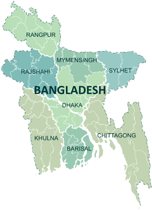 | |
|---|---|---|
| Chittagong Division | ||
| Dhaka Division | ||
| Khulna Division | ||
| Mymensingh Division | ||
| Rajshahi Division | ||
| Rangpur Division | ||
| Sylhet Division | ||