Sherpur District
| Sherpur শেরপুর | |
|---|---|
| District | |
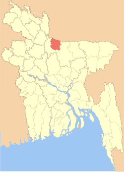 Location of Sherpur in Bangladesh | |
| Coordinates: BD 25°00′N 90°00′E / 25.00°N 90.00°ECoordinates: BD 25°00′N 90°00′E / 25.00°N 90.00°E | |
| Country |
|
| Division | Mymensingh Division |
| Area | |
| • Total | 1,359.87 km2 (525.05 sq mi) |
| Population (2011 census) | |
| • Total | 1,358,325 |
| • Density | 1,000/km2 (2,600/sq mi) |
| Time zone | BST (UTC+6) |
| Postal code | 2100 |
Sherpur (Bengali: শেরপুর জেলা, Sherpur Jela also Sherpur Zila) is a district in central Bangladesh. It is a part of Mymensingh Division. Sherpur city is located about 198 km (123.03 mi) north of Dhaka which is the capital of the country.
History
Sherpur region was a part of the kingdom of the Kamarupa in the ancient time. During the reign of the Mughal Emperor Akbar this area was called "Dashkahania Baju". During the first part of the seventeenth century the Gazis of Bhawal occupied Dashkahania area from the descendants of Isa Khan. Doshkahania Pargana was named Sherpur after Sher Ali Gazi, the last jaghirdar of the Gazi dynasty. Fakir-Sannyasi Revolts were held against the East India Company and the local zamindars from the time of warren hastings to lord cornowalis; Tipu Shah, leader of the Fakir Movement, declared sovereignty in the area and established his capital at Gajripa. Peasant conferences were held in 1906, 1914 and 1917 at Kamarer Char of Sherpur under the leadership of Khos Muhammad Chowdhury. The communists revolted against the systems of Nankar, Tonk, Bhawali, Mahajani, Ijaradari during 1838-48 in Sherpur. In 1897 a devastating earth quack changed the course of the Brahmaputra towards the west and forced to merge it with the Jamuna; it also caused serious damages to many old buildings.
Points of interest
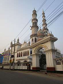
Points of interest include: Madhutila Ecopark in Nalitabari,[1] Laskar Mosque at Ghagra (1808),[2] Baraduari Mosque at Garhjaripar, Garhjaripar Fort (1486–91),[3] the Tomb of Darvish Jarip Shah, the Tomb of Hazrat Shah Kamal (1644), the Tomb of Sher Ali Gazi, the Mughal Mosque at Kasba, Maisaheba Mosque, and the residences of Nayani, Arai Ani and Pouney Tin Ani Zamindars.[4]
Administration
There are 5 upazilas (sub-district) under this district,[1] namely:
- Jhenaigati Upazila:Jhenaigati is famous for some tourist spots named Gajni, Madhutila etc.
- Nakla Upazila
- Nalitabari Upazila
- Sherpur Sadar Upazila
- Sreebardi Upazila
Media
Weekly Sherpur, Weekly Dashkahania, Weekly Chalti Khabar, Sahityaloka, Barshati, Ra, etc.; extinct: Biddaunnati Sadhini (1865), Weelky Biggapani (1865), Weekly Charybarta (1881), Bangasuridh (1881), Samskriti Sanjibini, fortnightly Kishore (1957–58), Monthly Daxina (1967), Probaha, Angan, Muktangan, Ganabarta, Aunnesa, Uccharan, Sancharan.
See also
References
| Wikimedia Commons has media related to Sherpur District. |
- 1 2 AKM Reazul Hasan (2012). "Sherpur District". In Sirajul Islam and Ahmed A. Jamal. Banglapedia: National Encyclopedia of Bangladesh (Second ed.). Asiatic Society of Bangladesh.
- ↑ "Laskar Mosque in Sherpur : A unique Mughal architectural site". The New Nation. Dhaka. June 25, 2014.
- ↑ গড়জরিপার বারোদুয়ারী মসজিদ [Garajaripara 'Baraduari' mosque]. The Daily Sangram (in Bangla). Dhaka.
- ↑ "District Statistics 2011: Sherpur" (PDF). Bangladesh Bureau of Statistics. Retrieved July 25, 2014.
| Barisal Division | 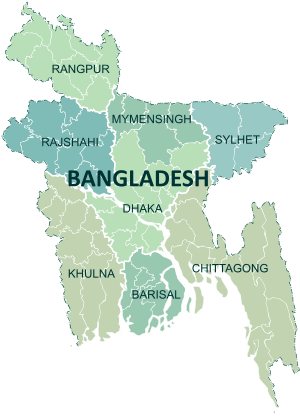 | |
|---|---|---|
| Chittagong Division | ||
| Dhaka Division | ||
| Khulna Division | ||
| Mymensingh Division | ||
| Rajshahi Division | ||
| Rangpur Division | ||
| Sylhet Division | ||