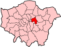
Brick Lane
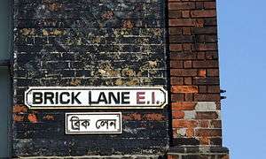
Brick Lane (Bengali: ব্রিক লেন) is a street in east London, England, in the London Borough of Tower Hamlets. It runs from Swanfield Street in the northern part of Bethnal Green, crosses Bethnal Green Road, passes through Spitalfields and is linked to Whitechapel High Street to the south by the short stretch of Osborn Street. Today, it is the heart of the city's Bangladeshi-Sylheti community and is known to some as Banglatown.[1] It is famous for its many curry houses.
Early history

15th to 18th centuries
Winding through fields, the street was formerly called Whitechapel Lane. It derives its current name from brick and tile manufacture started in the 15th century, which used the local brick earth deposits.[2] and featured in the 16th century Woodcut map of London as a partially-developed crossroad leading north from the city's most easterly edge. By the 17th century, the street was being developed northwards from the Barres (now Whitechapel High Street) as a result of expanding population.[3]
Brewing came to Brick Lane before 1680, with water drawn from deep wells. One brewer was Joseph Truman, first recorded in 1683. His family, particularly Benjamin Truman, went on to establish the sizeable Black Eagle Brewery on Brick Lane.[4] The Brick Lane Market first developed in the 17th century for fruit and vegetables sold outside the City.
Successive waves of immigrants settled in the area: in the 17th century, French Huguenots expanded into the area for housing; the master weavers were based in Spitalfields.[5] Starting with the Huguenots, the area became a centre for weaving, tailoring and the developing clothing industry. It continued to attract immigrants, who provided semi- and unskilled labour.
19th century markets and their modern use
In the 19th century, Irish people[6] and Ashkenazi Jews immigrated to the area.[7] Jewish immigration continued into the early 20th century.
The Sunday market, like the ones on Petticoat Lane and nearby Columbia Road, dates from a dispensation given by the government to the Jewish community in the 19th century. At the time, there were no Sunday markets open because of the Christian observance of Sabbath. Located at the junction of Cheshire and Sclater streets, the market sells bric-a-brac as well as fruit, vegetables and many other items. In 2015 it was identified by police as the focal point of a trade in stolen bicycles and bicycle parts, many taken from City of London employees who had used "cycle to work" schemes. Alongside seven arrests, the police also warned purchasers that buying bicycles or parts in deals "too good to be true" could make them guilty of handling stolen goods.[8] Near the junction with Hanbury Street are two indoor markets; Upmarket and Backyard Market. In 2010, the Brick Lane Farmers' Market opened, intended to be held every Sunday in nearby Bacon Street;[9] it has now closed.[10]
In the later 20th century, Bangladeshis comprised the major group of immigrants and gradually predominated in the area.[11] Many Bangladeshi immigrants to Brick Lane were from the Greater Sylhet region. These settlers helped shape Bangladeshi migration to Britain; many families from Jagannathpur and Bishwanath tend to live in the Brick Lane area.[12]
Religious groups
In 1742, La Neuve Eglise, a Huguenot chapel, was built on the corner of Brick Lane and Fournier Street. By 1809, it was used by missionaries as The Jews’ Chapel, where they promoted Christianity to the expanding Jewish population. It was adapted as a Methodist Chapel in 1819 for Protestant residents. (John Wesley had preached his first "covenant sermon" at the nearby Black Eagle Street Chapel).
Reflecting the changing demographics of the area, in 1898, the building was consecrated as the Machzikei HaDath, or Spitalfields Great Synagogue. After decades of change in the area, with Jews moving out and Bangladeshis moving in, in 1976 it was adapted again as the London Jamme Masjid (Great London Mosque) to serve the expanding Bangladeshi community.[13] The building is Grade II* listed.[14]
Bengali settlement


In the 20th century the Brick Lane area was important in the second wave of development of Anglo-Indian cuisine, as families from countries such as Bangladesh (mainly the Greater Sylhet region) migrated to London to look for work. Some curry houses of Brick Lane do not sell alcohol as most are owned by Muslims.
Bengalis in the United Kingdom settled in big cities with industrial employment. In London, many Bengali people settled in the East End. For centuries the East End has been the first port of call for many immigrants working in the docks and shipping from Chittagong port in Bengal (British Empire in India was founded and based in Bengal). Their regular stopover paved the way for food/curry outlets to be opened up catering for an all male workforce as family migration and settlement took place some decades later. Humble beginnings such as this gave birth to Brick Lane as the famous curry capital of the UK. Bengalis of Sylheti origin constitute only 10% of all South Asians in Britain; however around 90% of all South Asian restaurants in the UK are Sylheti- or Bengali-owned.
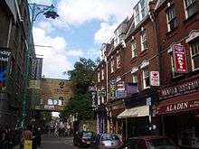
Regeneration
.jpg)
More recently the area has also broadened to being a vibrant art and fashion student area, with considerable exhibition space. Each year most of the fine art and fashion courses exhibit their work near Brick Lane.
Since the late 1990s, Brick Lane has been the site of several of the city's best known night clubs, notably 93 Feet East and The Vibe Bar, both built on the site of The Old Truman Brewery, once the industrial centre of the area, and now an office and entertainment complex.
Brick Lane has a regular display of graffiti, which features artists such as Banksy, Stik, ROA, D*Face, Ben Eine and Omar Hassan.[15] The lane has been used in many music videos such as "Glory Days" by Just Jack, "All These Things That I've Done" by The Killers and "Überlin" by R.E.M..
Land ownership and naming
Large swathes of Brick Lane and its surrounding areas were once owned by the Osborne (later Osborn after 1720) family, Baronets, of Chicksands in the County of Bedford. The family's holdings survived until at least the 1970s. The family's history continues to be reflected by the naming of streets in the area around Brick Lane, including:
- Chicksand Street reflects the village of Chicksands in Bedfordshire, location of the family seat Chicksands Priory;
- The west end of what is now Chicksand Street was once Osborn Place (see 1787 map);
- Modern Osborn Street was a renaming of the southern-most stretch of Brick Lane (see Rocque map of 1746 for this naming, altered by the time of the 1787 map);
- Heneage Street reflects the marriage of George Osborn, 4th Baronet, to Lady Heneage Finch (his 2nd wife) in April 1772;[16]
- The modern Hopetown Street was originally Finch Street, reflecting the same marriage (see 1853 map, right);
- The modern Old Montague Street was originally just Montague Street, preserving the maternal family name of George Osborn, 4th Baronet, whose mother, Mary Montague, was the daughter of George Montague, 2nd Earl of Halifax.[16] The continuation of Chicksand Street to the East (now demolished) was once Halifax Street, referencing the same marriage.
- Modern Hanbury Street is made up of 4 streets shown on the 1853 map: Browns Lane, Montague Street (triggering the addition of 'Old' to the earlier street of the same name), Well Street and Church Street.

 Map, publisher unknown, dated 1787, showing Spitalfields (Spittlefields) and its environs
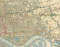 An extract from Cross's New Plan Of London, showing Stepney and surrounding areas. Published 1853 by J.Cross of London.
Buildings of interest
Nearby buildings of interest include Christ Church, Spitalfields, The Jamme Masjid or Great London Mosque on the corner of Fournier Street (the building represents a history of successive communities of immigrants in East End) and The Rag Factory on Heneage Street (once home to Turner Prize nominees Tracey Emin and Gary Hume, now a thriving arts space).
Transport
The nearest London Underground stations are Aldgate East and Liverpool Street. In 2006 a campaign was launched to change the name of the Aldgate East station to "Brick Lane",[17] but received no official support.
The nearest London Overground station is Shoreditch High Street station. This line runs on part of the former East London Line which has now been converted to London Overground. At the junction with Pedley Street exists the former Shoreditch tube station which closed in 2006 due to underuse. Remnants of the station can be seen from trains entering and leaving Liverpool Street station.
In popular culture
The street is the location for Monica Ali's book Brick Lane, published in 2003, and the film of 2007 starring Tannishtha Chatterjee. The novel provoked a controversy with some of the local South Asian community because of a perceived negative portrayal of them. Parts of the Bengali community were particularly opposed to plans by Ruby Films to film parts of the novel in the Brick Lane area and formed the "Campaign Against Monica Ali's Film Brick Lane." Consequently, the producers of the film used different locations for certain scenes, such as that depicting Brick Lane Market. Despite this, the director of the film, Sarah Gavron, attests on the DVD commentary of the film that genuine footage of Brick Lane does appear in the finished movie. Activists told The Guardian they intended to burn copies of Ali's book during a rally to be held on 30 July 2006, but the demonstration passed without incident.[18]
Other notable books on the area are Salaam Brick Lane by Tarquin Hall,[19] On Brick Lane (2007) by Rachel Lichtenstein and An Acre of Barren Ground by Jeremy Gavron.[20] A large collection of photographs of the characters and sales people who worked the markets in Brick Lane were taken by Fran May between 1976 and 1978, encouraged by Bill Brandt while Fran was a student of photography at the Royal College of Art.[21]
The street has been used for several filming locations for the BBC television show Luther (2013) in its third season.
See also
- Beigel Bake
- British Bangladeshi
- Brick Lane Market
- Spitalfields
- Old Truman Brewery - The Black Eagle Brewery, on Brick Lane
References
- ↑ Spitalfields and Banglatown (London Borough of Tower Hamlets) accessed 1 November 2007
- ↑ "Stepney: Economic History", A History of the County of Middlesex: Volume 11: Stepney, Bethnal Green (1998), pp. 52-63 Retrieved 15 October 2007
- ↑ "Bethnal Green: The West: Shoreditch Side, Spitalfields, and the Nichol", A History of the County of Middlesex: Volume 11: Stepney, Bethnal Green (1998), pp. 103-109 Retrieved 15 October 2007.
- ↑ The Black Eagle Brewery, Brick Lane, Survey of London: volume 27: Spitalfields and Mile End New Town (1957), pp. 116-122 Retrieved 15 October 2007.
- ↑ "Bethnal Green: Settlement and Building to 1836", A History of the County of Middlesex: Volume 11: Stepney, Bethnal Green (1998), pp. 91-5 Date Retrieved 17 April 2007
- ↑ John A. Jackson, Irish in Britain , 137-9, 150 (Routledge & Kegan Paul, 1964)
- ↑ The Jews, A History of the County of Middlesex: Volume 1: Physique, Archaeology, Domesday, Ecclesiastical Organization, The Jews, Religious Houses, Education of Working Classes to 1870, Private Education from Sixteenth Century (1969), pp. 149-51 Date Retrieved 17 April 2007
- ↑ Watts, Matt (18 May 2015). "Seven held at market as police target 'heart' of stolen bike trade". London Evening Standard. p. 18.
- ↑ 'Brick Lane Farmers Market Opens', LFM
- ↑ "London Farmers' Markets | Brick Lane Farmers' Market".
- ↑ The Spatial Form of Bangladeshi Community in London's East End Iza Aftab (UCL) (particularly background of Bangladeshi immigration to the East End). Date Retrieved 17 April 2007
- ↑ Michael Smith, John Eade (2008). Transnational Ties: Cities, Migrations, and Identities. Transaction Publishers. pp. 148-149.
- ↑ Lucy Dixon, "A brief history of the Mosque", My Tower Hamlets website, Retrieved 15 October 2007 Archived 28 August 2007 at the Wayback Machine.
- ↑ Historic England. "Details from image database (205992)". Images of England. Retrieved 14 April 2009
- ↑ "Bringing Colour to the Block". Hookedblog — UK Street Art. Retrieved 2016-03-21.
- 1 2 Cokayne (compiler), G. E. (1904). The Complete Baronetage, Volume 3. Exeter, UK: William Pollard & Co Ltd. pp. 243–44.
- ↑ "Bid to name Tube stop Brick Lane". BBC. 15 December 2006. Retrieved 10 January 2007.
- ↑ Cacciottolo, Mario. "Brick Lane protesters hurt over 'lies'", BBC News, 31 July 2006.
- ↑ Icons meets Tarquin Hall
- ↑ http://www.theguardian.com/books/2005/apr/02/featuresreviews.guardianreview22
- ↑ http://www.franmay.com
External links
| Wikimedia Commons has media related to Brick Lane. |
- Brick Lane entry at the Survey of London (1957)
- Brick Lane through the last two hundred years, including many genealogical pubs.
- Virtual e-Tour Brick Lane Shockwave Player required
- Our Brick Lane - Eastside Community Heritage
Coordinates: 51°31′19″N 0°4′18″W / 51.52194°N 0.07167°W