Suntex, Oregon
| Suntex, Oregon | |
|---|---|
| Unincorporated community | |
 Suntex, Oregon  Suntex, Oregon Location within the state of Oregon | |
| Coordinates: 43°35′27″N 119°37′49″W / 43.59083°N 119.63028°WCoordinates: 43°35′27″N 119°37′49″W / 43.59083°N 119.63028°W | |
| Country | United States |
| State | Oregon |
| County | Harney |
| Elevation | 4,308 ft (1,313 m) |
| Time zone | PST (UTC-8) |
| • Summer (DST) | PDT (UTC-7) |
| Area code(s) | 541 |
| Coordinates and elevation from United States Geological Survey[1] | |
Suntex was the name of a post office in an unincorporated community in Harney County, in the U.S. state of Oregon. It was established in the valley of Silver Creek west of Burns and north of U.S. Route 20.[2]
The Suntex post office was set up in 1916 and closed in 1949, after which Suntex mail was handled through the post office in Riley. W. F. Sturges, the first postmaster at Suntex, said that postal authorities had assigned the name "Suntex", which had no local significance, for reasons he was unaware of.[3]
References
- ↑ "Suntex". Geographic Names Information System. United States Geological Survey. May 22, 1986. Retrieved January 4, 2016.
- ↑ "United States Topographic Map". United States Geological Survey. Retrieved January 4, 2016 – via Acme Mapper.
- ↑ McArthur, Lewis A.; McArthur, Lewis L. (2003) [1928]. Oregon Geographic Names (7th ed.). Portland, Oregon: Oregon Historical Society Press. p. 925. ISBN 0-87595-277-1.
Municipalities and communities of Harney County, Oregon, United States | ||
|---|---|---|
| Cities | 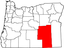 | |
| CDP | ||
| Other unincorporated communities | ||
| Indian reservation | ||
| Ghost town | ||
This article is issued from Wikipedia - version of the 7/30/2016. The text is available under the Creative Commons Attribution/Share Alike but additional terms may apply for the media files.