Riley, Oregon
| Riley, Oregon | |
|---|---|
| Unincorporated town | |
|
Post office in Riley | |
 Riley, Oregon  Riley, Oregon Location within the state of Oregon | |
| Coordinates: 43°32′30″N 119°30′14″W / 43.54167°N 119.50389°WCoordinates: 43°32′30″N 119°30′14″W / 43.54167°N 119.50389°W | |
| Country | United States |
| State | Oregon |
| County | Harney |
| Elevation | 4,226 ft (1,288 m) |
| Time zone | PST (UTC-8) |
| • Summer (DST) | PDT (UTC-7) |
| ZIP codes | 97758 |
| Area code(s) | 541 |
| Coordinates and elevation from United States Geological Survey[1] | |

Riley, Oregon is an unincorporated community in Harney County, Oregon, United States, located at the crossroads of U.S. Highway 395 and U.S. Highway 20, milepost 104, about 28 miles (45 km) west of Burns, the seat of Harney County. The elevation of Riley is 4,226 feet (1,288 m). The town presently consists entirely of two service establishments with attached apartments: a post office, and a general store with gas pump and garage service. It exists to serve highway travelers, and the rural farming and ranching community that surrounds it.
Farmers grow alfalfa, hay, and root crops.[2]
The town springs from the establishment of a post office in about 1885, which was named for stockman Amos Riley of the ranching partnership Riley and Hardin.[3][4] There was a Hardin post office located 75 miles (121 km) northwest of Riley, so the people who lived along Silver Creek suggested the new post office be called Riley.[3] Riley's post office closed in 1919, but was reopened in 1949 after an office called Suntex was closed.[3]
The Oregon Department of Transportation has a camera for road and weather conditions located at the intersection of U.S. 20 and U.S. 395 in Riley, facing west-northwest.[5]
Climate
According to the Köppen Climate Classification system, Riley has a semi-arid climate, abbreviated "BSk" on climate maps.[6]
Points of interest
Transportation
In the 21st century, Riley is a stop on the Eastern POINT intercity bus line between Bend and Ontario. It makes one stop per day in each direction.[7]
References
- ↑ "Riley". Geographic Names Information System. United States Geological Survey. November 28, 1980. Retrieved August 24, 2009.
- ↑ "Riley Rural Community". Harney County Chamber of Commerce. Retrieved July 24, 2011.
- 1 2 3 McArthur, Lewis A.; Lewis L. McArthur (2003) [1928]. Oregon Geographic Names (7th ed.). Portland, Oregon: Oregon Historical Society Press. p. 812. ISBN 0-87595-277-1.
- ↑ Harney County Comprehensive Plan
- ↑ TripCheck - Road Cams, Road & Weather Conditions in Oregon
- ↑ "Riley, Oregon". Weatherbase. CantyMedia. Retrieved January 5, 2016.
- ↑ "Eastern Point Schedule". Oregon Department of Transportation. Retrieved January 5, 2016.
External links
Municipalities and communities of Harney County, Oregon, United States | ||
|---|---|---|
| Cities | 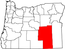 | |
| CDP | ||
| Other unincorporated communities | ||
| Indian reservation | ||
| Ghost town | ||