Suda, Nepal
| Suda सुडा | |
|---|---|
| Village development committee | |
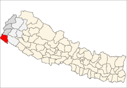
 Suda  Suda Map of the village development committees in Kanchanpur District | |
| Coordinates: 28°59′N 80°14′E / 28.99°N 80.23°ECoordinates: 28°59′N 80°14′E / 28.99°N 80.23°E | |
| Country |
|
| Zone | Mahakali Zone |
| District | Kanchanpur District |
| Population (1991) | |
| • Total | 12,948 |
| Time zone | Nepal Time (UTC+5:45) |
Suda is a village development committee in Kanchanpur District in the Mahakali Zone of south-western Nepal. At the time of the 1991 Nepal census it had a population of 12,948 people living in 1947 individual households.[1] <villages>
References
- ↑ "Nepal Census 2001". Nepal's Village Development Committees. Digital Himalaya. Retrieved 24 November 2008.
Headquarter: Mahendranagar | ||
 | ||
2.kamal Nath Yogi (local inhabitant)
This article is issued from Wikipedia - version of the 9/12/2016. The text is available under the Creative Commons Attribution/Share Alike but additional terms may apply for the media files.