Staré Hutě
| Staré Hutě | ||
|---|---|---|
| Municipality | ||
 | ||
| ||
 Staré Hutě | ||
| Coordinates: 49°8′28″N 17°16′40″E / 49.14111°N 17.27778°ECoordinates: 49°8′28″N 17°16′40″E / 49.14111°N 17.27778°E | ||
| Country |
| |
| Region | Zlín | |
| District | Uherské Hradiště | |
| Area | ||
| • Total | 7.36 km2 (2.84 sq mi) | |
| Elevation | 393 m (1,289 ft) | |
| Population (2006) | ||
| • Total | 137 | |
| • Density | 19/km2 (48/sq mi) | |
| Postal code | 686 01 to 686 02 | |
| Website | http://www.starehute.cz | |

Staré Hutě is a village and municipality (obec) in Uherské Hradiště District in the Zlín Region of the Czech Republic.
The municipality covers an area of 7.36 square kilometres (2.84 sq mi), and has a population of 137 (as at 3 July 2006).
Staré Hutě lies approximately 16 kilometres (10 mi) north-west of Uherské Hradiště, 31 km (19 mi) west of Zlín, and 232 km (144 mi) south-east of Prague.
Gallery
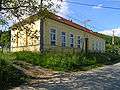 Old school
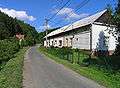 Main street
References
| Wikimedia Commons has media related to Staré Hutě. |
This article is issued from Wikipedia - version of the 4/8/2016. The text is available under the Creative Commons Attribution/Share Alike but additional terms may apply for the media files.