St Philip Parish, Cumberland
| St Philip New South Wales | |||||||||||||
|---|---|---|---|---|---|---|---|---|---|---|---|---|---|
 Location in Sydney city highlighted in blue | |||||||||||||
| Established | 1835 | ||||||||||||
| LGA(s) | City of Sydney | ||||||||||||
| County | Cumberland | ||||||||||||
| Hundred (former) | Sydney | ||||||||||||
| |||||||||||||
St Philip Parish is one of the 57 parishes of Cumberland County, New South Wales, a cadastral unit for use on land titles. It is located on the western part of the original colony at Sydney Cove, which was to the west of the Tank Stream. It is one of the four small parishes in the Sydney city area and is named after the church of St Philip's. It includes the southern end of the Sydney Harbour Bridge, The Rocks, Dawes Point and Millers Point. It is bounded by Sydney Harbour in the north, King Street in the south, George Street in the south-east, and what was once the Tank Stream in the east (now near a small part of Hunter Street, Milton street and part of Pitt Street in the east, near but not including Circular Quay). The northern end of Darling Harbour is the boundary in the west.[1] It includes Wynyard railway station.
Locations
Images of locations in the Parish of St Philip:
 The Dawes Point (southern) end of the Sydney Harbour Bridge
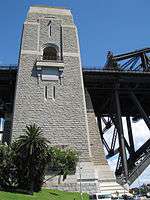
%2C_Sydney_-_Wiki0045.jpg) The tower of St Philip's Church, Sydney, (1848–58)
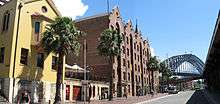
The tower of St Philip's Church, Sydney, (1848–58) Museum of Contemporary Art on the eastern end of the parish.
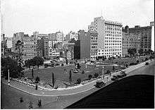 Wynyard Park and the block behind it is in the Parish of Philip, with the buildings in the distance in St James
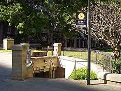
Coordinates: 33°51′51″S 151°12′22″E / 33.86417°S 151.20611°E
References
- ↑ Information obtained from maps available at the NSW Dept. of Lands Parish map preservation project
- "St Philip". Geographical Names Register (GNR) of NSW. Geographical Names Board of New South Wales.
- Map of the Parish of St. Philip, County of Cumberland, 1930, National Library of Australia