South Solon, Ohio
| South Solon 2015 Ohio | |
|---|---|
| Village | |
|
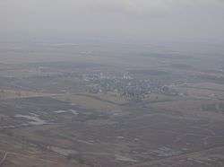
South Solon from the air | |
| Nickname(s): s.Solon or south.s | |
 Location of South Solon, Ohio | |
 Location of South Solon in Madison County | |
| Coordinates: 39°44′16″N 83°36′41″W / 39.73778°N 83.61139°WCoordinates: 39°44′16″N 83°36′41″W / 39.73778°N 83.61139°W | |
| Country | United States |
| State | Ohio |
| County | Madison |
| Area[1] | |
| • Total | 0.25 sq mi (0.65 km2) |
| • Land | 0.25 sq mi (0.65 km2) |
| • Water | 0 sq mi (0 km2) |
| Elevation[2] | 1,115 ft (340 m) |
| Population (2010)[3] | |
| • Total | 355 |
| • Estimate (2012[4]) | 355 |
| • Density | 1,420.0/sq mi (548.3/km2) |
| Time zone | Eastern (EST) (UTC-5) |
| • Summer (DST) | EDT (UTC-4) |
| ZIP code | 43153 |
| Area code(s) | 740 |
| FIPS code | 39-73768[5] |
| GNIS feature ID | 1065356[2] |
South Solon is a village in Madison County, Ohio, United States. The population was 355 at the 2010 census.
Despite their similar names, South Solon is not adjacent to the city of Solon, Ohio, a suburb of Cleveland in Cuyahoga County. The two towns are approximately 170 miles apart.
History

As of 1875, the community contained a post office, one grocery store, and one blacksmith shop.[6] The village's community building was constructed in 1938 by the Public Works Administration at an estimated cost of $25,454.[7]
Geography
South Solon is located at 39°44′16″N 83°36′41″W / 39.73778°N 83.61139°W (39.737861, -83.611277).[8]
According to the United States Census Bureau, the village has a total area of 0.25 square miles (0.65 km2), all land.[1]
Demographics
| Historical population | |||
|---|---|---|---|
| Census | Pop. | %± | |
| 1880 | 262 | — | |
| 1890 | 345 | 31.7% | |
| 1900 | 319 | −7.5% | |
| 1910 | 420 | 31.7% | |
| 1920 | 442 | 5.2% | |
| 1930 | 409 | −7.5% | |
| 1940 | 376 | −8.1% | |
| 1950 | 414 | 10.1% | |
| 1960 | 414 | 0.0% | |
| 1970 | 415 | 0.2% | |
| 1980 | 416 | 0.2% | |
| 1990 | 379 | −8.9% | |
| 2000 | 405 | 6.9% | |
| 2010 | 355 | −12.3% | |
| Est. 2015 | 361 | [9] | 1.7% |
2010 census
As of the census[3] of 2010, there were 355 people, 123 households, and 94 families residing in the village. The population density was 1,420.0 inhabitants per square mile (548.3/km2). There were 145 housing units at an average density of 580.0 per square mile (223.9/km2). The racial makeup of the village was 96.9% White, 0.3% African American, 0.3% Native American, and 2.5% from two or more races. Hispanic or Latino of any race were 2.5% of the population.
There were 123 households of which 38.2% had children under the age of 18 living with them, 56.9% were married couples living together, 11.4% had a female householder with no husband present, 8.1% had a male householder with no wife present, and 23.6% were non-families. 17.1% of all households were made up of individuals and 6.5% had someone living alone who was 65 years of age or older. The average household size was 2.89 and the average family size was 3.18.
The median age in the village was 37.5 years. 24.5% of residents were under the age of 18; 11.1% were between the ages of 18 and 24; 27.4% were from 25 to 44; 26% were from 45 to 64; and 11.3% were 65 years of age or older. The gender makeup of the village was 50.7% male and 49.3% female.
2000 census
As of the census[5] of 2000, there were 405 people, 141 households, and 108 families residing in the village. The population density was 2,033.3 people per square mile (781.9/km²). There were 152 housing units at an average density of 763.1 per square mile (293.4/km²). The racial makeup of the village was 99.01% White, 0.25% Native American, 0.49% Asian, and 0.25% from two or more races. Hispanic or Latino of any race were 0.99% of the population.
There were 141 households out of which 40.4% had children under the age of 18 living with them, 56.0% were married couples living together, 11.3% had a female householder with no husband present, and 22.7% were non-families. 16.3% of all households were made up of individuals and 9.9% had someone living alone who was 65 years of age or older. The average household size was 2.87 and the average family size was 3.25.
In the village the population was spread out with 31.4% under the age of 18, 10.6% from 18 to 24, 30.6% from 25 to 44, 17.3% from 45 to 64, and 10.1% who were 65 years of age or older. The median age was 31 years. For every 100 females there were 103.5 males. For every 100 females age 18 and over, there were 101.4 males.
The median income for a household in the village was $34,583, and the median income for a family was $38,750. Males had a median income of $28,456 versus $18,750 for females. The per capita income for the village was $15,152. About 8.4% of families and 10.0% of the population were below the poverty line, including 16.5% of those under age 18 and 3.6% of those age 65 or over.
References
- 1 2 "US Gazetteer files 2010". United States Census Bureau. Retrieved 2013-01-06.
- 1 2 "US Board on Geographic Names". United States Geological Survey. 2007-10-25. Retrieved 2008-01-31.
- 1 2 "American FactFinder". United States Census Bureau. Retrieved 2013-01-06.
- ↑ "Population Estimates". United States Census Bureau. Retrieved 2013-06-17.
- 1 2 "American FactFinder". United States Census Bureau. Retrieved 2008-01-31.
- ↑ J. A. Caldwell, Caldwell's Atlas of Madison County, Ohio, Condit, Ohio, 1875, Pg. 10.
- ↑ "Construction Projects Approved by Public Works Administration". The Lather 39.1 (1983): 20.
- ↑ "US Gazetteer files: 2010, 2000, and 1990". United States Census Bureau. 2011-02-12. Retrieved 2011-04-23.
- ↑ "Annual Estimates of the Resident Population for Incorporated Places: April 1, 2010 to July 1, 2015". Retrieved July 2, 2016.
- ↑ "Census of Population and Housing". Census.gov. Retrieved June 4, 2015.
Municipalities and communities of Madison County, Ohio, United States | ||
|---|---|---|
| City | 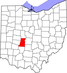 | |
| Villages | ||
| Townships | ||
| CDPs | ||
| Unincorporated communities | ||
| Footnotes | ‡This populated place also has portions in an adjacent county or counties | |