South Dagon Township
| South Dagon Township ဒဂုံမြို့သစ်တောင်ပိုင်း မြို့နယ် | |
|---|---|
| Township of Yangon | |
| South Dagon Township | |
 South Dagon Township | |
| Coordinates: 16°51′0″N 96°14′0″E / 16.85000°N 96.23333°ECoordinates: 16°51′0″N 96°14′0″E / 16.85000°N 96.23333°E | |
| Country | Myanmar |
| Division | Yangon |
| City | Yangon |
| Township | South Dagon |
| Settled | 1989[1] |
| Area | |
| • Total | 79.11 km2 (30.545 sq mi) |
| Population (2000)[2] | |
| • Total | 185,000 |
| • Density | 2,300/km2 (6,100/sq mi) |
| Time zone | MST (UTC6:30) |
| Postal codes | 11431, 11432, 11433, 11434 |
| Area code(s) | 1 (mobile: 80, 99) |
| YCDC[2] | |
South Dagon Township (also South Dagon Myothit; Burmese: ဒဂုံမြို့သစ်တောင်ပိုင်း မြို့နယ် [dəɡòʊɴ mjo̰ðɪʔ tàʊɴbáɪɴ mjo̰nɛ̀]) is located in the southeastern part of Yangon, Myanmar. The township comprises 26 wards and three village tracts, and shares borders with North Dagon Township and East Dagon Township in the north, Thingangyun Township in the west across the Pazundaung Creek, the Bago River in the east, and Dagon Seikkan Township in the south.[2] South Dagon is one of the new satellite towns founded in 1989 by the military government.
The township has 31 primary schools, seven middle schools and three high schools.[2] It is home to the University of Culture, Yangon.
References
- ↑ Kyaw Kyaw (2006). Frauke Krass; Hartmut Gaese; Mi Mi Kyi, eds. Megacity yangon: transformation processes and modern developments. Berlin: Lit Verlag. pp. 333–334. ISBN 3-8258-0042-3.
- 1 2 3 4 "South Dagon Township". Yangon City Development Committee. Archived from the original on 2 October 2011. Retrieved 2009-03-21.
Capital: Yangon | ||
| East Yangon District |  | |
| North Yangon District | ||
| South Yangon District | ||
| West Yangon District (Downtown) | ||
Capital: Yangon | ||
| East Yangon District |  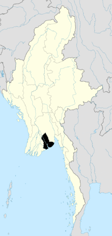 | |
| North Yangon District | ||
| South Yangon District | ||
| West Yangon District (Downtown) | ||
| Main cities and towns | ||
| States | ||
|---|---|---|
| Regions | ||
| Self-Administered Zones | ||
| Self-Administered Divisions | ||
| Union Territories | ||
This article is issued from Wikipedia - version of the 6/10/2016. The text is available under the Creative Commons Attribution/Share Alike but additional terms may apply for the media files.