Seikkyi Kanaungto Township
| Seikkyi Kanaungto Township ဆိပ်ကြီးခနောင်တို မြို့နယ် | |
|---|---|
| Township of Yangon | |
| Seikkyi Kanaungto Township | |
 Seikkyi Kanaungto Township | |
| Coordinates: 16°45′30″N 96°7′0″E / 16.75833°N 96.11667°ECoordinates: 16°45′30″N 96°7′0″E / 16.75833°N 96.11667°E | |
| Country | Myanmar |
| Division | Yangon |
| City | Yangon |
| Township | Dawbon |
| Area | |
| • Total | 5.9 km2 (2.26 sq mi) |
| Population (2000)[1] | |
| • Total | 21,000 |
| • Density | 3,600/km2 (9,300/sq mi) |
| Time zone | MST (UTC6:30) |
| Postal codes | 11271 |
| Area code(s) | 1 (mobile: 80, 99) |
| YCDC[1] | |
Seikkyi Kanaungto Township (Burmese: ဆိပ်ကြီးခနောင်တို မြို့နယ် [sʰeɪʔtɕí kʰənàʊɴtò mjo̰nɛ̀]) is located on the southwestern bank of Yangon river across from downtown Yangon, Myanmar. The township comprises eight wards, and is bounded by the Yangon river in the north, the Twante Canal in the east, and Twante Township in the south and west. The township is still largely rural and undeveloped mainly because it still lacks a bridge across the Yangon river to downtown.
Seikkyi Kanaungto has 16 primary schools, and one high school.[1]
References
- 1 2 3 "Dawbon Township". Yangon City Development Committee. Archived from the original on 2 October 2011. Retrieved 2009-03-21.
Capital: Yangon | ||
| East Yangon District |  | |
| North Yangon District | ||
| South Yangon District | ||
| West Yangon District (Downtown) | ||
Capital: Yangon | ||
| East Yangon District |  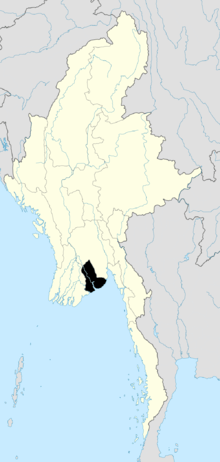 | |
| North Yangon District | ||
| South Yangon District | ||
| West Yangon District (Downtown) | ||
| Main cities and towns | ||
| States | ||
|---|---|---|
| Regions | ||
| Self-Administered Zones | ||
| Self-Administered Divisions | ||
| Union Territories | ||
This article is issued from Wikipedia - version of the 4/3/2016. The text is available under the Creative Commons Attribution/Share Alike but additional terms may apply for the media files.