Shwepyitha Township
| Shwepyitha Township ရွှေပြည်သာ မြို့နယ် | |
|---|---|
| Township of Yangon | |
| Shwepyitha Township | |
 Shwepyitha Township | |
| Coordinates: 16°58′10″N 96°4′41″E / 16.96944°N 96.07806°ECoordinates: 16°58′10″N 96°4′41″E / 16.96944°N 96.07806°E | |
| Country | Myanmar |
| Division | Yangon |
| City | Yangon |
| Township | Shwepyitha |
| Settled | 1986[1] |
| Area | |
| • Total | 39.4 km2 (15.21 sq mi) |
| Population (2012)[2] | |
| • Total | 203,000 |
| • Density | 5,200/km2 (13,000/sq mi) |
| Time zone | MST (UTC6:30) |
| Postal codes | 11411 |
| Area code(s) | 1 (mobile: 80, 99) |
| YCDC[2] | |
Shwepyitha Township (Burmese: ရွှေပြည်သာ မြို့နယ်, pronounced: [ʃwèpjìθà mjo̰nɛ̀]) is located in the northwestern part of Yangon, Myanmar. The township comprises 15 wards and five village tracts, and shares borders with Htantabin Township in the north, Mingaladon Township in the east, the Yangon river in the west, and Insein Township in the south.[2] Incorporated into the city of Yangon in 1986, Shwepyitha is still largely undeveloped and lacks basic municipal services.
Education
The township has 43 primary schools, three middle schools and four high schools.[2] The most famous high school is B.E.H.S no[1].[2]
References
- ↑ Kyaw Kyaw (2006). Frauke Krass; Hartmut Gaese; Mi Mi Kyi, eds. Megacity yangon: transformation processes and modern developments. Berlin: Lit Verlag. pp. 333–334. ISBN 3-8258-0042-3.
- 1 2 3 4 5 "Shwepyitha Township". Yangon City Development Committee. Archived from the original on 2 October 2011. Retrieved 2009-03-21.
Capital: Yangon | ||
| East Yangon District |  | |
| North Yangon District | ||
| South Yangon District | ||
| West Yangon District (Downtown) | ||
Plus- 2016 April 28
(Many without license mortor cycles are deadly driving at night and they can be in danger themselves and they even drive while others people are asleep.)BH
Capital: Yangon | ||
| East Yangon District |  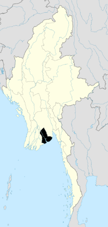 | |
| North Yangon District | ||
| South Yangon District | ||
| West Yangon District (Downtown) | ||
| Main cities and towns | ||
| States | ||
|---|---|---|
| Regions | ||
| Self-Administered Zones | ||
| Self-Administered Divisions | ||
| Union Territories | ||