Kayin State
| Kayin State ကရင်ပြည်နယ် Karen State | ||
|---|---|---|
| State | ||
| Myanma transcription(s) | ||
| • Burmese | ka.yang pranynai | |
| ||
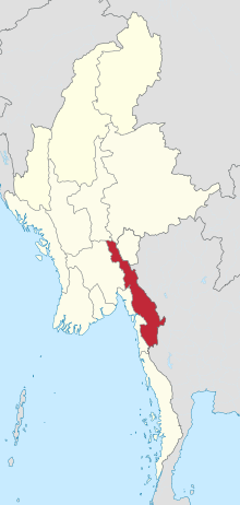 Location of Kayin State in Myanmar | ||
| Coordinates: 17°0′N 97°45′E / 17.000°N 97.750°ECoordinates: 17°0′N 97°45′E / 17.000°N 97.750°E | ||
| Country |
| |
| Region | South | |
| Capital | Hpa-An | |
| Government | ||
| • Chief Minister | Nang Khin Htwe Myint (NLD) | |
| • Legislature | Kayin State Hluttaw | |
| Area | ||
| • Total | 30,382.8 km2 (11,730.9 sq mi) | |
| Area rank | 11th | |
| Population (2014 Census)[1] | ||
| • Total | 1,574,079 | |
| • Rank | 11th | |
| • Density | 52/km2 (130/sq mi) | |
| Demographics | ||
| • Ethnicities | Karen, Padaung, Bamar, Shan, Pa-O, Mon, Rakhine, Burmese-Thai | |
| • Religions | Buddhism, Christianity, Islam, Hinduism, animism | |
| Time zone | MST (UTC+06:30) | |
| Website |
www | |

Kayin State (Burmese: ကရင်ပြည်နယ်, pronounced: [kəjɪ̀ɴ pjìnɛ̀] also Karen State), Karen: ကညီကီၢ်ဆဲ [Kanyaw Kawhseh] is a state of Myanmar. The capital city is Hpa-An, also spelled Pa-An.
The relief of Kayin State is mountainous with the Dawna Range running along the state in a NNW - SSE direction and the southern end of the Karen Hills in the northwest.[2] It is bordered by Mae Hong Son, Tak, and Kanchanaburi provinces of Thailand to the east; Mon State and Bago Region to the west and south; Mandalay Region, Shan State and Kayah State to the north.
History
| Historical population | ||
|---|---|---|
| Year | Pop. | ±% |
| 1973 | 858,429 | — |
| 1983 | 1,055,359 | +22.9% |
| 2014 | 1,574,079 | +49.2% |
| Source: 2014 Myanmar Census[1] | ||
The region that forms today's Kayin State was part of successive Burmese kingdoms since the formation of the Pagan Empire in mid-11th century. During the 13th to 16th centuries, much of the region belonged to the Hanthawaddy Kingdom while the northern part of the region belonged to Taungoo, which was a vassal state of Ava Kingdom. The region then became part of Taungoo Dynasty and Konbaung Dynasty from 16th to 19th centuries. The British seized the southern third of today's Kayin State (below the Salween River) after the First Anglo-Burmese War (1824-1826), and the rest after the Second Anglo-Burmese War of 1852.
Towards the end of the British colonial era (1945-1948), the Karen leadership insisted on a separate state covering today's Kayin State and much of Mon State and Taninthayi Region, within the British Empire. They refused to sign the Panglong Agreement of February 1947, which was the basis for the 1947 Constitution of Burma, and boycotted the pre-independence elections of April 1947.[3] Nonetheless, the constitution granted the Karen a state, though with an area less than what the Karen leadership had asked for from the British. The constitution also guaranteed states with the right to secede from the Union after a period of 10 years. (The Panglong Agreement gave only the Shan and the Kachin a state each; the Chin who actually signed the agreement did not receive a state.) The Karen National Union, which dominated the Karen leadership, was not satisfied, and wanted outright independence. In 1949, the KNU raised a rebellion that continues up to today.[4] The KNU celebrates January 31 as 'revolution day', marking the day they went underground at the battle of Insein.
Much of the state has been a battlefield since then. The civilians have taken the brunt of the war. The KNU today forms the world's longest running resistance. The English name of the state was changed to Kayin State from Karen State in 1989 by the military government.
Geography
Located between latitudes 15° 45' north and 19° 25' north and longitudes 96° 10' east and 98° 28' east. It has a hot and humid climate because of the mountain ranges that lie in its backdrop and its location, which is near the sea, in the tropics. The temperature of the hottest month in eastern mountain regions never falls below 22.2 °C (71.9 °F). Lowlands in the west and south of the state are located in the tropical monsoon climate. The lowest annual rainfall in the region is 3,000 millimetres (120 in) and the highest is 4,800 millimetres (190 in). The regions get most of the rain in summer.
Some of the rivers and creeks in Kayin State are flowing from south to north due to the location of mountains. The main rivers in the state are Thanlwin (Salween River), Thaungyin (Moei River), Gyaing and Attaran.
Administrative divisions
Kayin State consists of one city and nine towns. It has four districts, seven townships and 4092 villages.
Districts
Townships
- Hpa-an Township
- Hlaignbwe Township
- Hpapun Township
- Thandaunggyi Township
- Myawaddy Township
- Kawkareik Township
- Kyain Seikgyi Township
Cities and towns
- Hpa-an
- Hlaignbwe
- Hpapun
- Thandang
- Thandanggyi
- Myawaddy
- Kawkareik
- Kyaikdo
- Kyain Seikgyi
- Payathonsu
- Kyone Doe
Government
Legislature
2010 elections
During the 2010 elections of Burma three different Karen political parties participated. The Karen Peoples Party (KPP) gained 6 seats. The Ploung-Sgaw Democracy Party (PSDP) gained 9 seats. The Karen State Democracy and Development Party (KSDDP) gained 2 seats.[5] Final results show the pro-government USDP won 874 of the 1140 seats.
Transport
Kayin State is served by Hpapun airport and Hpa-An airport but none of those currently use for public transportation.
Education
Major universities in Kayin state include Hpa-A University, Computer University, Hpa-An and Technological University, Hpa-An.
Educational opportunities in Burma are extremely limited outside the main cities of Yangon and Mandalay. It is especially a problem in Kayin State where constant fighting between the government and insurgents for over 60 years has produced thousands of refugees and internally displaced people. According to official statistics, less than 10% of primary school students in Kayin State reach high school.[6] All the institutions of higher education are located in Hpa-An.
| AY 2002-2003 | Primary | Middle | High |
|---|---|---|---|
| Schools | 1139 | 78 | 31 |
| Teachers | 3400 | 1200 | 400 |
| Students | 148,000 | 47,000 | 12,000 |
Health care
The general state of health care in Burma is poor. The military government spends anywhere from 0.5% to 3% of the country's GDP on health care, consistently ranking among the lowest in the world.[7][8] Although health care is nominally free, in reality, patients have to pay for medicine and treatment, even in public clinics and hospitals. Public hospitals lack many of the basic facilities and equipment.
In general, the health care infrastructure outside of Yangon and Mandalay is extremely poor but is especially worse in conflict ridden areas like Kayin State. The public health care system in the state is almost non-existent. The entire Kayin State has fewer hospital beds than the Yangon General Hospital. The following is a summary of the public health care system in the state.[9]
| 2002–2003 | # Hospitals | # Beds |
|---|---|---|
| Specialist hospitals | 0 | 0 |
| General hospitals with specialist services | 1 | 200 |
| General hospitals | 7 | 275 |
| Health clinics | 17 | 272 |
| Total | 25 | 747 |
See also
- Annual Dry Season Offensive
- Karen Human Rights Group
- Democratic Karen Buddhist Army
- Karen National Union
- Karen National Liberation Army
References
- 1 2 Census Report. The 2014 Myanmar Population and Housing Census. 2. Naypyitaw: Ministry of Immigration and Population. May 2015. p. 17.
- ↑ The Physical Geography of Southeast Asia, Avijit Gupta, Oxford University Press, 2005. ISBN 978-0-19-924802-5
- ↑ Thant Myint-U (2006). The River of Lost Footsteps--Histories of Burma. Farrar, Straus and Giroux. p. 253. ISBN 978-0-374-16342-6.
- ↑ Myint-U, pp. 258-263
- ↑ Burma's Longest War: Anatomy of the Karen Conflict pages 27 -30
- ↑ "Education statistics by level and by State and Division". Myanmar Central Statistical Organization. Retrieved 2009-04-09.
- ↑ "PPI: Almost Half of All World Health Spending is in the United States". 2007-01-17.
- ↑ Yasmin Anwar (2007-06-28). 06.28.2007 "Burma junta faulted for rampant diseases" Check
|url=value (help). UC Berkeley News. - ↑ "Hospitals and Dispensaries by State and Division". Myanmar Central Statistical Organization. Retrieved 2009-04-11.
External links
- Burma's Longest War: Anatomy of the Karen Conflict 2011, Ashley South at the Transnational Institute
- "Planning Map Kayin State" 2008, Myanmar Information Management Unit (MIMU)
 |
|
|
|
|
| |
|
Mae Hong Son Province, | ||
| ||||
| | ||||
| Kanchanaburi Province, |
Tak Province, |
Capital: Hpa-an | ||
| Hpa-an District |  | |
| Hpapun District | ||
| Kawkareik District | ||
| Myawaddy District | ||
| Cities and towns | ||
| States | ||
|---|---|---|
| Regions | ||
| Self-Administered Zones | ||
| Self-Administered Divisions | ||
| Union Territories | ||