Sonoita Creek
| Sonoita Creek | |
|---|---|
|
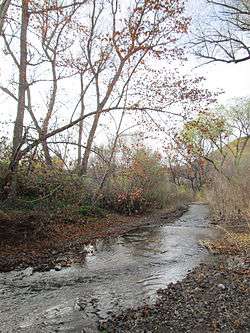
Sonoita Creek, facing downstream from Salero Road. | |
| Country | United States |
| Basin | |
| Main source | Cienega Valley |
| River mouth |
Santa Cruz River, Rio Rico, Arizona 3,435 ft (1,047 m)[1] |
| River system | Colorado River |
| Physical characteristics | |
| Length | 31 mi (50 km)[2] |
| Features | |
| Tributaries |
|
Sonoita Creek is a stream in Santa Cruz County, Arizona. It originates near and takes its name from the abandoned Pima mission in the high valley near Sonoita. It flows steadily for the first 15 miles (24 km) of its westward course past Patagonia, its bird sanctuary and Patagonia Lake, but sinks beneath the sand seven to eight miles (13 km) before joining the Santa Cruz River a few miles north of Nogales. This confluence provides water for Tumacácori and Tubac and collects in the marsh lands around San Xavier del Bac downstream, to the north. The Santa Rita Mountains lie to the north and the Canelo Hills, Red Mountain and the Patagonia Mountains lie to the south. Harshaw Creek is a southern tributary which joins the Sonoita near Patagonia. Harshaw Creek drains the area between the Patagonia Mountains to the west and the high San Rafael Valley grasslands to the east. The ghost town of Harshaw lies within its watershed.
The New Mexico and Arizona Railroad paralleled the Sonoita Creek for a portion of the railroad's route. The route ran from a connection with the Southern Pacific Railroad in Benson, then south to Fairbank (about 13 km or 8 miles west of Tombstone) then west to Sonoita - Patagonia and Rio Rico, then south to Nogales. The railroad was constructed in 1881–82 and was abandoned in five phases between 1927 and 1962. Only 15.74 km (9.78 mi) of track remains in place today, from Rio Rico to Nogales, and is operated by the Union Pacific Railroad.
 Riparian forest along Sonoita Creek, southwest of Patagonia Lake.
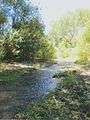 Sonoita Creek in the summer of 2014.
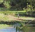 A great blue heron walking along Sonoita Creek.
See also
External links
| Wikimedia Commons has media related to Sonoita Creek. |
References
- ↑ "Sonoita Creek, AZ at Topoquest". Retrieved 2015-12-26.
- ↑ "Watershed FAQs: Sonoita Creek". Friends of Sonoita Creek. Retrieved 2014-12-26.
Coordinates: 31°39′14″N 110°42′40″W / 31.6540216°N 110.7111263°W