Silverpit crater

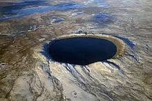
Silverpit crater is a buried sub-sea structure under the North Sea off the coast of the island of Great Britain. The 20 km crater-like form,[1][2] named after the Silver Pit — a nearby sea-floor valley recognized by generations of fishermen — was discovered during the routine analysis of seismic data collected during exploration for gas in the Southern North Sea Sedimentary Basin. Its meteor impact origin was first proposed and widely reported in 2002.[1] If correct, it would be the first impact crater identified in or near Great Britain. Its age was proposed to lie somewhere in a 29-million year interval between 74 – 45 million years (Late Cretaceous – Eocene).[3]
However, the interpretation is controversial and other authors have disputed its extraterrestrial origin. An alternative origin has been proposed in which the feature was created by withdrawal of rock support by salt mobility.[4]
Discovery

The crater-like structure was discovered by petroleum geoscientists Simon Stewart of BP and Philip Allen, then of Production Geoscience Ltd, during routine analysis of seismic data while exploring for natural gas deposits in a region 130 km off the Humber estuary. Allen noticed an unusual set of concentric rings. Although they looked as if they may have been caused by a meteor, he had no experience of impact structures. So he hung an image of them on the wall of his office, hoping someone else might be able to shed light on the mystery. Stewart, visiting Production Geoscience on an unrelated matter, had long predicted that a crater would be found on 3D seismic data, saw the image and suggested it might be an impact feature. The discovery of the crater and the impact hypothesis were reported in the journal Nature in 2002.[1]
Silverpit crater is named after the Silver Pit fishing grounds in which it is located. The name is given by fishermen to a large elongated depression in the bed of the North Sea, which is thought to be an old river valley formed while the sea level was lower during the Ice Age. The structure currently lies below a layer of sediment up to 1,500 m thick, which forms the bed of the North Sea at a depth of about 40 m. Stewart and Allen's studies suggest that at the time of its formation, the area was under 50 to 300 m of water.[1]
Only three years before the announcement of the discovery of the Silverpit crater, it had been suggested that seismic data from the North Sea would have a good chance of containing evidence of an impact crater: given the rate of crater formation on the Earth and the size of the North Sea, the expected number of impact craters would be one. Finding the crater form at Silverpit was serendipity.[5]
Origin
The origin of the crater is currently being hotly debated by the Geoscience community with alternate theories of salt withdrawal and pull-apart basin[6] proposed, raising doubts as to Silverpit's categorization as an impact structure.[7]
Evidence in favour of impact origin
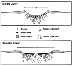
Other mechanisms for producing a crater were considered and rejected by Allen and Stewart when they discovered the crater. Volcanism was excluded because there were no magnetic anomalies in the crater, which would be expected if eruptions had occurred there. Withdrawal of salt deposits below the crater, known to be a mechanism for the formation of some craters, was ruled out because the Triassic and Permian layers of rock beneath the crater appeared to be undisturbed. Another strong indication that an impact had created the crater was the presence of a central peak - something that Stewart & Allen contend is difficult to form except through a meteorite impact.
Evidence for alternative interpretations
Analysis of regional 2D seismic lines and 3D seismic volumes by John Underhill, a geologist at the University of Edinburgh, led to the counterproposal that withdrawal of Upper Permian (Zechstein Supergroup) salt at depth was in fact a better explanation.[4] Underhill found that all layers of rock down to the Permian (with an age of about 250 million years) are synclinically folded, and that sediments of Tertiary age at the crater onlap its sides and thicken into its axis, suggesting that the salt was moving (a process called halokinesis) while Tertiary sediments were being laid down.[4]
In 2007, Underhill continued to present evidence that he argues does not support the impact hypothesis. After analyzing seismic data over a wide region, he proposed that Silverpit was just one of many similar features related to the withdrawal of the Permian-age Zechstein salt. This result was presented at the April 2007 annual meeting of the American Association of Petroleum Geologists [8]
Underhill then focused his research attention upon understanding why the salt moves where it does when it does and why the so-called crater took the form that it did. This led him to publish a peer-review article in the journal, Petroleum Geoscience[9] in August 2009 in which he outlined the evidence for an intrusion-related salt withdrawal cause for the feature's formation.
In October 2009, an open debate of the notion that "the Silverpit Crater was formed by meteor impact" was held at the Geological Society of London. Simon Stewart gave the case for the motion and John Underhill presented the case against. The outcome was overwhelming support for Underhill's alternative genesis through melt-induced salt withdrawal.[10]
Structure

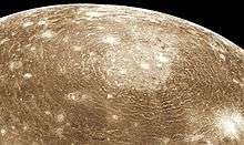
Silverpit crater is about 3 km wide at the top Cretaceous level.[3] Unusually for a terrestrial crater, it is surrounded by a set of concentric rings, which extend to about 10 km radius from the centre. These rings give the crater a somewhat similar appearance to Valhalla crater on Jupiter's moon Callisto, and other craters on Europa.[11] Normally, multi-ringed craters tend to be much larger than Silverpit, and so, if the impact hypothesis is correct, the origin of Silverpit's rings is subject to debate. A complicating factor is that almost all known impact craters are on land, despite the fact that two-thirds of impacting objects will land in oceans and seas, so the results of impacts on water are much less well established than those of impacts on land. Compare the Chesapeake Bay impact crater, probably the most thoroughly studied marine impact zone.
One possibility is that after the impact excavated a bowl-shaped depression, soft material surrounding it slumped towards the centre, leaving the concentric rings. It is thought that for this to happen, the soft material would have to be quite a thin layer, with more brittle material on top. A thin layer of mobile material beneath a solid crust is easy to understand in the context of icy moons, but is not a common occurrence on the rocky bodies of the solar system. One suggestion is that overpressured chalk below the surface may have acted as the soft mobile layer.[12]
The impact
If one assumes the meteor impact theory is right, the size of the crater can be combined with assumptions about the speed of an impacting object to estimate the size of the impactor itself. Impacting objects are generally moving at speeds of the order of 20–50 km/s, and at these speeds an object about 120 m (393 feet) across and with a mass of 2.0×10⁹ kg (2 million tonnes) would be required to form a Silverpit-sized crater, if the object was rocky. If it had been a comet, the crater would have been larger.
For comparison, the object which struck the Earth at Chicxulub is estimated to have measured approximately 9.6 km (6 miles) across, while the object responsible for the Tunguska event in 1908 is thought to have been a comet or asteroid about 60 m (196 feet) across, with a mass of about 4×10⁸ kg.[13]
An object 120 m (393 feet) across smashing into the sea at many kilometers per second would generate enormous tsunamis. Scientists are currently searching for any evidence of large tsunamis in the surrounding areas dating from around that time, but no such evidence has been uncovered yet.
Age
The position of the crater within the layers of rock and sediment on the sea floor could in theory be used to constrain its age: sediments laid down before the crater's formation might conceivably be disturbed by the impact, while those laid down afterwards will not. In their discovery paper, Allen and Stewart stated that Silverpit was formed in Cretaceous chalk and Jurassic shale, but is covered by an undisturbed layer of Tertiary sediment.[1] The Cretaceous Period ended about 66 million years ago, but, on the evidence of nearby boreholes, the lowermost Tertiary sediments appear to be absent. Thus the age of the Silverpit event was initially stated to lie somewhere between 66 and 60 million years before present. However, after a more detailed apprasial of the seismic data, Allen and Stewart gave a more cautious estimate of the age as between 74 – 45 million years (Late Cretaceous – Eocene).[3]
The stratigraphic method of estimating the age of a crater is somewhat crude and imprecise, and the result is questioned by Underhill's non-impact hypothesis.[4] Assuming an impact origin, other possible ways of dating the event include looking for evidence of ejecta material such as tektites, and deposits from the hypothesised tsunami, which might be found anywhere around the North Sea basin.[8] As well as allowing a more accurate age determination, finding such evidence would also strengthen the impact hypothesis. Two nearby oil exploration wells penetrate the ring system, yet cutting samples from these fail to provide any independent support for the meteor theory, thus weakening the case for it being due to an extraterrestrial body.
Analysis of samples taken directly from the central crater would also assist age determination as well as confirm one or other of the proposed theories; until this has occurred Silverpit cannot be confirmed as an impact structure.
Part of a multiple impact?
The early estimate of the age of the Silverpit event, stated as 66 – 60 million years before present, overlaps with the age of the Chicxulub impact, which occurred 66 million years ago and probably played a major role in the extinction of the dinosaurs. Several other large impact craters of around the same age have been discovered, all between latitudes 20°N and 70°N, leading to the speculative hypothesis that the Chicxulub impact may have been only one of several impacts that happened all at the same time.[14]
The collision of Comet Shoemaker-Levy 9 with Jupiter in 1994 proved that gravitational interactions can fragment a comet, giving rise to many impacts over a period of a few days if the comet fragments should collide with a planet. Comets frequently undergo gravitational interactions with the gas giants, and similar disruptions and collisions are very likely to have occurred in the past.
While this scenario may have occurred on Earth 66 million years ago, evidence for this hypothesis is not strong. In particular, the ages of some of the possibly related craters are only known to an accuracy of a few million years.[15] Also, the now widely held previously stated belief that Silverpit was not formed by bolide impact reduces the possibility of it being involved in this hypothesis.[16] Even if it were formed by bolide impact, the increased uncertainty in the age estimate for Silverpit to 74 – 45 million years further weakens the hypothesis.
See also
- BP Structure, an impact crater also discovered by BP.
- Doggerland, the Silverpit's area which was above sea level in human prehistory
- Impact event
- List of unconfirmed impact craters on Earth
- Mjølnir crater, an impact crater in the Barents sea which has been linked to a tsunami in southern Sweden 145 million years ago.
- Stac Fada Member (Ullapool bolide), another proposed impact crater in the British Isles
References
- 1 2 3 4 5 Stewart SA, Allen PJ (2002). "A 20-km-diameter multi-ringed impact structure in the North Sea". Nature. 418 (6897): 520–3. Bibcode:2002Natur.418..520S. doi:10.1038/nature00914. PMID 12152076.
- ↑ Stentor Danielson (2002). Unusually Well Preserved Crater Found in North Sea, National Geographic News, July 31, 2002
- 1 2 3 Stewart, S. A. & Allen, P. J. (2005). "3D seismic reflection mapping of the Silverpit multi-ringed crater, North Sea". Geological Society of America Bulletin. 117 (3): 354–368. Bibcode:2005GSAB..117..354S. doi:10.1130/B25591.1.
- 1 2 3 4 Underhill J.R. (2004). "Earth science: an alternative origin for the 'Silverpit crater'". Nature. 428 (6980): 280. Bibcode:2004Natur.428.....U. doi:10.1038/nature02476. PMID 15029895.
- ↑ Danielson, Stentor. "Unusually Well Preserved Crater Found in North Sea". news.nationalgeographic.com. Retrieved 2009-12-27.
- ↑ K. Smith (2004). "The North Sea Silverpit Crater: impact structure or pull-apart basin?". Journal of the Geological Society. 161 (4): 593–602. doi:10.1144/0016-764903-140.
- ↑ K. Thomson; P. Owen; K. Smith (2005). "Discussion on the North Sea Silverpit Crater: impact structure or pull-apart basin?". Journal of the Geological Society. 162: 217–220. doi:10.1144/0016-764904-070.
- 1 2 Fildes, Jonathan (2007-03-30). "UK impact crater debate heats up". BBC News. Retrieved 2007-03-30.
- ↑ Underhill, J.R. (2009) Role of intrusion-induced salt mobility in controlling the formation of the enigmatic "Silverpit Crater", UK Southern North Sea. Petroleum Geoscience, 15, 197–216. DOI 10.1144/1354-079309-843
- ↑ "Geological Society - Silverpit "not crater"". www.geolsoc.org.uk. Retrieved 2009-12-27.
- ↑ Allen P.J.; Stewart S.A. (2003). "Silverpit: the morphology of a terrestrial multi-ringed impact structure". Lunar and Planetary Science. XXXIV: 1351.
- ↑ Collins G.S.; Turtle E.P.; Melosh H.J. (2003). "Numerical Simulations of Silverpit Crater Collapse". Impact Cratering: Bridging the Gap Between Modeling and Observations. p. 18.
- ↑ Foschini L. (1999). "A solution for the Tunguska event". Astronomy & Astrophysics. 342: L1. arXiv:astro-ph/9808312
 . Bibcode:1999A&A...342L...1F. Abstract
 - ↑ Double space strike 'caused dinosaur extinction' http://www.bbc.co.uk/news/science-environment-11112417
- ↑ What Really Killed the Dinosaurs?:“An asteroid 65 million years ago” is no longer enough. http://www.slate.com/articles/health_and_science/animal_forecast/2013/02/dinosaur_extinction_was_an_asteroid_the_only_cause_of_the_cretaceous_mass.single.html#correction
- ↑ North Sea crater shows its scars http://news.bbc.co.uk/2/hi/science/nature/4360815.stm
External links
- UK's first impact crater discovered
- National Geographic news
- David Darling's space encyclopedia
- The Geological Society of London
- Further information from the Geological Society of London
Coordinates: 54°14′N 1°51′E / 54.233°N 1.850°E