Sierra Carapé
| Sierra Carapé | |
|---|---|
|
A rocky summit in this range of hills. | |
| Highest point | |
| Peak | Cerro Catedral (Cathedral Hill) |
| Elevation | 513.66 m (1,685.2 ft) |
| Coordinates | 34°22′55.9″S 54°40′27.7″W / 34.382194°S 54.674361°W |
| Geography | |
 | |
| Country | Uruguay |
| Range coordinates | 34°20′S 54°39′W / 34.33°S 54.65°WCoordinates: 34°20′S 54°39′W / 34.33°S 54.65°W |
| Parent range | Cuchilla Grande |
| Geology | |
| Age of rock | Precambrian |
| Type of rock | Granite, gneiss |

Sierra Carapé or Sierra de Carapé is a hill range located in Maldonado Department, in southern Uruguay. The range crosses the Maldonado Department from west to east and enters the Rocha Department. It constitutes the border between the departments of Lavalleja and Maldonado. This hill range constitutes part of a larger range named Cuchilla Grande.
Highest point in Uruguay
This range has the highest point of the country, the Cerro Catedral, with 513.66 metres (1,685.24 feet) of altitude.
See also
External links
- (Spanish) Cerro Catedral, Site of the Municipality of Maldonado, Uruguay.
- (English) Peakbagger.com: Cerro Catedral, Uruguay
Capital: | ||
| Towns and villages | 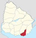 | |
| Sights | ||
This article is issued from Wikipedia - version of the 8/15/2014. The text is available under the Creative Commons Attribution/Share Alike but additional terms may apply for the media files.