Cerro Pelado
| Cerro Pelado | |
|---|---|
| Suburb of Maldonado | |
 Cerro Pelado Location in Uruguay | |
| Coordinates: 34°53′0″S 54°59′0″W / 34.88333°S 54.98333°WCoordinates: 34°53′0″S 54°59′0″W / 34.88333°S 54.98333°W | |
| Country |
|
| Department | Maldonado Department |
| Population (2011) | |
| • Total | 8,177 |
| Time zone | UTC -3 |
| Postal code | 20000 |
| Dial plan | +598 42 (+6 digits) |
| Climate | Cfb |
Cerro Pelado is a fast-growing population centre, or barrio, in the Maldonado Department of southeastern Uruguay. It is one of the northern suburbs of Maldonado, along with Villa Delia and La Sonrisa. In the 2011 census, it was the 6th biggest populated centre of the department. According to some reports, there are about 12000 inhabitants in the area of influence of this barrio.[1]
Population
In 2011 Cerro Pelado had a population of 8,177.[2]
| Year | Population |
|---|---|
| 1985 | 130 |
| 1996 | 2,407 |
| 2004 | 6,385 |
| 2011 | 8,177 |
Source: Instituto Nacional de Estadística de Uruguay[3]
References
- ↑ http://maldonadonoticias.com/el-populoso-barrio-cerro-pelado-contara-con-cajero-automatico-del-brou/
- ↑ "Censos 2011 Cuadros Maldonado". INE. 2012. Archived from the original on 10 October 2012. Retrieved 25 August 2012.
- ↑ "1963–1996 Statistics / C" (DOC). Instituto Nacional de Estadística de Uruguay. 2004. Retrieved 27 June 2011.
External links
Capital: | ||
| Towns and villages | 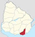 | |
| Sights | ||
This article is issued from Wikipedia - version of the 11/18/2016. The text is available under the Creative Commons Attribution/Share Alike but additional terms may apply for the media files.