Shorzha, Armenia
| Shorzha Շորժա | |
|---|---|
|
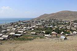
Shorzha as viewed from atop the adjacent hill with chapel ruins. | |
 Shorzha Շորժա | |
| Coordinates: 40°30′04″N 45°16′28″E / 40.50111°N 45.27444°ECoordinates: 40°30′04″N 45°16′28″E / 40.50111°N 45.27444°E | |
| Country | Armenia |
| Marz (Province) | Gegharkunik |
| Government | |
| • Mayor | Suliko Shushanyan |
| Elevation | 1,915 m (6,283 ft) |
| Population (2001) | |
| • Total | 565 |
| Time zone | GMT+4 (UTC+4) |
| Postal code | 1316 |
Shorzha (Armenian: Շորժա, also Romanized as Shorja; formerly, Nadezhdino and Shordzhalu) is a village located along Lake Sevan, northwest of the Artanish Peninsula in the Gegharkunik Province of Armenia. There is a 17th-century chapel and cemetery along the southern outskirts of the village. Upon the hill overlooking Shorzha, there are the ruins of a chapel, and somewhere in the vicinity are the remains of an Iron Age fort.[1]
Gallery
 Shorzha Village
 Shorzha as seen from the Artanish Peninsula.
 17th-century chapel at the outskirts of town.
 Chapel ruins atop a hill overlooking Shorzha.
 Shorzha train depot
References
- Shorzha, Armenia at GEOnet Names Server
- Report of the results of the 2001 Armenian Census, National Statistical Service of the Republic of Armenia
- Brady Kiesling, Rediscovering Armenia, p. 49; original archived at Archive.org, and current version online on Armeniapedia.org.
External links
| Wikimedia Commons has media related to Shorzha. |
 Shorzha travel guide from Wikivoyage

This article is issued from Wikipedia - version of the 6/17/2016. The text is available under the Creative Commons Attribution/Share Alike but additional terms may apply for the media files.