Nerkin Getashen
| Nerkin Getashen Ներքին Գետաշեն | |
|---|---|
|
The village of Nerkin Getashen. | |
 Nerkin Getashen Ներքին Գետաշեն | |
| Coordinates: 40°08′48″N 45°15′51″E / 40.14667°N 45.26417°ECoordinates: 40°08′48″N 45°15′51″E / 40.14667°N 45.26417°E | |
| Country | Armenia |
| Marz (Province) | Gegharkunik |
| Government | |
| • Mayor | Karo Gevorgyan |
| Elevation | 1,948 m (6,391 ft) |
| Population (2010) | |
| • Total | 8,016 |
| Time zone | GMT+4 (UTC+4) |
| Postal code | 1414 |
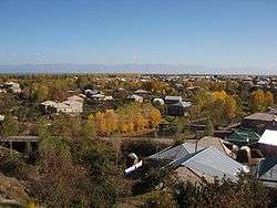
Nerkin Getashen (Armenian: Ներքին Գետաշեն, also Romanized as Nerk’in Getashen, Nerkin Getachen, and Nerqin Getashen - meaning Lower Getashen; prior to 1945, Nerkin Adyaman and Nizhniy Adyaman - both meaning Lower Adyaman) is a major village located along the southwest coast of Lake Sevan in the Gegharkunik Province of Armenia.
In the village is the 9th century monastery and church of Kotavank overlooking the village and the Argitchi River with a large cemetery adjacent. Turkic rune inscriptions are located nearby. Within the village is a ruined "Jam" or funeral chapel with khachkars built into its walls, and not far away is a small shrine. An old mill sits along the Argitchi River. There are also two large stone forts from the Middle Ages located 2 km to the east and 3 km the west of the village.
South of Nerkin Getashen lies Verin Getashen (Upper Getashen), founded 1828-29 by migrants from Mush and Alashkert, in present day Eastern Turkey.[1]
Kot
In the early Middle Ages, the site of what is now modern Nerkin Getashen served as the capital of the ancient Syunyats region, known at that time as Kot. The settlement was located along the Dvin-Partav historical trade route, which allowed it to become an important 9th-10th century trade center. It also served as a fishery for the medieval Bagratuni Kingdom of Armenia due to the large quantity of trout that were once abundant in the Argitchi River. The written record of Prince Grigor Supan notes that Kot served as the capital of his princedom. Aside from this, there is no further mention of Kot found in his writings. The monastery and church of Kotavank were also erected by Prince Grigor Supan during his reign. Both Kotavank and Kot were partially destroyed by invasions in the 10th-11th centuries and later by an earthquake. After its capture by Turkish invaders, Kot was renamed Adyaman.[2]
Gallery
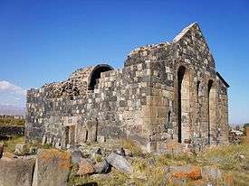 Kotavank and the adjacent cemetery (prior to renovation)
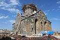 Renovation of the church, September 2014
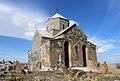 Renovation of the church, November 2014
References
- ↑ Kiesling, Brady; Kojian, Raffi (2005). Rediscovering Armenia: Guide (2nd ed.). Yerevan: Matit Graphic Design Studio. p. 79. ISBN 99941-0-121-8.
- ↑ Arzumanyan, Makich (1979). Hambardzumyan, Viktor, ed. Կոթ ("Kot"). Հայկական Սովետական Հանրագիտարան Soviet Armenian Encyclopedia (in Armenian). 5. Yerevan: Armenian Encyclopedia. pp. 506–507.
- Nerkin Getashen at GEOnet Names Server
- World Gazeteer: Armenia – World-Gazetteer.com
- Report of the results of the 2001 Armenian Census, National Statistical Service of the Republic of Armenia
