Sheridan Township, Crawford County, Kansas
| Sheridan Township | |
|---|---|
| Township | |
 Location in Crawford County | |
| Coordinates: 37°24′15″N 094°50′01″W / 37.40417°N 94.83361°WCoordinates: 37°24′15″N 094°50′01″W / 37.40417°N 94.83361°W | |
| Country | United States |
| State | Kansas |
| County | Crawford |
| Area | |
| • Total | 79.81 sq mi (206.7 km2) |
| • Land | 79.56 sq mi (206.06 km2) |
| • Water | 0.25 sq mi (0.64 km2) 0.31% |
| Elevation | 955 ft (291 m) |
| Population (2010) | |
| • Total | 1,451 |
| • Density | 18/sq mi (7.0/km2) |
| GNIS feature ID | 0469628 |
Sheridan Township is a township in Crawford County, Kansas, USA. As of the 2010 census, its population was 1,451.[1]
Geography
Sheridan Township covers an area of 79.81 square miles (206.7 km2) and contains one incorporated settlement, Cherokee. According to the USGS, it contains five cemeteries: Beulah, Cherokee, Meyers, Monmouth and Osage.
The streams of Grindstone Creek, Limestone Creek, Thunderbolt Creek and Wolf Creek run through this township.
References
- ↑ "Race, Hispanic or Latino, Age, and Housing Occupancy: 2010 Census Redistricting Data (Public Law 94-171) Summary File (QT-PL), Sheridan township, Crawford County, Kansas". U.S. Census Bureau, American FactFinder 2. Retrieved October 28, 2011.
External links
Municipalities and communities of Crawford County, Kansas, United States | ||
|---|---|---|
| Cities | 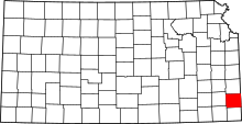 | |
| Townships | ||
| CDPs | ||
| Unincorporated communities | ||
| Footnotes | ‡This populated place also has portions in an adjacent county or counties | |
This article is issued from Wikipedia - version of the 6/22/2016. The text is available under the Creative Commons Attribution/Share Alike but additional terms may apply for the media files.