Baker Township, Crawford County, Kansas
| Baker Township | |
|---|---|
| Township | |
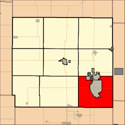 Location in Crawford County | |
| Coordinates: 37°24′24″N 094°40′28″W / 37.40667°N 94.67444°WCoordinates: 37°24′24″N 094°40′28″W / 37.40667°N 94.67444°W | |
| Country | United States |
| State | Kansas |
| County | Crawford |
| Area | |
| • Total | 56.83 sq mi (147.2 km2) |
| • Land | 56.8 sq mi (147.12 km2) |
| • Water | 0.03 sq mi (0.08 km2) 0.05% |
| Elevation | 919 ft (280 m) |
| Population (2010) | |
| • Total | 3,408 |
| • Density | 60/sq mi (23/km2) |
| GNIS feature ID | 0469616 |
Baker Township is a township in Crawford County, Kansas, USA. As of the 2010 census, its population was 3,408.[1]
Geography
Baker Township covers an area of 56.83 square miles (147.2 km2) surrounding the city of Pittsburg. According to the USGS, it contains three cemeteries: Dietz, Frontenac and West Union.
The streams East Cow Creek, First Cow Creek and Second Cow Creek run through this township.
References
- ↑ "Race, Hispanic or Latino, Age, and Housing Occupancy: 2010 Census Redistricting Data (Public Law 94-171) Summary File (QT-PL), Baker township, Crawford County, Kansas". U.S. Census Bureau, American FactFinder 2. Archived from the original on September 11, 2013. Retrieved October 28, 2011.
External links
Municipalities and communities of Crawford County, Kansas, United States | ||
|---|---|---|
| Cities | 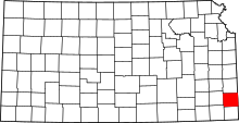 | |
| Townships | ||
| CDPs | ||
| Unincorporated communities | ||
| Footnotes | ‡This populated place also has portions in an adjacent county or counties | |
This article is issued from Wikipedia - version of the 10/24/2016. The text is available under the Creative Commons Attribution/Share Alike but additional terms may apply for the media files.