Sharps Island Light
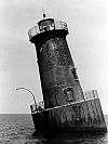
 Sharps Island Light, 2009 | |
  | |
| Location | SW of Tilghman Island, Chesapeake Bay, Maryland |
|---|---|
| Coordinates | 38°38′21″N 76°22′33″W / 38.6391°N 76.3757°WCoordinates: 38°38′21″N 76°22′33″W / 38.6391°N 76.3757°W |
| Year first lit | 1838 (original), 1866 (second), 1882 (current) |
| Automated | 1938 |
| Deactivated | 2010 |
| Foundation | Concrete caisson |
| Construction | Cast iron |
| Tower shape | Frustum of a cone |
| Height | 35 feet (11 m) |
| Original lens | Fourth-order Fresnel |
| Current lens |
9.8 inches (250 mm) acrylic |
|
Sharps Island Light | |
| Nearest city | Tilghman Island, Maryland |
| Area | 5 acres (2.0 ha) |
| Built | 1882 |
| NRHP Reference # | 82002821[1] |
| Added to NRHP | July 22, 1982 |
The Sharps Island Light is the third lighthouse to stand nearly 3 miles (5 km) south-southwest from the southern end of Tilghman Island in Maryland's Chesapeake Bay.[2] The structure is best known today for evoking the Leaning Tower of Pisa, a condition caused by an ice floe in 1977.
The first lighthouse was built on Sharps Island in 1838, but due to the island's erosion it was moved in 1848. This was replaced with a screwpile lighthouse in 1866 near the original location of the first structure.[3][4]
The second lighthouse lasted until 1881 when it was forced off its foundations by an ice floe. It floated nearly five miles down the Chesapeake—with its keepers still inside—until it ran aground, allowing the men to escape unharmed.[5]
The current light, a sparkplug lighthouse, was constructed in 1882 with a concrete caisson foundation and a 35-foot (11 m) cast iron tower. The fourth-order Fresnel lens was replaced with a 9.8-inch (250 mm) lens in 1977; the focal plane is 54 feet (16 m) above sea level. The tower includes an integral dwelling and was manned until 1938 when the United States Coast Guard automated the light.[3] Leaning by about 15° since it was ice-damaged in 1977, the structure is picturesque, but in poor condition.
The Sharps Island Light was listed on the National Register of Historic Places (reference # 82002821) on July 22, 1982.[1] It is one of the many historic features along Captain John Smith Chesapeake National Historic Trail.
It is also on the Lighthouse Digest Doomsday List of endangered lighthouses.[6]
As of 2006, the lighthouse was a candidate for sale under the National Historic Lighthouse Preservation Act.[6][7] It was deactivated in January 2010.[8]

References
- 1 2 National Park Service (2010-07-09). "National Register Information System". National Register of Historic Places. National Park Service.
- ↑ Anderson, Kraig Lighthouse friends. "Sharps Island Light". Retrieved January 11, 2007.
- 1 2 National Park Service, Maritime History Project,. "Inventory of Historic Light Stations: Sharps Island Light". Retrieved January 11, 2007.
- ↑ D. M. Hanley (n.d.). "National Register of Historic Places Registration: Sharps Island Light" (PDF). Maryland Historical Trust. Retrieved 2016-03-01.
- ↑ Chesapeake Chapter: United States Lighthouse Society. "Sharps Island Lighthouse". Retrieved January 11, 2007.
- 1 2 Rowlett, Russ. "Lighthouses of the United States: Maryland". The Lighthouse Directory. University of North Carolina at Chapel Hill.
- ↑ National Historic Lighthouse Preservation Act of 2000.
- ↑ "Local Notice to Mariners District 5 Week 02/10" (PDF). United States Coast Guard. 12 January 2010. p. 24. Retrieved 2010-12-05.
Further reading
- Hanks, Douglas, Coast Guard Eyes Lighthouse for Demolition Officials say, Sharp's Island beacon may cost more than it's worth (March, 1996) Lighthouse Digest.
External links
- Aerial photographs at Marinas.com.
- Chesapeake Bay Gateways Network, Sharps Island Light.
- Chesapeake Lights, U.S. Lighthouse Society, Sharps Island Light including timeline.
- Chesapeake Bay Lighthouse Project - Sharps Island Light
| Topics |  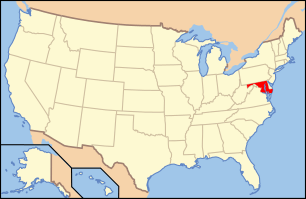 | |
|---|---|---|
| Lists by county | ||
| Lists by city | ||
| Other lists | ||
| ||