Sandy Point Shoal Light
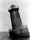
 1885 photograph of Sandy Point Light (USCG) | |
  | |
| Location | off Sandy Point near the west end of the Chesapeake Bay Bridge |
|---|---|
| Coordinates | 39°00′58″N 76°23′04″W / 39.016°N 76.3845°WCoordinates: 39°00′58″N 76°23′04″W / 39.016°N 76.3845°W |
| Year first constructed | 1883 |
| Year first lit | 1883 |
| Automated | 1963 |
| Foundation | caisson |
| Construction | brick/wood-frame |
| Tower shape | octagonal mansard roof house |
| Markings / pattern | Red brick with white roof and brown foundation |
| Focal height | 51 feet (16 m) |
| Original lens | fourth-order Fresnel lens |
| Current lens | solar-powered |
| Range | 9 nautical miles (17 km; 10 mi) |
| Characteristic | Flashing white 6 sec |
| Fog signal | none |
| Admiralty number | J2214 |
| ARLHS number | USA-733 |
| USCG number | |
|
Sandy Point Shoal Light Station | |
| Nearest city | Skidmore, Maryland |
| Area | less than one acre |
| MPS | Light Stations of the United States MPS |
| NRHP Reference # | 02001424[4] |
| Added to NRHP | December 2, 2002 |
Sandy Point Shoal Light is a brick three story lighthouse on a caisson foundation that was erected in 1883.[1] It lies about 0.6 mi (0.97 km) off Sandy Point, north of the Chesapeake Bay Bridge, from whose westbound span it is readily visible.
The current light replaced a brick tower on the point itself, integral to the keeper's house, which was erected in 1857. By 1874 the Lighthouse Board complained that the extent of the shoal and the poor equipment of the lighthouse made a new light necessary; appropriations were not forthcoming, however, until 1882. The whole gamut of light sources has been run, from oil wicks to incandescent oil vapor (1913) to electricity (1929). The characteristic changed from flashing to fixed and back to flashing along with the change in light source. The present light is powered by a pair of solar panels attached to the roof on the south side.[5]
After automation in 1963, the light became subject to vandalism due to its visibility and its accessibility. The original lens was destroyed in 1979, apparently smashed with a baseball bat.[1] Though the Coast Guard made efforts at maintaining and restoring the structure from 1988 to 1990, it continued to deteriorate. In 2006 it was sold at auction to a private bidder, after an unsuccessful attempt to find a non-profit group to take responsibility for the light. The Coast Guard continues to maintain the navigation aids. The structure was added to the National Register of Historic Places as Sandy Point Shoal Light Station on December 2, 2002.[4]
Notes
- 1 2 3 "Historic Light Station Information and Photography: Maryland". United States Coast Guard Historian's Office.
- ↑ Light List, Volume II, Atlantic Coast, Shrewsbury River, New Jersey to Little River, South Carolina (PDF). Light List. United States Coast Guard. 2012. p. 76.
- ↑ Rowlett, Russ. "Lighthouses of the United States: Maryland". The Lighthouse Directory. University of North Carolina at Chapel Hill.
- 1 2 National Park Service (2010-07-09). "National Register Information System". National Register of Historic Places. National Park Service.
- ↑ Ralph E. Eshelman (January 1996). "National Register of Historic Places Registration: Sandy Point Shoal Light" (PDF). Maryland Historical Trust. Retrieved 2016-01-01.
References


- Sandy Point Shoal, MD at lighthousefriends.com
- Sandy Point Light from the Chesapeake Chapter of the U.S. Lighthouse Society
- de Gast, Robert (1973). The Lighthouses of the Chesapeake. Baltimore: Johns Hopkins University Press. pp. 83–86.
- Chesapeake Bay Lighthouse Project - Sandy Point Shoal Light
External links
- Sandy Point Shoal Light Station, Anne Arundel County, including photo from 1991, at Maryland Historical Trust
| Wikimedia Commons has media related to Sandy Point Shoal Light. |
| Topics |   | |
|---|---|---|
| Lists by county | ||
| Lists by city | ||
| Other lists | ||
| ||