| [3] |
Name on the Register[4] |
Image |
Date listed[5] |
Location |
City or town |
Description |
|---|
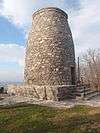
| 1 |
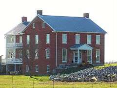
Antietam Furnace Complex Archeological Site |
|
000000001983-08-25-0000August 25, 1983
(#83002963) |
Address Restricted
|
Hagerstown |
|
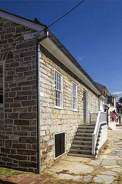
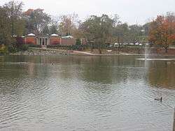
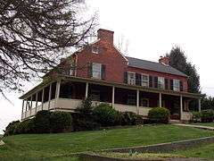
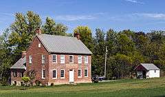
| 2 |
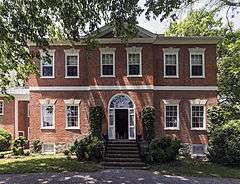
Antietam Hall |
Upload image |
000000001979-09-24-0000September 24, 1979
(#79003269) |
525 Indian Lane
39°38′12″N 77°40′55″W / 39.636667°N 77.681944°W / 39.636667; -77.681944 (Antietam Hall) |
Hagerstown |
|
| 3 |
Antietam Iron Furnace Site and Antietam Village |
|
000000001975-06-26-0000June 26, 1975
(#75000149) |
Confluence of Antietam Creek and the Potomac River
39°25′01″N 77°44′33″W / 39.416944°N 77.7425°W / 39.416944; -77.7425 (Antietam Iron Furnace Site and Antietam Village) |
Antietam |
|
| 4 |
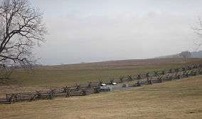
Antietam National Battlefield |
|
000000001966-10-15-0000October 15, 1966
(#66000038) |
North of Sharpsburg off Maryland Route 45
39°27′04″N 77°41′09″W / 39.451111°N 77.685833°W / 39.451111; -77.685833 (Antietam National Battlefield) |
Sharpsburg |
Civil War battlefield site.
|
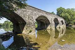
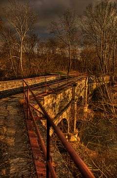
| 5 |
B&O Bridge |
|
000000001977-11-23-0000November 23, 1977
(#77000704) |
Northwest of Keedysville over Antietam Creek
39°30′15″N 77°42′49″W / 39.504167°N 77.713611°W / 39.504167; -77.713611 (B&O Bridge) |
Keedysville |
|
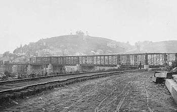
| 6 |
B & O Railroad Potomac River Crossing |
|
000000001978-02-14-0000February 14, 1978
(#78001484) |
At the confluence of the Shenandoah and Potomac rivers
39°19′27″N 77°43′43″W / 39.324167°N 77.728611°W / 39.324167; -77.728611 (B & O Railroad Potomac River Crossing) |
Harpers Ferry |
|
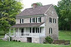
| 7 |
Baker Farm |
Upload image |
000000001978-10-19-0000October 19, 1978
(#78001485) |
North of Keedysville off Maryland Route 34
39°29′53″N 77°41′42″W / 39.498056°N 77.695°W / 39.498056; -77.695 (Baker Farm) |
Keedysville |
|
| 8 |
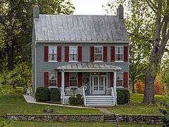
Bell-Varner House |
|
000000001979-09-24-0000September 24, 1979
(#79003271) |
Southeast of Leitersburg on Unger Rd.
39°40′04″N 77°36′26″W / 39.667778°N 77.607222°W / 39.667778; -77.607222 (Bell-Varner House) |
Leitersburg |
|
| 9 |
Boonsboro Historic District |
|
000000002005-12-23-0000December 23, 2005
(#05001431) |
Main St., Potomac St., St. Paul St., High St., Lakin Ave., Center St., Park Dr., Park Ln, Park View, and Young Ave.
39°30′22″N 77°39′09″W / 39.506111°N 77.6525°W / 39.506111; -77.6525 (Boonsboro Historic District) |
Boonsboro |
|
| 10 |
Bowman House |
|
000000001977-04-29-0000April 29, 1977
(#77000702) |
323 N. Main St.
39°30′42″N 77°39′18″W / 39.51174°N 77.65497°W / 39.51174; -77.65497 (Bowman House) |
Boonsboro |
|
| 11 |
Brightwood |
Upload image |
000000001974-07-30-0000July 30, 1974
(#74000973) |
North of Hagerstown off Maryland Route 60, 2 miles (3.2 km) north of Paramont
39°41′56″N 77°40′43″W / 39.698889°N 77.678611°W / 39.698889; -77.678611 (Brightwood) |
Hagerstown |
|
| 12 |
Cedar Grove |
Upload image |
000000001999-08-27-0000August 27, 1999
(#99000984) |
15435 Dellinger Rd.
39°32′07″N 77°50′07″W / 39.535278°N 77.835278°W / 39.535278; -77.835278 (Cedar Grove) |
Williamsport |
|
| 13 |
William Chapline House |
|
000000001976-10-08-0000October 8, 1976
(#76001020) |
109 W. Main St.
39°27′29″N 77°44′59″W / 39.458056°N 77.749722°W / 39.458056; -77.749722 (William Chapline House) |
Sharpsburg |
|
| 14 |
Chesapeake and Ohio Canal National Historical Park |
|
000000001966-10-15-0000October 15, 1966
(#66000036) |
Bordering the Potomac River from Georgetown, Washington, D.C. to Cumberland, Maryland
39°35′53″N 77°49′40″W / 39.598147°N 77.827693°W / 39.598147; -77.827693 (Chesapeake and Ohio Canal National Historical Park) |
Antietam, Cedar Grove, Hancock, and Sharpsburg |
|
| 15 |
Robert Clagett Farm |
Upload image |
000000001999-06-05-0000June 5, 1999
(#99000132) |
Garrett's Mill Rd.
39°21′03″N 77°41′06″W / 39.350833°N 77.685°W / 39.350833; -77.685 (Robert Clagett Farm) |
Knoxville |
|
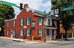
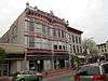
| 16 |
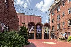
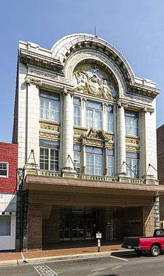
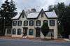
Colonial Theatre |
|
000000001978-08-02-0000August 2, 1978
(#78001478) |
12-14 S. Potomac St.
39°38′28″N 77°43′13″W / 39.641111°N 77.720278°W / 39.641111; -77.720278 (Colonial Theatre) |
Hagerstown |
|
| 17 |
Ditto Knolls |
|
000000001976-07-12-0000July 12, 1976
(#76001014) |
East of Hagerstown on Landis Rd.
39°36′23″N 77°39′45″W / 39.60644°N 77.6626°W / 39.60644; -77.6626 (Ditto Knolls) |
Hagerstown |
|
| 18 |
Daniel Donnelly House |
Upload image |
000000002003-12-24-0000December 24, 2003
(#03001333) |
14906 Falling Waters Rd.
39°33′23″N 77°51′15″W / 39.556389°N 77.854167°W / 39.556389; -77.854167 (Daniel Donnelly House) |
Williamsport |
|
| 19 |
Dorsey-Palmer House |
|
000000001978-04-15-0000April 15, 1978
(#78001479) |
North of Hagerstown on Maryland Route 60
39°40′41″N 77°41′02″W / 39.678056°N 77.683889°W / 39.678056; -77.683889 (Dorsey-Palmer House) |
Hagerstown |
|
| 20 |
Doub Farm |
Upload image |
000000001978-11-15-0000November 15, 1978
(#78001486) |
North of Keedysville
39°29′37″N 77°41′51″W / 39.493611°N 77.6975°W / 39.493611; -77.6975 (Doub Farm) |
Keedysville |
|
| 21 |
Doub's Mill Historic District |
|
000000001979-10-01-0000October 1, 1979
(#79003270) |
Southwest of Beaver Creek on Beaver Creek Rd.
39°34′43″N 77°39′18″W / 39.578611°N 77.655°W / 39.578611; -77.655 (Doub's Mill Historic District) |
Beaver Creek |
|
| 22 |
Elliot-Bester House |
|
000000001975-05-02-0000May 2, 1975
(#75000924) |
205-207 S. Potomac St.
39°38′19″N 77°43′22″W / 39.638611°N 77.722778°W / 39.638611; -77.722778 (Elliot-Bester House) |
Hagerstown |
|
| 23 |
Elmwood |
|
000000002012-12-26-0000December 26, 2012
(#12001085) |
16311 Kendle Rd.
39°35′10″N 77°48′06″W / 39.586095°N 77.801723°W / 39.586095; -77.801723 (Elmwood) |
Williamsport vicinity |
|
| 24 |
Joseph Fiery House |
Upload image |
000000002002-12-27-0000December 27, 2002
(#02001588) |
15107 Hicksville Rd.
39°42′06″N 77°50′49″W / 39.701667°N 77.846944°W / 39.701667; -77.846944 (Joseph Fiery House) |
Clear Spring |
|
| 25 |
Fort Frederick |
|
000000001973-11-07-0000November 7, 1973
(#73000939) |
Southeast of Big Pool near the junction of Maryland Routes of 44 and 56
39°36′33″N 78°01′17″W / 39.609167°N 78.021389°W / 39.609167; -78.021389 (Fort Frederick) |
Big Pool |
|
| 26 |
Jacob M. Funk Farm |
|
000000002010-10-14-0000October 14, 2010
(#10000829) |
21116 Black Rock Road
39°34′49″N 77°37′58″W / 39.580278°N 77.632778°W / 39.580278; -77.632778 (Jacob M. Funk Farm) |
Hagerstown vicinity |
|
| 27 |
Funkstown Historic District |
|
000000002000-09-08-0000September 8, 2000
(#00001050) |
Roughly bounded by Antietam Creek, U.S. Route 40A, Stouffer Ave., and High St.
39°36′30″N 77°42′36″W / 39.608333°N 77.71°W / 39.608333; -77.71 (Funkstown Historic District) |
Funkstown |
|
| 28 |
Garden Hill |
|
000000002002-12-27-0000December 27, 2002
(#02001590) |
1251 Frederick St.
39°36′49″N 77°42′45″W / 39.613611°N 77.7125°W / 39.613611; -77.7125 (Garden Hill) |
Hagerstown |
|
| 29 |
Geeting Farm |
Upload image |
000000001977-11-25-0000November 25, 1977
(#77000705) |
South of Keedysville at Geeting and Dog Rds.
39°28′40″N 77°41′54″W / 39.477778°N 77.698333°W / 39.477778; -77.698333 (Geeting Farm) |
Keedysville |
|
| 30 |
Good-Hartle Farm |
|
000000001999-12-09-0000December 9, 1999
(#99001543) |
13357 Little Antietam Rd.
39°40′52″N 77°37′41″W / 39.681111°N 77.628056°W / 39.681111; -77.628056 (Good-Hartle Farm) |
Hagerstown |
|
| 31 |
Good-Reilly House |
|
000000002002-12-30-0000December 30, 2002
(#02001591) |
107 E. Main St.
39°27′30″N 77°44′55″W / 39.458333°N 77.748611°W / 39.458333; -77.748611 (Good-Reilly House) |
Sharpsburg |
|
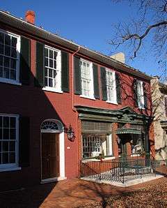
| 32 |
Hager House |
|
000000001974-11-05-0000November 5, 1974
(#74000974) |
19 Key St.
39°38′22″N 77°43′50″W / 39.639444°N 77.730556°W / 39.639444; -77.730556 (Hager House) |
Hagerstown |
|
| 33 |
William Hagerman Farmstead |
Upload image |
000000002002-12-27-0000December 27, 2002
(#02001592) |
7207 Dam #4 Rd.
39°30′41″N 77°49′00″W / 39.511389°N 77.816667°W / 39.511389; -77.816667 (William Hagerman Farmstead) |
Sharpsburg |
|
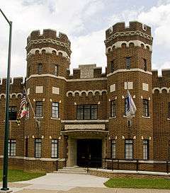
| 34 |
Hagerstown Armory |
|
000000001985-09-25-0000September 25, 1985
(#85002673) |
328 N. Potomac St.
39°38′47″N 77°43′00″W / 39.646389°N 77.716667°W / 39.646389; -77.716667 (Hagerstown Armory) |
Hagerstown |
|
| 35 |
Hagerstown Charity School |
|
000000001982-12-16-0000December 16, 1982
(#82001601) |
102 E. Washington St.
39°38′26″N 77°43′05″W / 39.640556°N 77.718056°W / 39.640556; -77.718056 (Hagerstown Charity School) |
Hagerstown |
|
| 36 |
Hagerstown City Park Historic District |
|
000000001990-07-05-0000July 5, 1990
(#90001017) |
Roughly bounded by W. Howard St., Guilford Ave., Memorial, S. Walnut St., and the Norfolk & Western railroad line
39°38′10″N 77°43′50″W / 39.636111°N 77.730556°W / 39.636111; -77.730556 (Hagerstown City Park Historic District) |
Hagerstown |
|
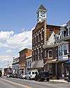
| 37 |
Hagerstown Commercial Core Historic District |
|
000000001983-01-17-0000January 17, 1983
(#83002964) |
Potomac, Washington, Franklin, Antietam, Summit, and Jonathan Sts.
39°38′33″N 77°43′18″W / 39.6425°N 77.721667°W / 39.6425; -77.721667 (Hagerstown Commercial Core Historic District) |
Hagerstown |
|
| 38 |
Hagerstown Historic District |
|
000000001994-02-02-0000February 2, 1994
(#93001551) |
Roughly bounded by Prospect and Cannon Aves., Memorial Boulevard, and the CSX railroad line
39°38′23″N 77°43′06″W / 39.639722°N 77.718333°W / 39.639722; -77.718333 (Hagerstown Historic District) |
Hagerstown |
|
| 39 |
Harpers Ferry National Historical Park |
|
000000001966-10-15-0000October 15, 1966
(#66000041) |
At the confluence of the Shenandoah and Potomac rivers
39°18′59″N 77°43′09″W / 39.316389°N 77.719167°W / 39.316389; -77.719167 (Harpers Ferry National Historical Park) |
Harpers Ferry |
|
| 40 |
Joseph C. Hays House |
|
000000002006-12-12-0000December 12, 2006
(#06001125) |
103-105 W. Main St.
39°27′30″N 77°44′58″W / 39.45829°N 77.74932°W / 39.45829; -77.74932 (Joseph C. Hays House) |
Sharpsburg |
|
| 41 |
Jacob Highbarger House |
|
000000002002-12-27-0000December 27, 2002
(#02001593) |
201 W. Main St.
39°27′27″N 77°45′06″W / 39.45757°N 77.75161°W / 39.45757; -77.75161 (Jacob Highbarger House) |
Sharpsburg |
|
| 42 |
Hills, Dales and The Vinyard |
|
000000002000-12-01-0000December 1, 2000
(#00001460) |
16 Dogstreet Rd.
39°29′00″N 77°42′25″W / 39.483333°N 77.706944°W / 39.483333; -77.706944 (Hills, Dales and The Vinyard) |
Keedysville |
|
| 43 |
Hitt's Mill and Houses |
Upload image |
000000001979-04-12-0000April 12, 1979
(#79001147) |
West of Keedysville off Maryland Route 34
39°29′06″N 77°42′44″W / 39.485°N 77.712222°W / 39.485; -77.712222 (Hitt's Mill and Houses) |
Keedysville |
|
| 44 |
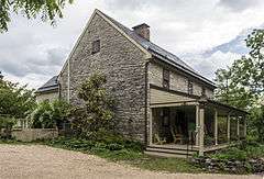
Hoffman Farm |
|
000000001997-10-10-0000October 10, 1997
(#97001183) |
18651 Keedysville Rd.
39°29′53″N 77°43′19″W / 39.498056°N 77.721944°W / 39.498056; -77.721944 (Hoffman Farm) |
Keedysville |
|
| 45 |
Hogmire-Berryman Farm |
Upload image |
000000001980-03-28-0000March 28, 1980
(#80001842) |
North of Spielman off Maryland Route 63
39°32′32″N 77°46′00″W / 39.542222°N 77.766667°W / 39.542222; -77.766667 (Hogmire-Berryman Farm) |
Spielman |
|
| 46 |
Houses At 16-22 East Lee Street |
|
000000001977-11-25-0000November 25, 1977
(#77000703) |
16-22 E. Lee St.
39°38′12″N 77°43′19″W / 39.636667°N 77.721944°W / 39.636667; -77.721944 (Houses At 16-22 East Lee Street) |
Hagerstown |
|
| 47 |
Huckleberry Hall |
Upload image |
000000001990-12-28-0000December 28, 1990
(#90001994) |
Charles Mill Rd., west of its junction with Maryland Route 64
39°41′18″N 77°35′27″W / 39.688333°N 77.590833°W / 39.688333; -77.590833 (Huckleberry Hall) |
Leitersburg |
|
| 48 |
Ingram-Schipper Farm |
Upload image |
000000001979-09-24-0000September 24, 1979
(#79003259) |
Mapleville Road (MD 66), North of Boonsboro
39°33′46″N 77°39′37″W / 39.562778°N 77.660278°W / 39.562778; -77.660278 (Ingram-Schipper Farm) |
Boonsboro |
|
| 49 |
Kennedy Farm |
|
000000001973-11-07-0000November 7, 1973
(#73000941) |
Chestnut Grove Rd.
39°22′47″N 77°42′56″W / 39.379722°N 77.715556°W / 39.379722; -77.715556 (Kennedy Farm) |
Samples Manor |
Known as John Brown's Headquarters.
|
| 50 |
Keedy House |
|
000000001974-07-25-0000July 25, 1974
(#74000972) |
Northwest of Boonsboro off U.S. Route 40A on Barnes Rd.
39°32′22″N 77°41′55″W / 39.53956°N 77.69858°W / 39.53956; -77.69858 (Keedy House) |
Boonsboro |
|
| 51 |
Keedysville Historic District |
|
000000002001-10-26-0000October 26, 2001
(#01001183) |
Along Main St.
39°29′12″N 77°41′56″W / 39.486667°N 77.698889°W / 39.486667; -77.698889 (Keedysville Historic District) |
Keedysville |
|
| 52 |
Kefauver Place |
Upload image |
000000002005-08-26-0000August 26, 2005
(#05000908) |
20515 Park Hall Rd.
39°27′01″N 77°39′14″W / 39.450278°N 77.653889°W / 39.450278; -77.653889 (Kefauver Place) |
Rohrersville |
|
| 53 |
Lantz-Zeigler House |
|
000000001998-10-08-0000October 8, 1998
(#98001231) |
21000 Leitersburg Pike
39°41′20″N 77°38′17″W / 39.688889°N 77.638056°W / 39.688889; -77.638056 (Lantz-Zeigler House) |
Hagerstown |
|
| 54 |
Lehman's Mill Historic District |
|
000000001991-01-04-0000January 4, 1991
(#90001945) |
Lehman's Mill Rd. between Marsh Pike and Marsh Run
39°42′41″N 77°40′34″W / 39.711389°N 77.676111°W / 39.711389; -77.676111 (Lehman's Mill Historic District) |
Hagerstown |
|
| 55 |
Leitersburg Historic District |
|
000000002003-12-19-0000December 19, 2003
(#03001295) |
Leitersburg-Smithsburg Rd., Leiter St., Leiter's Mill Rd., and Ringgold St.
39°41′42″N 77°37′15″W / 39.695°N 77.620833°W / 39.695; -77.620833 (Leitersburg Historic District) |
Leitersburg |
|
| 56 |
Long Meadows |
Upload image |
000000001978-09-01-0000September 1, 1978
(#78001480) |
North of Hagerstown on Marsh Pike
39°41′41″N 77°41′08″W / 39.694722°N 77.685556°W / 39.694722; -77.685556 (Long Meadows) |
Hagerstown |
|
| 57 |
Magnolia Plantation |
Upload image |
000000001975-06-18-0000June 18, 1975
(#75000926) |
Northwest of Knoxville off Sandy Hook Rd.
39°20′57″N 77°41′34″W / 39.349167°N 77.692778°W / 39.349167; -77.692778 (Magnolia Plantation) |
Knoxville |
|
| 58 |
Mannheim |
Upload image |
000000001979-09-25-0000September 25, 1979
(#79003260) |
San Mar Rd.
39°33′19″N 77°37′51″W / 39.555278°N 77.630833°W / 39.555278; -77.630833 (Mannheim) |
San Mar |
|
| 59 |
The Maples |
Upload image |
000000001975-02-24-0000February 24, 1975
(#75000927) |
2 miles (3.2 km) southwest of Smithsburg on Maryland Route 66
39°37′23″N 77°39′38″W / 39.62306°N 77.660556°W / 39.62306; -77.660556 (The Maples) |
Smithsburg |
|
| 60 |
Marsh Mills |
Upload image |
000000001996-11-22-0000November 22, 1996
(#96001375) |
17426 and 17432 Spielman Rd.
39°32′22″N 77°45′44″W / 39.539444°N 77.762222°W / 39.539444; -77.762222 (Marsh Mills) |
Fairplay |
|
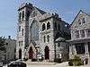
| 61 |
Maryland Theatre |
|
000000001976-11-13-0000November 13, 1976
(#76001015) |
21-23 S. Potomac St.
39°38′29″N 77°43′17″W / 39.641389°N 77.721389°W / 39.641389; -77.721389 (Maryland Theatre) |
Hagerstown |
|
| 62 |
Henry McCauley Farm |
|
000000001976-06-29-0000June 29, 1976
(#76001016) |
East of Hagerstown on Mt. Aetna Rd.
39°36′53″N 77°39′46″W / 39.61472°N 77.66278°W / 39.61472; -77.66278 (Henry McCauley Farm) |
Hagerstown |
|
| 63 |
Mount Airy |
|
000000001986-07-10-0000July 10, 1986
(#86001550) |
Maryland Route 34
39°26′55″N 77°46′04″W / 39.448611°N 77.767778°W / 39.448611; -77.767778 (Mount Airy) |
Sharpsburg |
|
| 64 |
Nicodemus Mill Complex |
Upload image |
000000002001-08-02-0000August 2, 2001
(#01000821) |
20019 Nicodemus Mill Rd.
39°28′34″N 77°40′24″W / 39.476111°N 77.673333°W / 39.476111; -77.673333 (Nicodemus Mill Complex) |
Keedysville |
|
| 65 |
Oak Hill Historic District |
Upload image |
000000001987-09-18-0000September 18, 1987
(#87001574) |
Roughly bounded by W. Irvin, Potomac, and Prospect Aves. and Forest Dr.
39°39′18″N 77°42′38″W / 39.655°N 77.710556°W / 39.655; -77.710556 (Oak Hill Historic District) |
Hagerstown |
|
| 66 |
Old Forge Farm |
|
000000001979-11-07-0000November 7, 1979
(#79001145) |
East of Hagerstown
39°40′02″N 77°38′58″W / 39.667222°N 77.649444°W / 39.667222; -77.649444 (Old Forge Farm) |
Hagerstown |
|
| 67 |
Old National Pike Milestones |
|
000000001975-11-27-0000November 27, 1975
(#75002107) |
Maryland Routes 44 and 165, U.S. Route 40, Alternate U.S. Route 40, and Scenic U.S. Route 40
39°25′13″N 77°16′01″W / 39.420278°N 77.266944°W / 39.420278; -77.266944 (Old National Pike Milestones) |
Hancock |
|
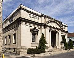
| 68 |
Old Washington County Library |
|
000000001978-10-02-0000October 2, 1978
(#78001481) |
21 Summit Ave.
39°38′34″N 77°43′24″W / 39.64268°N 77.72329°W / 39.64268; -77.72329 (Old Washington County Library) |
Hagerstown |
|
| 69 |
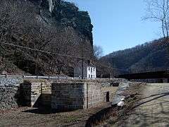
Packhouse Ford |
Upload image |
000000002015-06-15-0000June 15, 2015
(#15000349) |
Potomac R. at Canal Rd.
39°25′51″N 77°46′35″W / 39.4307°N 77.7765°W / 39.4307; -77.7765 (Packhouse Ford) |
Sharpsburg vicinity |
A historic river crossing of the Potomac River.
|
| 69 |
Paradise Manor |
|
000000001978-03-31-0000March 31, 1978
(#78001482) |
North of Hagerstown at 2550 Paradise Dr.
39°41′49″N 77°42′03″W / 39.696944°N 77.700833°W / 39.696944; -77.700833 (Paradise Manor) |
Hagerstown |
|
| 70 |
Piper House |
|
000000001999-10-28-0000October 28, 1999
(#99001279) |
200 E. Main St.
39°27′31″N 77°44′45″W / 39.458611°N 77.745833°W / 39.458611; -77.745833 (Piper House) |
Sharpsburg |
|
| 71 |
Plumb Grove |
|
000000002011-12-07-0000December 7, 2011
(#11000882) |
12654 Broadfording Rd.
39°39′40″N 77°56′11″W / 39.661032°N 77.936432°W / 39.661032; -77.936432 (Plumb Grove) |
Clear Spring vicinity |
|
| 72 |
Potomac-Broadway Historic District |
|
000000001990-12-12-0000December 12, 1990
(#90001804) |
Roughly Potomac St. and Oak Hill Ave. from Franklin St. to Maple Ave., and North Ave. and Broadway from Park Pl. to Mulberry
39°38′54″N 77°42′53″W / 39.648333°N 77.714722°W / 39.648333; -77.714722 (Potomac-Broadway Historic District) |
Hagerstown |
|
| 73 |
Potomac Mills |
Upload image |
000000002014-02-05-0000February 5, 2014
(#13001166) |
River & Trough Rds.
39°25′50″N 77°46′53″W / 39.430608°N 77.781267°W / 39.430608; -77.781267 (Potomac Mills) |
Shepherdstown |
|
| 74 |
Price-Miller House |
|
000000001976-05-24-0000May 24, 1976
(#76001018) |
131-135 W. Washington St.
39°38′37″N 77°43′25″W / 39.6437°N 77.7237°W / 39.6437; -77.7237 (Price-Miller House) |
Hagerstown |
|
| 75 |
Rockland Farm |
|
000000001978-07-21-0000July 21, 1978
(#78001483) |
728 Antietam Dr.
39°39′21″N 77°41′20″W / 39.65578°N 77.68884°W / 39.65578; -77.68884 (Rockland Farm) |
Hagerstown |
|
| 76 |
Rockledge |
|
000000002003-12-18-0000December 18, 2003
(#03001292) |
13535 Foxfire Ln.
39°41′20″N 77°36′45″W / 39.688889°N 77.6125°W / 39.688889; -77.6125 (Rockledge) |
Hagerstown |
|
| 77 |
Rohrer House |
|
000000001979-11-07-0000November 7, 1979
(#79001146) |
East of Hagerstown
39°39′25″N 77°39′40″W / 39.656944°N 77.661111°W / 39.656944; -77.661111 (Rohrer House) |
Hagerstown |
|
| 78 |
Rose Hill |
|
000000001973-04-11-0000April 11, 1973
(#73000942) |
0.5 miles (0.80 km) south of Williamsport on Maryland Route 63
39°34′41″N 77°49′08″W / 39.578056°N 77.818889°W / 39.578056; -77.818889 (Rose Hill) |
Williamsport |
|
| 79 |
Search Well |
Upload image |
000000001983-01-17-0000January 17, 1983
(#83002965) |
Southeast of Burtner on Manor Church Rd.
39°31′12″N 77°42′49″W / 39.52°N 77.713611°W / 39.52; -77.713611 (Search Well) |
Burtner |
|
| 80 |
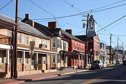
Sharpsburg Historic District |
|
000000002008-12-24-0000December 24, 2008
(#08001218) |
E. and W. Chapline, Antietam, and High Sts. and N. and S. Church, Mechanic, Hall, and Potomac Sts.
39°27′27″N 77°44′56″W / 39.4575°N 77.748889°W / 39.4575; -77.748889 (Sharpsburg Historic District) |
Sharpsburg |
|
| 81 |
Snively Farm |
Upload image |
000000001979-09-24-0000September 24, 1979
(#79001144) |
North of Eakles Mills on Mt. Briar Rd.
39°28′13″N 77°41′26″W / 39.470278°N 77.690556°W / 39.470278; -77.690556 (Snively Farm) |
Eakles Mills |
|
| 82 |
South Prospect Street Historic District |
|
000000001979-10-01-0000October 1, 1979
(#79003261) |
18-278 S. Prospect St.
39°38′29″N 77°43′35″W / 39.641389°N 77.726389°W / 39.641389; -77.726389 (South Prospect Street Historic District) |
Hagerstown |
|
| 83 |
Sprechers Mill House |
Upload image |
000000001978-01-05-0000January 5, 1978
(#78001487) |
Northeast of Williamsport on Hopewell Rd.
39°37′02″N 77°47′40″W / 39.617222°N 77.794444°W / 39.617222; -77.794444 (Sprechers Mill House) |
Williamsport |
|
| 84 |
Springfield Farm |
|
000000001974-07-30-0000July 30, 1974
(#74000977) |
South of U.S. Route 11
39°35′48″N 77°48′57″W / 39.596667°N 77.815833°W / 39.596667; -77.815833 (Springfield Farm) |
Williamsport |
|
| 85 |
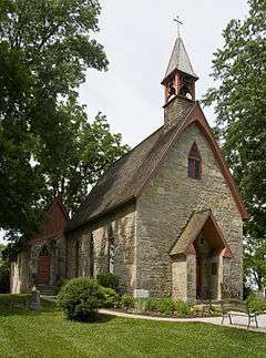
St. Mark's Episcopal Church-Lappans |
|
000000001999-08-05-0000August 5, 1999
(#99000931) |
18313 Lappans Rd.
39°33′03″N 77°44′03″W / 39.550833°N 77.734167°W / 39.550833; -77.734167 (St. Mark's Episcopal Church-Lappans) |
Boonsboro |
|
| 86 |
Tammany |
|
000000001979-09-24-0000September 24, 1979
(#79003262) |
Northeast of Williamsport off U.S. Route 11
39°36′39″N 77°47′44″W / 39.610833°N 77.795556°W / 39.610833; -77.795556 (Tammany) |
Williamsport |
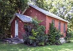
|
| 87 |
Tolson's Chapel |
|
000000002008-10-21-0000October 21, 2008
(#08001012) |
111 E. High St.
39°27′22″N 77°44′47″W / 39.456111°N 77.746389°W / 39.456111; -77.746389 (Tolson's Chapel) |
Sharpsburg |
|
| 88 |
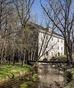
Trovinger Mill |
Upload image |
000000001975-04-21-0000April 21, 1975
(#75000925) |
3 miles (4.8 km) east of Hagerstown on Trovinger Mill Rd. and Antietam Creek
39°39′09″N 77°39′56″W / 39.6525°N 77.665556°W / 39.6525; -77.665556 (Trovinger Mill) |
Hagerstown |
|
| 89 |
Valentia |
|
000000001974-06-27-0000June 27, 1974
(#74000975) |
South of Hagerstown on Poffenberger Rd. off Maryland Route 65
39°35′42″N 77°42′41″W / 39.595°N 77.711389°W / 39.595; -77.711389 (Valentia) |
Hagerstown |
|
| 90 |
Washington County Courthouse |
|
000000001974-12-24-0000December 24, 1974
(#74000976) |
W. Washington St. and Summit Ave.
39°38′34″N 77°43′22″W / 39.642778°N 77.722778°W / 39.642778; -77.722778 (Washington County Courthouse) |
Hagerstown |
|
| 91 |
Washington Monument |
|
000000001972-11-03-0000November 3, 1972
(#72000588) |
Washington Monument State Park
39°29′59″N 77°37′28″W / 39.499722°N 77.624444°W / 39.499722; -77.624444 (Washington Monument) |
Boonsboro |
|
| 92 |
Western Maryland Railroad Right-of-Way, Milepost 126 to Milepost 160 |
Upload image |
000000001981-07-23-0000July 23, 1981
(#81000078) |
Milepost 126 to Milepost 160
39°33′53″N 78°32′08″W / 39.564722°N 78.535556°W / 39.564722; -78.535556 (Western Maryland Railroad Right-of-Way, Milepost 126 to Milepost 160) |
Woodmont |
|
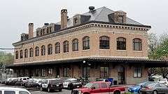
| 93 |
Western Maryland Railway Station |
|
000000001976-04-22-0000April 22, 1976
(#76001019) |
Burhans Boulevard
39°38′44″N 77°43′34″W / 39.645556°N 77.726111°W / 39.645556; -77.726111 (Western Maryland Railway Station) |
Hagerstown |
|
| 94 |
Western Maryland Railway Steam Locomotive No. 202 |
|
000000001984-06-07-0000June 7, 1984
(#84001884) |
City Park
39°38′06″N 77°44′06″W / 39.635°N 77.735°W / 39.635; -77.735 (Western Maryland Railway Steam Locomotive No. 202) |
Hagerstown |
|
| 95 |
Williamsport Historic District |
|
000000002001-10-26-0000October 26, 2001
(#01001184) |
Roughly bounded by the Chesapeake and Ohio Canal, Conococheague Creek, Springfield Ln., and W. Frederick St.
39°35′58″N 77°49′15″W / 39.599444°N 77.820833°W / 39.599444; -77.820833 (Williamsport Historic District) |
Williamsport |
|
| 96 |
The Willows |
Upload image |
000000001973-02-23-0000February 23, 1973
(#73000940) |
Southwest of Cavetown on Maryland Route 66
39°37′34″N 77°36′12″W / 39.626111°N 77.60342°W / 39.626111; -77.60342 (The Willows) |
Cavetown |
|
| 97 |
Wilson School |
|
000000001998-10-30-0000October 30, 1998
(#98001293) |
Rufus Wilson Rd.
39°39′23″N 77°51′11″W / 39.656389°N 77.853056°W / 39.656389; -77.853056 (Wilson School) |
Clear Spring |
|
| 98 |
Wilson's Bridge |
|
000000001982-03-15-0000March 15, 1982
(#82002822) |
U.S. Route 40
39°39′27″N 77°50′53″W / 39.6575°N 77.848056°W / 39.6575; -77.848056 (Wilson's Bridge) |
Hagerstown |
|
| 99 |
Rufus Wilson Complex |
|
000000001996-12-06-0000December 6, 1996
(#96001416) |
14293 Rufus Wilson Rd.
39°39′22″N 77°51′06″W / 39.656111°N 77.851667°W / 39.656111; -77.851667 (Rufus Wilson Complex) |
Clear Spring |
|
| 100 |
Wilson-Miller Farm |
Upload image |
000000001980-05-23-0000May 23, 1980
(#80001841) |
Southeast of Sharpsburg
39°26′24″N 77°45′57″W / 39.44°N 77.765833°W / 39.44; -77.765833 (Wilson-Miller Farm) |
Sharpsburg |
|
| 101 |
Woburn Manor |
Upload image |
000000002000-09-13-0000September 13, 2000
(#00001052) |
7661 Dam #4 Rd.
39°31′24″N 77°48′45″W / 39.523333°N 77.8125°W / 39.523333; -77.8125 (Woburn Manor) |
Sharpsburg |
|
.jpg)


.jpg)