| [3] |
Name on the Register[4] |
Image |
Date listed[5] |
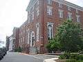
Location |
City or town |
Description |
|---|
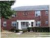
| 1 |
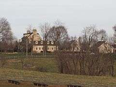
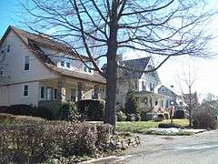
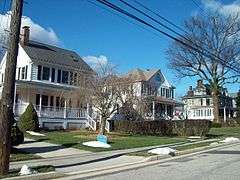
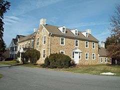
Anneslie Historic District |
Upload image |
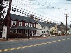
000000002012-03-12-0000March 12, 2012
(#12000097) |
Roughly bounded by York, Maplewood, and Windwood Rds., and Regester Ave.
39°22′33″N 76°36′16″W / 39.375959°N 76.604387°W / 39.375959; -76.604387 (Anneslie Historic District) |
Towson |
|
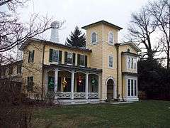
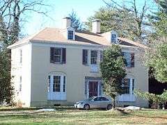
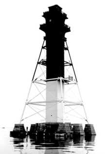
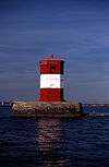
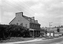
| 2 |
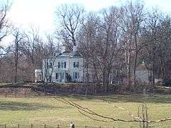
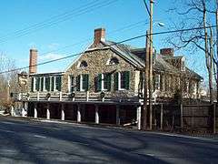
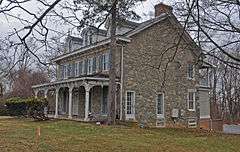
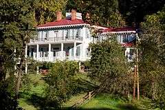
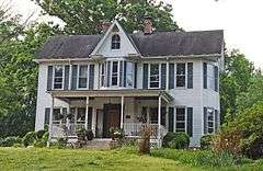
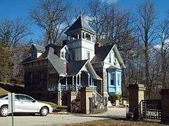
Auburn House |
|
000000001975-03-17-0000March 17, 1975
(#75000869) |
Osler Dr. between Towsontown Boulevard and Stevenson Lane
39°23′10″N 76°36′49″W / 39.386111°N 76.613611°W / 39.386111; -76.613611 (Auburn House) |
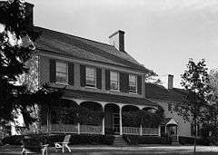
Towson |
|
| 3 |
Ballestone Mansion |
Upload image |
000000001975-06-18-0000June 18, 1975
(#75000866) |
East of Essex on Back River Neck Rd. in Rocky Point Park
39°15′08″N 76°25′03″W / 39.252222°N 76.4175°W / 39.252222; -76.4175 (Ballestone Mansion) |
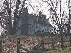
Essex |
|
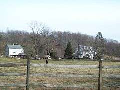
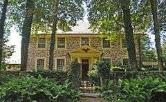
| 4 |
Baltimore County Courthouse |
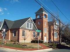
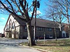
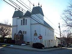
|
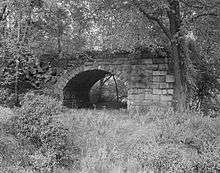
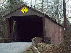
000000001972-10-27-0000October 27, 1972
(#72000569) |
Washington Ave. between Pennsylvania and Chesapeake Aves.
39°23′59″N 76°36′24″W / 39.399722°N 76.606667°W / 39.399722; -76.606667 (Baltimore County Courthouse) |
Towson |
|
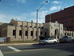
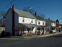
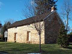
| 5 |
Baltimore County Jail |
|
000000002009-08-26-0000August 26, 2009
(#09000644) |
222 Courthouse Court
39°23′52″N 76°36′29″W / 39.397778°N 76.607917°W / 39.397778; -76.607917 (Baltimore County Jail) |
Towson |
|
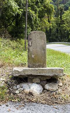
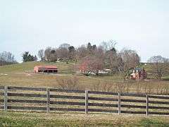
| 6 |
Baltimore County School No. 7 |
|
000000002000-08-31-0000August 31, 2000
(#00001007) |
200 Ashland Rd.
39°29′43″N 76°38′32″W / 39.495278°N 76.642222°W / 39.495278; -76.642222 (Baltimore County School No. 7) |
Cockeysville |
|
| 7 |
Bare Hills Historic District |
|
000000002011-11-22-0000November 22, 2011
(#11000852) |
Falls Rd. between Light Rail and north of Coppermine Terrace
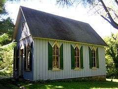
39°23′14″N 76°39′34″W / 39.387264°N 76.659342°W / 39.387264; -76.659342 (Bare Hills Historic District) |
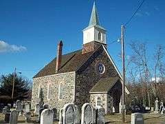
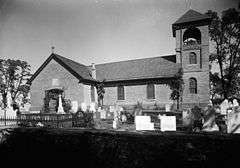
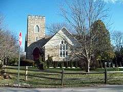
Towson |
|
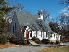
| 8 |
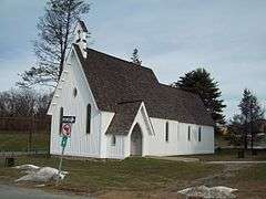
Bare Hills House |
|
000000001980-08-06-0000August 6, 1980
(#80001793) |
North of Baltimore at 6222 Falls Rd.
39°22′55″N 76°39′19″W / 39.38203°N 76.65526°W / 39.38203; -76.65526 (Bare Hills House) |
Towson |
|
| 9 |
Brooklandville House |
|
000000001977-11-23-0000November 23, 1977
(#77000682) |
South of Brooklandville at Falls and Hillside Rds.
39°24′40″N 76°40′03″W / 39.411111°N 76.6675°W / 39.411111; -76.6675 (Brooklandville House) |
Brooklandville |
|
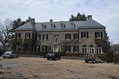
| 10 |
Brooklandwood |
|
000000001972-02-11-0000February 11, 1972
(#72000567) |
Falls Rd.
39°25′50″N 76°40′36″W / 39.430556°N 76.676667°W / 39.430556; -76.676667 (Brooklandwood) |
Brooklandville |
|
| 11 |
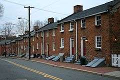
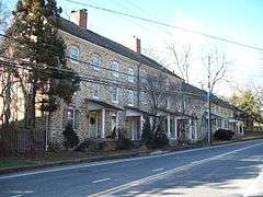
Old Catonsville Historic District |
|
000000002002-12-27-0000December 27, 2002
(#02001573) |
Between Edmondson, Frederick, Melvin, and Smithwood Aves.
39°16′20″N 76°44′40″W / 39.272222°N 76.744444°W / 39.272222; -76.744444 (Old Catonsville Historic District) |
Catonsville |
|
| 12 |
Caves Valley Historic District |
|
000000001988-10-20-0000October 20, 1988
(#88001859) |
Caves and Garrison Forest Rds., and Park Heights Ave.
39°26′30″N 76°44′53″W / 39.441667°N 76.748056°W / 39.441667; -76.748056 (Caves Valley Historic District) |
Owings Mills |
|
| 13 |
Central Catonsville and Summit Park Historic District |
|
000000002006-12-27-0000December 27, 2006
(#06001186) |
Between Frederick Rd., S. Rolling Rd., and Mellor Ave.
39°16′00″N 76°44′15″W / 39.266667°N 76.7375°W / 39.266667; -76.7375 (Central Catonsville and Summit Park Historic District) |
Catonsville |
|
| 14 |
Choate House |
|
000000001989-07-20-0000July 20, 1989
(#89000807) |
9600 Liberty
39°22′35″N 76°48′52″W / 39.376389°N 76.814444°W / 39.376389; -76.814444 (Choate House) |
Randallstown |
|
| 15 |
The Cloisters |
|
000000001979-08-07-0000August 7, 1979
(#79001115) |
West of Lutherville at 10440 Falls Rd.
39°24′39″N 76°40′17″W / 39.410833°N 76.671389°W / 39.410833; -76.671389 (The Cloisters) |
Lutherville |
|
| 16 |
Corbett Historic District |
Upload image |
000000001985-09-12-0000September 12, 1985
(#85002245) |
1615-1827 Corbett Rd. and 16200-16225 Corbett Village Ln.
39°34′09″N 76°37′03″W / 39.569167°N 76.6175°W / 39.569167; -76.6175 (Corbett Historic District) |
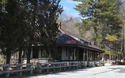
Monkton |
|
| 17 |
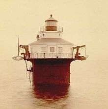
Craighill Channel Lower Range Front Light Station |
|
000000002002-12-02-0000December 2, 2002
(#02001420) |
3.5 miles southeast of Fort Howard
39°11′19″N 76°23′39″W / 39.188611°N 76.394167°W / 39.188611; -76.394167 (Craighill Channel Lower Range Front Light Station) |
Fort Howard |
|
| 18 |
Craighill Channel Lower Range Rear Light Station |
|
000000002002-12-02-0000December 2, 2002
(#02001418) |
Edgemere area
39°13′45″N 76°23′40″W / 39.229186°N 76.394408°W / 39.229186; -76.394408 (Craighill Channel Lower Range Rear Light Station) |
Edgemere |
|
| 19 |
Cut-off Channel Range Front Light Station |
|
000000002002-12-02-0000December 2, 2002
(#02001415) |
Southwest of Fort Howard
39°11′49″N 76°26′55″W / 39.196944°N 76.448611°W / 39.196944; -76.448611 (Cut-off Channel Range Front Light Station) |
Fort Howard |
|
| 20 |
Cut-off Channel Range Rear Light Station |
|
000000002002-12-02-0000December 2, 2002
(#02001423) |
Sparrows Point
39°12′58″N 76°27′47″W / 39.216111°N 76.463056°W / 39.216111; -76.463056 (Cut-off Channel Range Rear Light Station) |
Edgemore |
|
| 21 |
Dumbarton Historic District |
|
000000002009-12-30-0000December 30, 2009
(#09001172) |
Roughly bounded by Park Heights Ave., Slade Ave., Seven Mile La., and Old Court Rd.
39°22′37″N 76°42′37″W / 39.376931°N 76.710258°W / 39.376931; -76.710258 (Dumbarton Historic District) |
Pikesville |
|
| 22 |
Dundalk Historic District |
|
000000001983-12-08-0000December 8, 1983
(#83003630) |
Roughly bounded by Liberty Parkway, Dunman, Willow Spring and Sunship Rds., and Chesapeake and Patapsco Aves.
39°15′35″N 76°31′26″W / 39.259722°N 76.523889°W / 39.259722; -76.523889 (Dundalk Historic District) |
Dundalk |
|
| 23 |
Dundalk-Liberty-Cornwall Gardens |
|
000000002011-09-23-0000September 23, 2011
(#11000700) |
7003 Dunmanway
39°15′27″N 76°31′06″W / 39.2575°N 76.518333°W / 39.2575; -76.518333 (Dundalk-Liberty-Cornwall Gardens) |
Dundalk |
|
| 24 |
Eagle's Nest |
|
000000001974-07-25-0000July 25, 1974
(#74000942) |
Jarrettsville Pike
39°28′15″N 76°34′32″W / 39.470833°N 76.575556°W / 39.470833; -76.575556 (Eagle's Nest) |
Phoenix |
|
| 25 |
Ellicott's Mills Historic District |
|
000000001976-11-19-0000November 19, 1976
(#76000980) |
Both sides of Maryland Route 144, south of the Patapsco River Bridge
39°16′05″N 76°47′32″W / 39.268056°N 76.792222°W / 39.268056; -76.792222 (Ellicott's Mills Historic District) |
Oella |
|
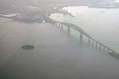
| 26 |
Fort Carroll |
|
000000002015-04-14-0000April 14, 2015
(#14000955) |
Soller's Flats, in the Patapsco River
39°12′53″N 76°31′09″W / 39.2146°N 76.5192°W / 39.2146; -76.5192 (Fort Carroll) |
Curtis Bay |
|
| 27 |
Fort Garrison |
|
000000001971-01-25-0000January 25, 1971
(#71000368) |
South of Stevenson at Garrison Farms Ct.
39°23′55″N 76°42′29″W / 39.398611°N 76.708056°W / 39.398611; -76.708056 (Fort Garrison) |
Stevenson |
|
| 28 |
Glencoe |
|
000000001983-05-09-0000May 9, 1983
(#83002942) |
1314 Glencoe Rd.
39°33′04″N 76°38′06″W / 39.551111°N 76.635°W / 39.551111; -76.635 (Glencoe) |
Glencoe |
|
| 29 |
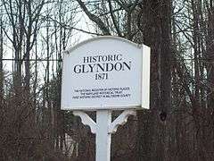
Glyndon Historic District |
|
000000001973-09-20-0000September 20, 1973
(#73000902) |
Town of Glyndon and its environs along Maryland Route 128
39°28′30″N 76°48′38″W / 39.475°N 76.810556°W / 39.475; -76.810556 (Glyndon Historic District) |
Glyndon |
|
| 30 |
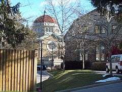
Goucher College |
|
000000002007-08-28-0000August 28, 2007
(#07000885) |
1021 Dulaney Valley Rd.
39°24′39″N 76°36′01″W / 39.41085°N 76.600353°W / 39.41085; -76.600353 (Goucher College) |
Towson |
|
| 31 |
Granite Historic District |
|
000000001994-09-22-0000September 22, 1994
(#94001091) |
Roughly the area surrounding Old Court Rd. and St. Paul Ave.
39°20′36″N 76°50′51″W / 39.343333°N 76.8475°W / 39.343333; -76.8475 (Granite Historic District) |
Granite |
|
| 32 |
Green Spring Valley Historic District |
|
000000001980-10-03-0000October 3, 1980
(#80001797) |
Maryland Routes 25 and 140
39°24′55″N 76°42′46″W / 39.415278°N 76.712778°W / 39.415278; -76.712778 (Green Spring Valley Historic District) |
Lutherville and Owings Mills |
|
| 33 |
Half-Way House |
|
000000001980-09-08-0000September 8, 1980
(#89000809) |
1.3 miles south of Parkton at 18200 York Rd.; also York Rd. and Weisburg Rd
39°37′24″N 76°39′31″W / 39.623333°N 76.658611°W / 39.623333; -76.658611 (Half-Way House) |
Parkton |
Second address represents a boundary increase, added on 000000001989-07-12-0000July 12, 1989
|
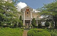
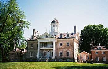
| 34 |
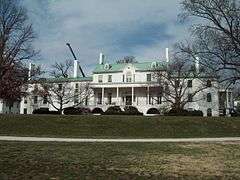
Hampton National Historic Site |
|
000000001966-10-15-0000October 15, 1966
(#66000389) |
535 Hampton Lane
39°25′02″N 76°35′17″W / 39.417222°N 76.588056°W / 39.417222; -76.588056 (Hampton National Historic Site) |
Towson |
|
| 35 |
Hill House |
Upload image |
000000001986-03-06-0000March 6, 1986
(#86000415) |
19301 York Rd.
39°39′12″N 76°39′10″W / 39.653333°N 76.652778°W / 39.653333; -76.652778 (Hill House) |
Parkton |
|
| 36 |
Hilton |
|
000000001980-10-31-0000October 31, 1980
(#80001794) |
800 S. Rolling Rd.
39°15′09″N 76°44′01″W / 39.2525°N 76.733611°W / 39.2525; -76.733611 (Hilton) |
Catonsville |
|
| 37 |
Hull Memorial Christian Church |
|
000000001977-09-15-0000September 15, 1977
(#77000684) |
101 Clyde Ave.
39°14′41″N 76°39′48″W / 39.244722°N 76.663333°W / 39.244722; -76.663333 (Hull Memorial Christian Church) |
Lansdowne |
|
| 38 |
Jericho Covered Bridge |
|
000000001978-09-13-0000September 13, 1978
(#78001444) |
East of Kingsville on Franklinville Rd.
39°27′34″N 76°23′16″W / 39.459444°N 76.387778°W / 39.459444; -76.387778 (Jericho Covered Bridge) |
Kingsville |
|
| 39 |
Jericho Farm |
|
000000001984-09-07-0000September 7, 1984
(#84001352) |
12230 Jericho Rd.
39°27′23″N 76°23′17″W / 39.456389°N 76.388056°W / 39.456389; -76.388056 (Jericho Farm) |
Kingsville |
|
| 40 |
James Lawrence Kernan Hospital |
|
000000001979-09-24-0000September 24, 1979
(#79003275) |
Windsor Mill Rd. and Forest Park Ave.
39°18′48″N 76°42′34″W / 39.313333°N 76.709444°W / 39.313333; -76.709444 (James Lawrence Kernan Hospital) |
Wetheredsville |
|
| 41 |
Long Green Valley Historic District |
Upload image |
000000001982-12-30-0000December 30, 1982
(#82001589) |
Glen Arm, Baldwin Mill, Manor, and Hartford Rds. areas
39°28′35″N 76°29′23″W / 39.476389°N 76.489722°W / 39.476389; -76.489722 (Long Green Valley Historic District) |
Baldwin, Glen Arm, Hydes |
|
| 42 |
Long Island Farm |
Upload image |
000000002010-08-30-0000August 30, 2010
(#10000586) |
220 Cromwell Bridge Rd.
39°25′05″N 76°32′33″W / 39.418056°N 76.5425°W / 39.418056; -76.5425 (Long Island Farm) |
Parkville |
|
| 43 |
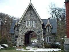
Lorraine Park Cemetery Gate Lodge |
|
000000001985-07-25-0000July 25, 1985
(#85001613) |
5608 Dogwood Rd.
39°18′47″N 76°43′05″W / 39.313056°N 76.718056°W / 39.313056; -76.718056 (Lorraine Park Cemetery Gate Lodge) |
Woodlawn |
|
| 44 |
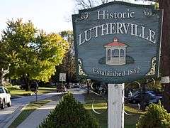
Lutherville Historic District |
|
000000001972-11-09-0000November 9, 1972
(#72000568) |
Roughly bounded by Interstate 695, York and Ridgely Rds., and Lutherville Dr.
39°25′19″N 76°38′41″W / 39.421944°N 76.644722°W / 39.421944; -76.644722 (Lutherville Historic District) |
Lutherville |
|
| 45 |
The Meadows |
|
000000001988-03-23-0000March 23, 1988
(#88000203) |
302 Meadows Ln.
39°24′05″N 76°47′52″W / 39.401389°N 76.797778°W / 39.401389; -76.797778 (The Meadows) |
Owings Mills |
|
| 46 |
Mettam Memorial Baptist Church |
|
000000001975-04-24-0000April 24, 1975
(#75000867) |
Old Court Rd. between Sudbrook and Reisterstown Rds.
39°22′41″N 76°43′10″W / 39.378056°N 76.719444°W / 39.378056; -76.719444 (Mettam Memorial Baptist Church) |
Pikesville |
|
| 47 |
Montrose Mansion and Chapel |
Upload image |
000000001990-03-19-0000March 19, 1990
(#90000354) |
13700 Hanover Rd.
39°29′52″N 76°51′09″W / 39.497778°N 76.8525°W / 39.497778; -76.8525 (Montrose Mansion and Chapel) |
Reisterstown |
|
| 48 |
Mount de Sales Academy |
|
000000001986-05-30-0000May 30, 1986
(#86001187) |
700 Academy Rd.
39°17′06″N 76°43′17″W / 39.285°N 76.721389°W / 39.285; -76.721389 (Mount de Sales Academy) |
Catonsville |
|
| 49 |
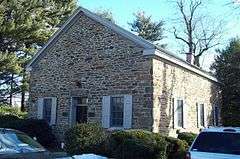
Mt. Gilboa Chapel |
|
000000001976-10-21-0000October 21, 1976
(#76000978) |
Oella and Westchester Aves.
39°16′27″N 76°46′45″W / 39.274283°N 76.779033°W / 39.274283; -76.779033 (Mt. Gilboa Chapel) |
Oella |
|
| 50 |
My Lady's Manor |
|
000000001978-04-15-0000April 15, 1978
(#78001445) |
Maryland Route 138
39°35′15″N 76°34′16″W / 39.5875°N 76.571111°W / 39.5875; -76.571111 (My Lady's Manor) |
Monkton |
|
| 51 |
Oella Historic District |
|
000000001976-11-07-0000November 7, 1976
(#76000979) |
Oella Ave., Glen Rd., Hollow Rd.
39°16′49″N 76°47′09″W / 39.280278°N 76.785833°W / 39.280278; -76.785833 (Oella Historic District) |
Oella |
|
| 52 |
Old Catonsville High School |
|
000000001987-09-10-0000September 10, 1987
(#87001568) |
20 Winters Ln.
39°16′22″N 76°44′10″W / 39.272778°N 76.736111°W / 39.272778; -76.736111 (Old Catonsville High School) |
Catonsville |
|
| 53 |
Old National Pike Milestones |
|
000000001975-11-27-0000November 27, 1975
(#75002107) |
U.S. Route 40, U.S. Route 40 Alternate, and U.S. Route 40 Scenic, and Maryland Routes 144 and 165
39°16′23″N 76°43′37″W / 39.273117°N 76.727011°W / 39.273117; -76.727011 (Old National Pike Milestones) |
Catonsville |
|
| 54 |
Old Salem Church and Cemetery |
|
000000001977-12-13-0000December 13, 1977
(#77000683) |
Ingleside Ave. and Calverton St.
39°17′05″N 76°43′53″W / 39.284722°N 76.731389°W / 39.284722; -76.731389 (Old Salem Church and Cemetery) |
Catonsville |
|
| 55 |
Owings Upper Mill |
|
000000001978-09-13-0000September 13, 1978
(#78001446) |
Reisterstown Rd. and Groff Ln.
39°25′19″N 76°46′59″W / 39.421936°N 76.78314°W / 39.421936; -76.78314 (Owings Upper Mill) |
Owings Mills |
|
| 56 |
Parkton Hotel |
Upload image |
000000001983-12-08-0000December 8, 1983
(#83003634) |
18848 York Rd. (MD 45)
39°38′30″N 76°39′34″W / 39.641667°N 76.659444°W / 39.641667; -76.659444 (Parkton Hotel) |
Parkton |
|
| 57 |
Patterson Viaduct Ruins |
|
000000001976-06-03-0000June 3, 1976
(#76002221) |
South of Catonsville at the Patapsco River
39°15′00″N 76°45′51″W / 39.25°N 76.764167°W / 39.25; -76.764167 (Patterson Viaduct Ruins) |
Catonsville |
|
| 58 |
Perry Hall |
|
000000001980-04-23-0000April 23, 1980
(#80001796) |
North of Perry Hall on Perry Hall Rd.
39°25′43″N 76°27′33″W / 39.428611°N 76.459167°W / 39.428611; -76.459167 (Perry Hall) |
Perry Hall |
|
| 59 |
Pikesville Armory |
|
000000001985-09-25-0000September 25, 1985
(#85002674) |
610 Reisterstown Rd.
39°22′08″N 76°43′18″W / 39.368889°N 76.721667°W / 39.368889; -76.721667 (Pikesville Armory) |
Pikesville |
|
| 60 |
Plinlimmon Farm |
|
000000001983-05-19-0000May 19, 1983
(#83002943) |
9401 Lyons Mill Rd.
39°23′35″N 76°47′59″W / 39.393056°N 76.799722°W / 39.393056; -76.799722 (Plinlimmon Farm) |
Owings Mills |
|
| 61 |
Prospect Hill |
|
000000001973-07-26-0000July 26, 1973
(#73000903) |
Northeast of Long Green on Kane's Rd.
39°28′48″N 76°30′47″W / 39.48°N 76.513056°W / 39.48; -76.513056 (Prospect Hill) |
Long Green |
|
| 62 |
Ravenshurst |
Upload image |
000000001978-08-14-0000August 14, 1978
(#78001443) |
12915 Dulaney Valley Rd.
39°28′48″N 76°31′50″W / 39.48°N 76.530556°W / 39.48; -76.530556 (Ravenshurst) |
Glen Arm |
|
| 63 |
Reisterstown Historic District |
|
000000001979-11-15-0000November 15, 1979
(#79001118) |
Maryland Routes 30 and 140
39°27′49″N 76°49′32″W / 39.463611°N 76.825556°W / 39.463611; -76.825556 (Reisterstown Historic District) |
Reisterstown |
|
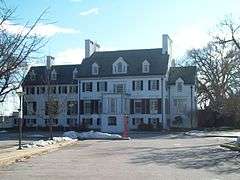
| 64 |
Rockland |
|
000000001983-02-02-0000February 2, 1983
(#83002944) |
10214 Falls Rd.
39°24′11″N 76°40′15″W / 39.403056°N 76.670833°W / 39.403056; -76.670833 (Rockland) |
Brooklandville |
|
| 65 |
Rockland Historic District |
|
000000001973-04-11-0000April 11, 1973
(#73000899) |
Both sides of Falls Rd. (Maryland Route 25) at its junction with Old Court Rd. (Maryland Route 133)
39°24′03″N 76°40′06″W / 39.400833°N 76.668333°W / 39.400833; -76.668333 (Rockland Historic District) |
Brooklandville |
|
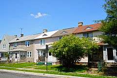
| 66 |
Rodgers Forge Historic District |
Upload image |
000000002009-09-24-0000September 24, 2009
(#09000783) |
Roughly bounded by Stanmore Rd., Stevenson La., York Rd., Regester Ave., and Bellona Ave.
39°22′52″N 76°37′02″W / 39.380975°N 76.617128°W / 39.380975; -76.617128 (Rodgers Forge Historic District) |
Towson |
|
| 67 |
Sheppard and Enoch Pratt Hospital and Gatehouse |
|
000000001971-11-11-0000November 11, 1971
(#71000369) |
Charles St.
39°23′28″N 76°37′09″W / 39.391111°N 76.619167°W / 39.391111; -76.619167 (Sheppard and Enoch Pratt Hospital and Gatehouse) |
Towson |
|
| 68 |
St. Charles College Historic District |
|
000000001983-09-30-0000September 30, 1983
(#83002945) |
711 Maiden Choice Lane
39°16′07″N 76°42′46″W / 39.268611°N 76.712778°W / 39.268611; -76.712778 (St. Charles College Historic District) |
Catonsville |
|
| 69 |
St. James Church |
|
000000001974-09-12-0000September 12, 1974
(#74000941) |
Southeast of Monkton off Manor Rd.
39°33′41″N 76°34′11″W / 39.561389°N 76.569722°W / 39.561389; -76.569722 (St. James Church) |
Monkton |
|
| 70 |
St. John's Church |
|
000000001982-03-15-0000March 15, 1982
(#82002807) |
7538 Bellona Ave.
39°23′41″N 76°38′39″W / 39.394667°N 76.644028°W / 39.394667; -76.644028 (St. John's Church) |
Ruxton |
|
| 71 |
St. Mary's Episcopal Church |
|
000000001985-03-14-0000March 14, 1985
(#85000583) |
5610 Dogwood Rd.
39°18′47″N 76°43′16″W / 39.313056°N 76.721111°W / 39.313056; -76.721111 (St. Mary's Episcopal Church) |
Woodlawn |
|
| 72 |
St. Michael's Church |
|
000000001979-10-22-0000October 22, 1979
(#79003273) |
Academy Lane and Reisterstown Rd.
39°27′04″N 76°49′08″W / 39.451111°N 76.818889°W / 39.451111; -76.818889 (St. Michael's Church) |
Reisterstown |
|
| 73 |
St. Thomas Church |
|
000000001979-05-24-0000May 24, 1979
(#79001117) |
St. Thomas Lane and Garrison Forest Rd.
39°25′19″N 76°45′43″W / 39.421944°N 76.761944°W / 39.421944; -76.761944 (St. Thomas Church) |
Owings Mills |
|
| 74 |
Stone Hall |
|
000000001973-07-26-0000July 26, 1973
(#73000900) |
North of Cockeysville off Maryland Route 25 on Cuba Rd.
39°30′34″N 76°41′58″W / 39.509444°N 76.699444°W / 39.509444; -76.699444 (Stone Hall) |
Cockeysville |
|
| 75 |
Stoneleigh Historic District |
|
000000002003-11-08-0000November 8, 2003
(#03001113) |
Roughly bounded by Regester Ave., York Rd., Hatherleigh Rd., and Kenleigh Rd.
39°22′46″N 76°36′16″W / 39.379444°N 76.604444°W / 39.379444; -76.604444 (Stoneleigh Historic District) |
Towson |
|
| 76 |
Sudbrook Park |
|
000000001973-06-19-0000June 19, 1973
(#73000904) |
South of Pikesville off U.S. Route 40 on Greenwood Rd.
39°21′58″N 76°43′49″W / 39.366111°N 76.730278°W / 39.366111; -76.730278 (Sudbrook Park) |
Pikesville |
|
| 77 |
Summit |
|
000000001979-07-24-0000July 24, 1979
(#79001114) |
10 Stanley Dr.
39°16′06″N 76°44′35″W / 39.268333°N 76.743056°W / 39.268333; -76.743056 (Summit) |
Catonsville |
|
| 78 |
The Wilderness |
|
000000001985-09-12-0000September 12, 1985
(#85002173) |
2 Thistle Rd.
39°15′27″N 76°46′03″W / 39.2575°N 76.7675°W / 39.2575; -76.7675 (The Wilderness) |
Catonsville |
|
| 79 |
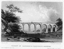
Thomas Viaduct, Baltimore & Ohio Railroad |
|
000000001966-10-15-0000October 15, 1966
(#66000388) |
Over the Patapsco River between Relay and Elkridge
39°13′19″N 76°42′49″W / 39.221944°N 76.713611°W / 39.221944; -76.713611 (Thomas Viaduct, Baltimore & Ohio Railroad) |
Relay |
|
| 80 |
Todd Farmhouse |
Upload image |
000000001973-10-18-0000October 18, 1973
(#73000901) |
9000 Old North Point Rd. (Maryland Route 20)
39°12′49″N 76°26′18″W / 39.213611°N 76.438333°W / 39.213611; -76.438333 (Todd Farmhouse) |
Fort Howard |
|
| 81 |
Towson Academy |
|
000000001985-09-25-0000September 25, 1985
(#85002675) |
Washington St. and Chesapeake Ave.
39°23′57″N 76°36′20″W / 39.399167°N 76.605556°W / 39.399167; -76.605556 (Towson Academy) |
Towson |
|
| 82 |
Tyrconnell |
|
000000001985-03-14-0000March 14, 1985
(#85000582) |
120 Woodbrook Lane
39°22′50″N 76°38′08″W / 39.380556°N 76.635556°W / 39.380556; -76.635556 (Tyrconnell) |
Towson |
|
| 83 |
Villa Anneslie |
|
000000001977-12-13-0000December 13, 1977
(#77000685) |
529 Dunkirk Rd.
39°22′34″N 76°36′20″W / 39.376111°N 76.605556°W / 39.376111; -76.605556 (Villa Anneslie) |
Towson |
|
| 84 |
Wester Ogle |
|
000000001985-01-11-0000January 11, 1985
(#85000058) |
8948-8950 Reisterstown Rd.
39°23′31″N 76°45′01″W / 39.391944°N 76.750278°W / 39.391944; -76.750278 (Wester Ogle) |
Pikesville |
|
| 85 |
Western Run-Belfast Road Historic District |
|
000000001979-01-23-0000January 23, 1979
(#79001116) |
Northwest of Lutherville
39°31′45″N 76°41′39″W / 39.529167°N 76.694167°W / 39.529167; -76.694167 (Western Run-Belfast Road Historic District) |
Lutherville |
|
| 86 |
Winters Lane Historic District |
|
000000002007-12-21-0000December 21, 2007
(#07001285) |
Winters Ln. between Frederick Rd. and Baltimore National Pike.
39°16′45″N 76°44′31″W / 39.279072°N 76.741883°W / 39.279072; -76.741883 (Winters Lane Historic District) |
Catonsville |
|
| 87 |
Worthington Valley Historic District |
|
000000001976-12-12-0000December 12, 1976
(#76000977) |
Bounded by Falls and Shawan Rds., Tufton and Worthington Aves., and the Baltimore Gas and Electric Right-of-Way
39°29′59″N 76°45′19″W / 39.499722°N 76.755278°W / 39.499722; -76.755278 (Worthington Valley Historic District) |
Glyndon |
|
.jpg)
_Church_2012.jpg)