Sharon, California
| Sharon | |
|---|---|
| Unincorporated community | |
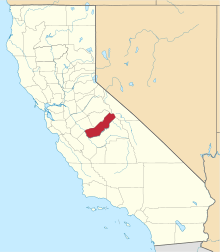
 Sharon  Sharon Location in California | |
| Coordinates: 37°05′53″N 120°07′48″W / 37.09806°N 120.13000°WCoordinates: 37°05′53″N 120°07′48″W / 37.09806°N 120.13000°W | |
| Country | United States |
| State | California |
| County | Madera County |
| Elevation[1] | 295 ft (90 m) |
Sharon is an unincorporated community in Madera County, California.[1] It is located on the Atchison, Topeka and Santa Fe Railroad 4 miles (6.4 km) east-northeast of Fairmead,[2] at an elevation of 295 feet (90 m).[1]
A post office operated at Sharon from 1898 to 1927.[2] San Francisco financier William Sharon was a promoter of the settlement, that later bore his name.[2]
References
This article is issued from Wikipedia - version of the 7/5/2016. The text is available under the Creative Commons Attribution/Share Alike but additional terms may apply for the media files.