Severobaykalsk
| Severobaikalsk (English) Северобайкальск (Russian) Хойто-Байгал (Buryat) | |
|---|---|
| - Town - | |
 Severobaikalsk railway station | |
.svg.png) Severobaikalsk | |
|
| |
| Administrative status (as of May 2010) | |
| Country | Russia |
| Federal subject | Republic of Buryatia |
| Administratively subordinated to | town of republic significance of Severobaikalsk[1] |
| Administrative center of | town of republic significance of Severobaikalsk[1] |
| Municipal status (as of October 2011) | |
| Urban okrug | Severobaikalsk Urban Okrug[2] |
| Administrative center of | Severobaikalsk Urban Okrug[2] |
| Mayor | Vladimir Bodrov |
| Statistics | |
| Population (2010 Census) | 24,929 inhabitants[3] |
| Time zone | IRKT (UTC+08:00)[4] |
| Founded | 1974 |
| Town status since | 1980[5] |
| Postal code(s)[6] | 81420 |
| Dialing code(s) | +7 30130 |
| Severobaikalsk on Wikimedia Commons | |
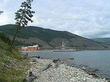
Severobaikalsk (Russian: Северобайка́льск; Buryat: Хойто-Байгал, Khojto-Bajgal) is a town in the Republic of Buryatia, Russia, located on the northern end of Lake Baikal at the mouth of the Tyya River, 440 kilometers (270 mi) northwest of Ulan-Ude and 490 kilometers (300 mi) northeast of Irkutsk. Population: 24,929 (2010 Census);[3] 25,434 (2002 Census);[7] 28,336 (1989 Census).[8]
Geography
Severobaikalsk is located on a plateau at the northern end of Lake Baikal at the mouth of the Tyya River. To the west the town is surrounded by the Baikal Mountains, to the northeast by the Stanovoy Range. Severobaikalsk is geographically isolated, the closest town is Ust-Kut, more than 260 kilometers (160 mi) away. The closest large cities are Ulan-Ude, 440 kilometers (270 mi) to the southeast and Irkutsk, more than 490 kilometers (300 mi) to the southwest.
History
The history of Severobaikalsk is closely related to the history of the Baikal-Amur Mainline (BAM). It was founded in 1974 as a work settlement for workers constructing the BAM, serving as a logistics center and a central starting point for the railway project. To the west the railway line was developed to Bratsk and to the east to Tynda. At this time the only settlement in the area was the village Nizhneangarsk, located at the edge of a swampy plain at the northern tip of the lake. It was decided to develop the new town Severobaikalsk 20 kilometers (12 mi) southwest of Nizhneangarsk on a plateau above the lake, thus allowing further extensions and development in the future.[9] Originally it was planned to increase the population to 140,000 people.[10]
The first volunteers of the Komsomol and workers arrived in 1974 and founded a work camp that would later become the town of Severobaikalsk. The camp was initially named Novogodny (Russian: Новогодний, lit. New Year) and consisted of tents, wooden shacks and railway cars. The camp grew rapidly with the development of the railway, and Severobaikalsk was eventually granted town status in 1980.[5] During this time until official completion of the railway line in 1984 the town had a partnership with Leningrad. Since completion of the Baikal Amur Mainline the town has been in decline, with many projects cancelled during Perestroika.[9]
Population reached a high with an estimated 35,000 inhabitants in the 1980s and subsequently declined. As the town was founded mostly by volunteers of the Komsomol the population is relatively young. Ninety percent of the population is Russian Orthodox and ten percent are Buryats.[9]
Administrative and municipal status
Within the framework of administrative divisions, it is incorporated as the town of republic significance of Severobaikalsk—an administrative unit with the status equal to that of the districts.[1] As a municipal division, the town of republic significance of Severobaikalsk is incorporated as Severobaikalsk Urban Okrug.[2]
Climate
As a Siberian town, Severobaikalsk experiences a subarctic climate, characterized by extreme variation of temperatures between seasons. Temperatures can be very warm in the summer, and brutally cold in the winter. The warmest month of the year in Severobaikalsk is July, when the mean temperature is +16 °C (61 °F). The coldest month of the year is January, when the mean temperature is only −23 °C (−9 °F).
| Climate data for Severobaikalsk | |||||||||||||
|---|---|---|---|---|---|---|---|---|---|---|---|---|---|
| Month | Jan | Feb | Mar | Apr | May | Jun | Jul | Aug | Sep | Oct | Nov | Dec | Year |
| Average high °C (°F) | −17.3 (0.9) |
−14.7 (5.5) |
−4.8 (23.4) |
3.6 (38.5) |
12.0 (53.6) |
19.5 (67.1) |
22.4 (72.3) |
20.9 (69.6) |
13.7 (56.7) |
3.8 (38.8) |
−6.3 (20.7) |
−12.9 (8.8) |
3.33 (37.99) |
| Daily mean °C (°F) | −22.9 (−9.2) |
−21.6 (−6.9) |
−12.9 (8.8) |
−2.9 (26.8) |
5.0 (41) |
11.9 (53.4) |
15.7 (60.3) |
14.7 (58.5) |
7.9 (46.2) |
−1.0 (30.2) |
−11.5 (11.3) |
−18.2 (−0.8) |
−2.98 (26.63) |
| Average low °C (°F) | −28.4 (−19.1) |
−28.5 (−19.3) |
−21.0 (−5.8) |
−9.4 (15.1) |
−1.9 (28.6) |
4.4 (39.9) |
9.1 (48.4) |
8.6 (47.5) |
2.2 (36) |
−5.8 (21.6) |
−16.7 (1.9) |
−23.4 (−10.1) |
−9.23 (15.39) |
| Average precipitation mm (inches) | 16 (0.63) |
12 (0.47) |
10 (0.39) |
17 (0.67) |
28 (1.1) |
37 (1.46) |
65 (2.56) |
63 (2.48) |
42 (1.65) |
23 (0.91) |
22 (0.87) |
19 (0.75) |
354 (13.94) |
| Source: Climate-Data.org [11] | |||||||||||||
Cityscape
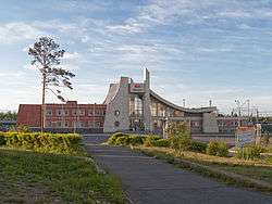
Like most Soviet-planned cities, the town center is dominated by five to six floor high rise buildings made of prefabricated concrete panels. Because the northern region of Lake Baikal is in a seismically active region the standard design of the high rise buildings has been adapted to ensure greater resistance to earthquakes. The suburbs are dominated by shacks that trace back to the early foundation period when Severobaikalsk was a work camp. Some of these shacks are made of old railway cars.
The main street of Severobaikalsk is Leningradsky Avenue, which starts at the railway station and runs through the central area of the town. The railway station is shaped similar to a sail and was designed by architects from Leningrad. In front of the railway station is a monument to volunteers and workers from Leningrad who built the town. North of the railway station, along Leningradsky Avenue is the main square, where the town administration and the Palace of Culture of the railway workers are located. Severobaikalsk also has a church and a museum dedicated to the history of the Baikal Amur Mainline.[5]
Transport
There are no road connections to the outside world. Railroads and airplanes serve as the dominant means of external travel.
By rail, Severobaykalsk is connected by the Baikal-Amur Mainline to Bratsk and Tayshet in the west and Tynda and Komsomolsk-on-Amur and in the east. By air Severobaikalsk is connected with Irkutsk and Ulan-Ude via Nizhneangarsk Airport located 23 kilometers (14 mi) north of the town.
In the summer Voskhod hydrofoils connect Severobaykalsk with Irkutsk via Port Baikal.
References
Notes
- 1 2 3 Resolution #431
- 1 2 3 Law #985-III
- 1 2 Russian Federal State Statistics Service (2011). "Всероссийская перепись населения 2010 года. Том 1" [2010 All-Russian Population Census, vol. 1]. Всероссийская перепись населения 2010 года (2010 All-Russia Population Census) (in Russian). Federal State Statistics Service. Retrieved June 29, 2012.
- ↑ Правительство Российской Федерации. Федеральный закон №107-ФЗ от 3 июня 2011 г. «Об исчислении времени», в ред. Федерального закона №271-ФЗ от 03 июля 2016 г. «О внесении изменений в Федеральный закон "Об исчислении времени"». Вступил в силу по истечении шестидесяти дней после дня официального опубликования (6 августа 2011 г.). Опубликован: "Российская газета", №120, 6 июня 2011 г. (Government of the Russian Federation. Federal Law #107-FZ of June 31, 2011 On Calculating Time, as amended by the Federal Law #271-FZ of July 03, 2016 On Amending Federal Law "On Calculating Time". Effective as of after sixty days following the day of the official publication.).
- 1 2 3 Terentyev, Yuri. "Northern Baikal area - Information about Severobaikalsk City". Archived from the original on September 26, 2006. Retrieved January 4, 2013.
- ↑ Почта России. Информационно-вычислительный центр ОАСУ РПО. (Russian Post). Поиск объектов почтовой связи (Postal Objects Search) (Russian)
- ↑ Russian Federal State Statistics Service (May 21, 2004). "Численность населения России, субъектов Российской Федерации в составе федеральных округов, районов, городских поселений, сельских населённых пунктов – районных центров и сельских населённых пунктов с населением 3 тысячи и более человек" [Population of Russia, Its Federal Districts, Federal Subjects, Districts, Urban Localities, Rural Localities—Administrative Centers, and Rural Localities with Population of Over 3,000] (XLS). Всероссийская перепись населения 2002 года [All-Russia Population Census of 2002] (in Russian). Retrieved August 9, 2014.
- ↑ Demoscope Weekly (1989). "Всесоюзная перепись населения 1989 г. Численность наличного населения союзных и автономных республик, автономных областей и округов, краёв, областей, районов, городских поселений и сёл-райцентров" [All Union Population Census of 1989: Present Population of Union and Autonomous Republics, Autonomous Oblasts and Okrugs, Krais, Oblasts, Districts, Urban Settlements, and Villages Serving as District Administrative Centers]. Всесоюзная перепись населения 1989 года [All-Union Population Census of 1989] (in Russian). Институт демографии Национального исследовательского университета: Высшая школа экономики [Institute of Demography at the National Research University: Higher School of Economics]. Retrieved August 9, 2014.
- 1 2 3 Merkel, Broder (November 2004). "Severobaikal'sk - A new town". Retrieved 2008-03-16.
- ↑ Stewart, John Massy (1991). Lake Baikal: On the Brink?. The World Conservation Union. p. 20. ISBN 2-8317-0037-X.
- ↑ "Severobaikalsk, Russia". Retrieved 23 January 2013.
Sources
- Правительство Республики Бурятия. Постановление №431 от 18 ноября 2009 г. «О реестре административно-территориальных единиц и населённых пунктов Республики Бурятия», в ред. Постановления №573 от 13 ноября 2015 г. «О внесении изменений в Постановление Правительства Республики Бурятия от 18.11.2009 №431 "О реестре административно-территориальных единиц и населённых пунктов Республики Бурятия"». Вступил в силу 18 ноября 2009 г. Опубликован: "Бурятия", №216, Официальный вестник №120, 21 ноября 2009 г. (Government of the Republic of Buryatia. Resolution #431 of November 18, 2009 On the Registry of the Administrative-Territorial Units and the Inhabited Localities of the Republic of Buryatia, as amended by the Resolution #573 of November 13, 2015 On Amending Resolution #431 of November 18, 2009 of the Government of the Republic of Buryatia "On the Registry of the Administrative-Territorial Units and the Inhabited Localities of the Republic of Buryatia". Effective as of November 18, 2009.).
- Народный Хурал Республики Бурятия. Закон №985-III от 31 декабря 2004 г. «Об установлении границ, образовании и наделении статусом муниципальных образований в Республике Бурятия», в ред. Закона №1411-V от 14 октября 2015 г. «О внесении изменений в Закон Республики Бурятия "Об установлении границ, образовании и наделении статусом муниципальных образований в Республике Бурятия"». Вступил в силу со дня официального опубликования. Опубликован: "Бурятия", №1, Официальный вестник №1, 12 января 2005 г. (People's Khural of the Republic of Buryatia. Law #985-III of December 31, 2004 On Establishing the Borders, Creating, and Granting a Status to the Municipal Formations in the Republic of Buryatia, as amended by the Law #1411-V of October 14, 2015 On Amending the Law of the Republic of Buryatia "On Establishing the Borders, Creating, and Granting a Status to the Municipal Formations in the Republic of Buryatia". Effective as of the day of the official publication.).
Capital: Ulan-Ude | |||
| Districts | |||
| Cities and towns (all levels) | |||
| Urban-type settlements | |||