Ust-Kut
| Ust-Kut (English) Усть-Кут (Russian) | |
|---|---|
| - Town[1] - | |
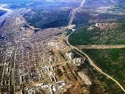 Aerial view of Ust-Kut | |
.svg.png) Location of Irkutsk Oblast in Russia | |
 Ust-Kut | |
|
| |
 |
|
|
| |
| Administrative status (as of July 2013) | |
| Country | Russia |
| Federal subject | Irkutsk Oblast[1] |
| Administrative district | Ust-Kutsky District[2] |
| Administrative center of | Ust-Kutsky District[3] |
| Municipal status (as of December 2012) | |
| Municipal district | Ust-Kutsky Municipal District[4] |
| Urban settlement | Ust-Kutskoye Urban Settlement[4] |
| Administrative center of | Ust-Kutsky Municipal District,[4] Ust-Kutskoye Urban Settlement[4] |
| Head | Vladimir Krivonosenko |
| Statistics | |
| Population (2010 Census) | 45,375 inhabitants[5] |
| Time zone | IRKT (UTC+08:00)[6] |
| Founded | 1631 |
| Town status since | 1954 |
| Postal code(s)[7] | 666781-666788, 666793 |
| Dialing code(s) | +7 39565 |
|
| |
| Ust-Kut on Wikimedia Commons | |
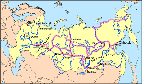
Ust-Kut (Russian: Усть-Кут) is a town and the administrative center of Ust-Kutsky District in Irkutsk Oblast, Russia, located 961 kilometers (597 mi) from Irkutsk, the administrative center of the oblast. Located on a western loop of the Lena River, the town spreads out for over 20 kilometers (12 mi) along the left bank, near the point where the Kuta River joins from the west. Population: 45,375 (2010 Census);[5] 49,951 (2002 Census);[8] 61,165 (1989 Census).[9]
Etymology
The town's name means "the mouth of the Kuta River" in Russian, with the name "Kuta" coming from an Evenk word meaning "peat bog".
History
It was founded in 1631 by Siberian Cossack ataman Ivan Galkin, who built an ostrog (fort) there. The fort's military importance declined in the latter half of the 17th century; however, the settlement was increasingly important as a river port, becoming one of the main starting points for trade along the Lena.
Mineral springs to the west of the town were reportedly discovered as early as the 17th century by Yerofey Khabarov and a spa was built at the site in 1925.
In the early 20th century Ust-Kut served as a destination for political exiles, most notably Leon Trotsky.
In 1951, the railway from Tayshet reached Ust-Kut. The town thus became the first and only river port on the Lena served by the railway and an important railhead through which cargoes could travel to and from the locations along the Lena, such as most of Yakutia. Ust-Kut was granted town status in 1954, with the merger of the original settlement of Ust-Kut and the river port suburb of Osetrovo.
Ust-Kut remained the end of the line until 1974, when construction work started to extend the railway, now known as the Baikal–Amur Mainline, east toward Lake Baikal and beyond. The town became the headquarters of the construction of the western section of the BAM.
Administrative and municipal status
Within the framework of administrative divisions, Ust-Kut serves as the administrative center of Ust-Kutsky District,[3] to which it is directly subordinated.[2] As a municipal division, the town of Ust-Kut, together with the selo of Turuka in Ust-Kutsky District, is incorporated within Ust-Kutsky Municipal District as Ust-Kutskoye Urban Settlement.[4]
Economy and infrastructure

Ust-Kut's economy relies mainly on its position as a transport hub, with the connection of road and rail transport with river traffic on the Lena. During the summer months, passenger ferries depart downriver from Ust-Kut to Yakutsk and Tiksi. There is a road bridge over the river in Ust-Kut.
There are also shipyards and food production in the town.
Ust-Kut is spread along the Baikal–Amur Mainline with multiple stations, including the smaller Ust-Kut station and the actual main station Lena near the river port in Osetrovo. At the small settlement of Yakurim a few kilometers further, the railway crosses the Lena via a 500-meter (1,600 ft) bridge, currently the last bridge across the river for its entire length.
The town is served by the Ust-Kut Airport, located 9 kilometers (5.6 mi) northwest of the town center.
References
Notes
- 1 2 Charter of Irkutsk Oblast
- 1 2 Registry of the Administrative-Territorial Formations of Irkutsk Oblast
- 1 2 Law #49-OZ
- 1 2 3 4 5 Law #93-oz
- 1 2 Russian Federal State Statistics Service (2011). "Всероссийская перепись населения 2010 года. Том 1" [2010 All-Russian Population Census, vol. 1]. Всероссийская перепись населения 2010 года (2010 All-Russia Population Census) (in Russian). Federal State Statistics Service. Retrieved June 29, 2012.
- ↑ Правительство Российской Федерации. Федеральный закон №107-ФЗ от 3 июня 2011 г. «Об исчислении времени», в ред. Федерального закона №271-ФЗ от 03 июля 2016 г. «О внесении изменений в Федеральный закон "Об исчислении времени"». Вступил в силу по истечении шестидесяти дней после дня официального опубликования (6 августа 2011 г.). Опубликован: "Российская газета", №120, 6 июня 2011 г. (Government of the Russian Federation. Federal Law #107-FZ of June 31, 2011 On Calculating Time, as amended by the Federal Law #271-FZ of July 03, 2016 On Amending Federal Law "On Calculating Time". Effective as of after sixty days following the day of the official publication.).
- ↑ Почта России. Информационно-вычислительный центр ОАСУ РПО. (Russian Post). Поиск объектов почтовой связи (Postal Objects Search) (Russian)
- ↑ Russian Federal State Statistics Service (May 21, 2004). "Численность населения России, субъектов Российской Федерации в составе федеральных округов, районов, городских поселений, сельских населённых пунктов – районных центров и сельских населённых пунктов с населением 3 тысячи и более человек" [Population of Russia, Its Federal Districts, Federal Subjects, Districts, Urban Localities, Rural Localities—Administrative Centers, and Rural Localities with Population of Over 3,000] (XLS). Всероссийская перепись населения 2002 года [All-Russia Population Census of 2002] (in Russian). Retrieved August 9, 2014.
- ↑ Demoscope Weekly (1989). "Всесоюзная перепись населения 1989 г. Численность наличного населения союзных и автономных республик, автономных областей и округов, краёв, областей, районов, городских поселений и сёл-райцентров" [All Union Population Census of 1989: Present Population of Union and Autonomous Republics, Autonomous Oblasts and Okrugs, Krais, Oblasts, Districts, Urban Settlements, and Villages Serving as District Administrative Centers]. Всесоюзная перепись населения 1989 года [All-Union Population Census of 1989] (in Russian). Институт демографии Национального исследовательского университета: Высшая школа экономики [Institute of Demography at the National Research University: Higher School of Economics]. Retrieved August 9, 2014.
Sources
- Законодательное Собрание Иркутской области. Постановление №9/5-ЗС от 15 апреля 2009 г. «Устав Иркутской области», в ред. Закона №2-У от 7 июля 2015 г. «О поправках к Уставу Иркутской области». Вступил в силу по истечении десяти дней после дня официального опубликования. Опубликован: "Областная", №45, 24 апреля 2009 г. (Legislative Assembly of Irkutsk Oblast. Resolution #9/5-ZS of April 15, 2009 Charter of Irkutsk Oblast, as amended by the Law #2-U of July 7, 2015 On Amending the Charter of Irkutsk Oblast. Effective as of the day following a ten-day period after the day of the official publication.).
- Законодательное Собрание Иркутской области. Закон №49-ОЗ от 21 июня 2010 г. «Об административно-территориальном устройстве Иркутской области», в ред. Закона №183-ОЗ от 31 декабря 2014 г. «Об отдельных вопросах административно-территориального устройства Иркутской области и о внесении изменений в Закон Иркутской области "Об административно-территориальном устройстве Иркутской области"». Вступил в силу после дня официального опубликования. Опубликован: "Областная", №71, 25 июня 2010 г. (Legislative Assembly of Irkutsk Oblast. Law #49-OZ of June 21, 2010 On the Administrative-Territorial Structure of Irkutsk Oblast, as amended by the Law #183-OZ of December 31, 2014 On Various Issues Regarding the Administrative-Territorial Structure of Irkutsk Oblast and on Amending the Law of Irkutsk Oblast "On the Administrative-Territorial Structure of Irkutsk Oblast". Effective as of after the day of the official publication.).
- Законодательное Собрание Иркутской области. Закон №93-оз от 16 декабря 2004 г. «О статусе и границах муниципальных образований Усть-Кутского района Иркутской области», в ред. Закона №128-ОЗ от 3 декабря 2012 г. «О внесении изменений в Закон Иркутской области "О статусе и границах муниципальных образований Усть-Кутского района Иркутской области"». Вступил в силу с 31 декабря 2004 г., но не ранее чем через 10 дней со дня официального опубликования. Опубликован: "Восточно-Сибирская правда", №254–255, 20 декабря 2004 г. (Legislative Assembly of Irkutsk Oblast. Law #93-oz of December 16, 2004 On the Status and Borders of the Municipal Formations of Ust-Kutsky District of Irkutsk Oblast, as amended by the Law #128-OZ of December 3, 2012 On Amending the Law of Irkutsk Oblast "On the Status and Borders of the Municipal Formations of Ust-Kutsky District of Irkutsk Oblast". Effective as of December 31, 2004, but not earlier than 10 days after the official publication date.).