Kyakhta
| Kyakhta (English) Кяхта (Russian) Хяагта (Buryat) | |
|---|---|
| - Town[1] - | |
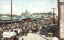
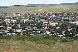 View of the town | |
.svg.png) Kyakhta | |
|
| |
_(1861).png) |
|
|
| |
| Administrative status (as of July 2013) | |
| Country | Russia |
| Federal subject | Republic of Buryatia[1] |
| Administrative district | Kyakhtinsky District[1] |
| Town | Kyakhta[1] |
| Administrative center of | Kyakhtinsky District,[1] Town of Kyakhta[1] |
| Municipal status (as of October 2014) | |
| Municipal district | Kyakhtinsky Municipal District[2] |
| Urban settlement | Kyakhta Urban Settlement[2] |
| Administrative center of | Kyakhtinsky Municipal District,[2] Kyakhta Urban Settlement[2] |
| Mayor | Valery Tsyrempilov |
| Statistics | |
| Population (2010 Census) | 20,024 inhabitants[3] |
| Time zone | IRKT (UTC+08:00)[4] |
| Founded | 1728[5] |
| Town status since | 1805 |
| Previous names |
Kyakhta, Troitskosavsk (until 1935) |
| Postal code(s)[6] | 671840, 671842, 671843 |
| Dialing code(s) | +7 30142 |
| Kyakhta on Wikimedia Commons | |
Kyakhta (Russian: Кя́хта; Buryat: Хяагта, Khyaagta) is a town and the administrative center of Kyakhtinsky District in the Republic of Buryatia, Russia, located on the Kyakhta River near the Mongolia–Russia border. The town stands directly opposite the Mongolian border town of Altanbulag. Population: 20,041 (2010 Census);[3] 18,391 (2002 Census);[7] 18,307 (1989 Census).[8] From 1727 it was the border crossing for the Kyakhta trade between Russia and China.
Etymology
The Buryat name means place covered with couch grass,[9] and is derived from Mongolian word хиаг, meaning couch grass.[10]
Geography
The region where Kyakhta stands is a natural location for Russo-Chinese trade. The Siberian River Routes connect the fur-bearing lands of Siberia to Lake Baikal. From there, the Selenga River valley is the natural route through the mountains southeast of Lake Baikal out onto the plains of Mongolia.
History
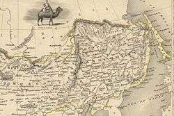
Kyakhta was founded in 1727 soon after the Treaty of Kyakhta was negotiated just north at Selenginsk. It was the starting point of the boundary markers that defined what is now the northern border of Mongolia. Kyakhta's founder, Serb Sava Vladislavich, established it as a trading point between Russia and the Qing Empire.[5] The Manchus built Maimaicheng just south of Kyakhta on their side of the border. Before 1762, state caravans traveled from Kyakhta to Peking. After that date, trade was mostly by barter at Kyakhta-Maimaicheng, with merchants crossing the border to make their business.
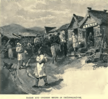
Kyakhta and Maimaicheng were visited by the famous English adventurer and engineer Samuel Bentham in 1782. He related that he was entertained by the commander of the Chinese city "with the greatest politeness which a stranger can meet with in any country whatever". At that time, the Russians sold furs, textiles, clothing, hides, leather, hardware, and cattle, while the Chinese sold silk, cotton stuffs, teas, fruits, porcelain, rice, candles, rhubarb, ginger, and musk. Much of the tea is said to have come from Yangloudong, a major center of tea production and trade near today's Chibi City, Hubei.[11]
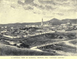
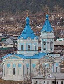
Kyakhta was crowded, unclean, ill-planned, and never came to reflect the wealth that flowed through it,[12] although several Neoclassical buildings were erected in the 19th century, including a tea bourse (1842) and the Orthodox cathedral (1807–1817), both of which still stand. In 1996 the Voskreskenskaya church was being used a stable.[13] It was from Kyakhta that Nikolay Przhevalsky, Grigory Potanin, Pyotr Kozlov, and Vladimir Obruchev set off on their expeditions into the interior of Mongolia and Xinjiang.
Town status was granted to Kyakhta in 1805.
After the entire Russian-Chinese frontier was opened to trade in 1860 and the Trans-Siberian and the Chinese Eastern Railways bypassed it, Kyakhta fell into decline. The town was renamed Troitskosavsk during the first part of the 20th century, but the original name was restored in 1935. Another source[14] has Troitskosavsk as a fort a short distance north, Troitskosavsk being the administrative and military center while Kyakhta was the trading post on the border.
In the mid-20th century, a branch railway was built from Ulan-Ude (on the Trans-Siberian) to Mongolia's Ulan Bator, and, eventually, to China, paralleling the old Kyakhta trade route. However, this railway crosses the Russian-Mongolian border not in Kyakhta itself, but in nearby Naushki.[15]
Kyakhta Pidgin
As the first market town on the border between the Russian and Chinese Empires, Kyakhta gave its name to the so-called Kyakhta Russian–Chinese Pidgin, a contact language that was used by Russian and Chinese traders to communicate.[16]
Administrative and municipal status
Within the framework of administrative divisions, Kyakhta serves as the administrative center of Kyakhtinsky District.[1] As an administrative division, it is, together with one rural locality (the settlement of Sudzha), incorporated within Kyakhtinsky District as the Town of Kyakhta.[1] As a municipal division, the Town of Kyakhta is incorporated within Kyakhtinsky Municipal District as Kyakhta Urban Settlement.[2]
Economy
Kyakhta's economy today relies mainly on its status as an important center for trade between Russia, China, and Mongolia, located on the highway from the republic's capital of Ulan-Ude to the Mongolian capital of Ulan Bator. It also has textile, lumber, and food-processing plants.
Culture
Kyakhta is home to the Damdin Sükhbaatar memorial museum.
Climate
Kyakhta has a borderline subarctic climate (Köppen climate classification Dwc) and humid continental climate (Köppen climate classification Dwb), with dry, severely cold winters and warm, moist summers.
| Climate data for Kyakhta | |||||||||||||
|---|---|---|---|---|---|---|---|---|---|---|---|---|---|
| Month | Jan | Feb | Mar | Apr | May | Jun | Jul | Aug | Sep | Oct | Nov | Dec | Year |
| Record high °C (°F) | −0.1 (31.8) |
8.6 (47.5) |
20.5 (68.9) |
29.3 (84.7) |
35.0 (95) |
37.2 (99) |
40.6 (105.1) |
37.1 (98.8) |
31.5 (88.7) |
26.6 (79.9) |
11.8 (53.2) |
5.4 (41.7) |
40.6 (105.1) |
| Average high °C (°F) | −15.8 (3.6) |
−10.7 (12.7) |
−0.9 (30.4) |
9.5 (49.1) |
17.5 (63.5) |
23.7 (74.7) |
25.1 (77.2) |
22.9 (73.2) |
16.2 (61.2) |
7.5 (45.5) |
−4.8 (23.4) |
−13.5 (7.7) |
6.39 (43.52) |
| Daily mean °C (°F) | −21.3 (−6.3) |
−17.3 (0.9) |
−7.9 (17.8) |
2.4 (36.3) |
10.0 (50) |
16.7 (62.1) |
19.1 (66.4) |
16.6 (61.9) |
9.4 (48.9) |
0.8 (33.4) |
−10.1 (13.8) |
−18.7 (−1.7) |
−0.02 (31.96) |
| Average low °C (°F) | −26.1 (−15) |
−23.0 (−9.4) |
−14.0 (6.8) |
−4.2 (24.4) |
2.7 (36.9) |
9.6 (49.3) |
13.2 (55.8) |
10.8 (51.4) |
3.6 (38.5) |
−4.6 (23.7) |
−15.1 (4.8) |
−23.2 (−9.8) |
−5.86 (21.45) |
| Record low °C (°F) | −55.2 (−67.4) |
−49.1 (−56.4) |
−39.7 (−39.5) |
−27.4 (−17.3) |
−12.1 (10.2) |
−4.5 (23.9) |
1.4 (34.5) |
−2.7 (27.1) |
−9.7 (14.5) |
−26.8 (−16.2) |
−34.7 (−30.5) |
−42.1 (−43.8) |
−55.2 (−67.4) |
| Average precipitation mm (inches) | 4.0 (0.157) |
3.3 (0.13) |
4.7 (0.185) |
11.9 (0.469) |
26.4 (1.039) |
58.7 (2.311) |
86.2 (3.394) |
75.2 (2.961) |
38.7 (1.524) |
13.2 (0.52) |
6.6 (0.26) |
4.4 (0.173) |
333.3 (13.123) |
| Average precipitation days (≥ 0.1 mm) | 10.7 | 6.3 | 7.2 | 7.8 | 10.7 | 10.4 | 11.9 | 12.1 | 9.6 | 8.0 | 8.3 | 9.4 | 112.4 |
| Average relative humidity (%) | 79.1 | 73.9 | 65.8 | 53.0 | 53.0 | 58.7 | 64.1 | 68.0 | 66.5 | 68.0 | 73.9 | 79.1 | 66.93 |
| Mean monthly sunshine hours | 158.1 | 187.6 | 235.6 | 243.0 | 275.9 | 276.0 | 279.0 | 254.2 | 234.0 | 186.0 | 153.0 | 127.1 | 2,609.5 |
| Source: climatebase.ru (1948-2011)[17] | |||||||||||||
Town name in other languages
- Mongolian: Хиагт (Khiagt)
- Manchu: Kiyaktu
- Chinese: 恰克图 / 恰克圖 (Qiàkètú) or 恰克土 (Qiàkètǔ)
- Buryat: Хяагта (Khyaagta)
In Mongolian, Kyakhta was formerly known as Ар Хиагт (Ar Khiagt, lit. "North Kyakhta"); Altanbulag (then, Maimaicheng) across the border was Өвөр Хиагт (Övör Khiagt, lit. "South Kyakhta"). When the town was known as Troitskosavsk, its name in Mongolian was Дээд Шивээ (Deed Šhivee).
References
Notes
- 1 2 3 4 5 6 7 8 Resolution #43
- 1 2 3 4 5 Law #985-III
- 1 2 Russian Federal State Statistics Service (2011). "Всероссийская перепись населения 2010 года. Том 1" [2010 All-Russian Population Census, vol. 1]. Всероссийская перепись населения 2010 года (2010 All-Russia Population Census) (in Russian). Federal State Statistics Service. Retrieved June 29, 2012.
- ↑ Правительство Российской Федерации. Федеральный закон №107-ФЗ от 3 июня 2011 г. «Об исчислении времени», в ред. Федерального закона №271-ФЗ от 03 июля 2016 г. «О внесении изменений в Федеральный закон "Об исчислении времени"». Вступил в силу по истечении шестидесяти дней после дня официального опубликования (6 августа 2011 г.). Опубликован: "Российская газета", №120, 6 июня 2011 г. (Government of the Russian Federation. Federal Law #107-FZ of June 31, 2011 On Calculating Time, as amended by the Federal Law #271-FZ of July 03, 2016 On Amending Federal Law "On Calculating Time". Effective as of after sixty days following the day of the official publication.).
- 1 2 Mark Mancall (1971). Russia and China: their diplomatic relations to 1728, (Volume 61 of Harvard East Asian series, Center for East Asian Studies, Harvard University). Harvard University Press. p. 263.
- ↑ Почта России. Информационно-вычислительный центр ОАСУ РПО. (Russian Post). Поиск объектов почтовой связи (Postal Objects Search) (Russian)
- ↑ Russian Federal State Statistics Service (May 21, 2004). "Численность населения России, субъектов Российской Федерации в составе федеральных округов, районов, городских поселений, сельских населённых пунктов – районных центров и сельских населённых пунктов с населением 3 тысячи и более человек" [Population of Russia, Its Federal Districts, Federal Subjects, Districts, Urban Localities, Rural Localities—Administrative Centers, and Rural Localities with Population of Over 3,000] (XLS). Всероссийская перепись населения 2002 года [All-Russia Population Census of 2002] (in Russian). Retrieved August 9, 2014.
- ↑ Demoscope Weekly (1989). "Всесоюзная перепись населения 1989 г. Численность наличного населения союзных и автономных республик, автономных областей и округов, краёв, областей, районов, городских поселений и сёл-райцентров" [All Union Population Census of 1989: Present Population of Union and Autonomous Republics, Autonomous Oblasts and Okrugs, Krais, Oblasts, Districts, Urban Settlements, and Villages Serving as District Administrative Centers]. Всесоюзная перепись населения 1989 года [All-Union Population Census of 1989] (in Russian). Институт демографии Национального исследовательского университета: Высшая школа экономики [Institute of Demography at the National Research University: Higher School of Economics]. Retrieved August 9, 2014.
- ↑ Pospelov, p. 234
- ↑ Ирина Ф. Попова. "Торговля России и Китая через Кяхту и Маймайчен", in Mongolica-XI (SPb., 2013), p. 28, fn. 1.
- ↑ Li Baihao; Zhu Jianhua; Huang Li; Guo Jian (2005), "One cultural route span the Millenary: Chinese Tea Road", Proceedings of the Scientific Symposium "Monuments and sites in their setting - conserving cultural heritage in changing townscapes and landscapes" (PDF), Xi'an, p. 4
- ↑ W. Bruce Lincoln. The Conquest of a Continent: Siberia and the Russians. Cornell University Press, 2007. Page 145.
- ↑ Martha Avery,The Tea Road, 2003, page 135 and photograph
- ↑ Clifford M Foust, 'Muscovite and Mandarin', 1969, index
- ↑ Rolf Potts, Stranded in Siberia: At an obscure border town, our correspondent discovers the biggest obstacle in negotiating the next 4,000 miles: The train has left without him. (Salon Magazine, 1999-11-10)
- ↑ International Council for Philosophy and Humanistic Studies (1996). Atlas of languages of intercultural communication in the Pacific, Asia, and the Americas, Volume 2, Part 1. (Volume 13 of Trends in Linguistics, Documentation Series). Walter de Gruyter. pp. 911–912. ISBN 3-11-013417-9.
- ↑ "Kyakhta, Russia". Climatebase.ru. Retrieved January 24, 2013.
Sources
- Правительство Республики Бурятия. Постановление №431 от 18 ноября 2009 г. «О реестре административно-территориальных единиц и населённых пунктов Республики Бурятия», в ред. Постановления №573 от 13 ноября 2015 г. «О внесении изменений в Постановление Правительства Республики Бурятия от 18.11.2009 №431 "О реестре административно-территориальных единиц и населённых пунктов Республики Бурятия"». Вступил в силу 18 ноября 2009 г. Опубликован: "Бурятия", №216, Официальный вестник №120, 21 ноября 2009 г. (Government of the Republic of Buryatia. Resolution #431 of November 18, 2009 On the Registry of the Administrative-Territorial Units and the Inhabited Localities of the Republic of Buryatia, as amended by the Resolution #573 of November 13, 2015 On Amending Resolution #431 of November 18, 2009 of the Government of the Republic of Buryatia "On the Registry of the Administrative-Territorial Units and the Inhabited Localities of the Republic of Buryatia". Effective as of November 18, 2009.).
- Народный Хурал Республики Бурятия. Закон №985-III от 31 декабря 2004 г. «Об установлении границ, образовании и наделении статусом муниципальных образований в Республике Бурятия», в ред. Закона №1411-V от 14 октября 2015 г. «О внесении изменений в Закон Республики Бурятия "Об установлении границ, образовании и наделении статусом муниципальных образований в Республике Бурятия"». Вступил в силу со дня официального опубликования. Опубликован: "Бурятия", №1, Официальный вестник №1, 12 января 2005 г. (People's Khural of the Republic of Buryatia. Law #985-III of December 31, 2004 On Establishing the Borders, Creating, and Granting a Status to the Municipal Formations in the Republic of Buryatia, as amended by the Law #1411-V of October 14, 2015 On Amending the Law of the Republic of Buryatia "On Establishing the Borders, Creating, and Granting a Status to the Municipal Formations in the Republic of Buryatia". Effective as of the day of the official publication.).
- Е. М. Поспелов (Ye. M. Pospelov). "Географические названия мира" (Geographic Names of the World). Moscow, 1998.
- Christie, Ian R. (1993). The Benthams in Russia 1780–1791. Oxford, UK; Providence, RI: Berg Publishers Limited. ISBN 0-85496-816-4. OCLC 25833658.
 This article incorporates text from a publication now in the public domain: Chisholm, Hugh, ed. (1911). "article name needed". Encyclopædia Britannica (11th ed.). Cambridge University Press.
Capital: Ulan-Ude | |||
| Districts | |||
| Cities and towns (all levels) | |||
| Urban-type settlements | |||