Sequeira, Uruguay
| Sequiera Pueblo Sequiera | |
|---|---|
| Populated rural area | |
 Sequiera Location in Uruguay | |
| Coordinates: 31°2′0″S 56°52′0″W / 31.03333°S 56.86667°WCoordinates: 31°2′0″S 56°52′0″W / 31.03333°S 56.86667°W | |
| Country |
|
| Department | Artigas Department |
| Population (2011) | |
| • Total | 1,149 |
| Time zone | UTC - 3 |
| Postal code | 55007 |
| Dial plan | +598 4776 (+4 digits) |
Sequiera is a village ("pueblo") in the south of the Artigas Department in northwestern Uruguay.
Location
It is located on Km.125 of Route 4, about 80 kilometres (50 mi) south-southwest of Artigas, the capital of the department, and 127 kilometres (79 mi) east-northeast of Salto, the capital of the Salto Department.
Geography
It is situated between the streams Arroyo Sequeira to the east and Zanja de los Talas to the west, both tributaries of Río Arapey Chico, which flows 4.5 kilometres (2.8 mi) south of the populated area.
History
The name comes from the Guaraní-mission commander Ramón Sequeira, who in 1832 rebelled against the government of Fructuoso Rivera. On June 5 of that year Sequeira was surprised and defeated by troops led by Bernabé Rivera on the Arapey Chico.
In 1997 a tornado swept through the town, destroyed traditional wood and mud huts Sequeira was completely rebuilt with more solid buildings that are distributed on both sides of Route 4.
Its status was elevated to "Pueblo" (village) by the Act of Ley 17.413 on 2 November 2001.[1]
Population
In 2011, Sequiera had a population of 1149.[2]
| Year | Population |
|---|---|
| 1963 | 880 |
| 1975 | 802 |
| 1985 | 650 |
| 1996 | 877 |
| 2004 | 970 |
| 2011 | 1,149 |
Source: Instituto Nacional de Estadística de Uruguay[3]
Life expectancy
Sequeira is noted for having an unusually high number of centenarians. In 2003 these were Marta Caballero (102), Augusta Rodríguez Mezquita (113), Francisca Paz (101), Maneca Tejeira (106) and Bartolo Díaz (106).
Economy
It is a major service centre for sheep farming.
References
- ↑ "LEY N° 17.413". República Oriental del Uruguay, Poder Legislativo. 2001. Retrieved 3 September 2012.
- ↑ "Censos 2011 Cuadros Artigas". INE. 2012. Retrieved 25 August 2012.
- ↑ "Statistics of urban localities (1963–2004)" (PDF). INE. 2012. Retrieved 3 September 2012.
External links
Capital: Artigas | ||
| Towns and villages | 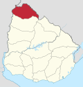 | |
| Sights | ||