Bernabé Rivera
| Bernabé Rivera | |
|---|---|
| Village | |
 Bernabé Rivera Location in Uruguay | |
| Coordinates: 30°18′0″S 56°58′0″W / 30.30000°S 56.96667°WCoordinates: 30°18′0″S 56°58′0″W / 30.30000°S 56.96667°W | |
| Country |
|
| Department | Artigas Department |
| Time zone | UTC - 3 |
| Postal code | 55004 |
| Dial plan | +598 4778 (+4 digits) |
Bernabé Rivera is a village in the Artigas Department of northern Uruguay.
Location
The village is located 20 kilometres (12 mi) northeast into a secondary road leaving off Route 30 at about 60 kilometres (37 mi) west of the department capital Artigas and joining it with the village Topador before returning to Route 30 at a point about 23 kilometres (14 mi) west of Artigas.
Geography
It is situated south of the hill Cuchilla del Yacaré and north of the stream Arroyo Tres Cruces.
History
Its earlier name was "Allende" or "Yacaré", and on 26 May 1924, it was declared a "Pueblo" (village) by the Act of Ley Nº 7.720.[1] It was renamed to "Bernabé Rivera" on 11 January 1956 by the Act of Ley Nº 12.271.[2]
Population
In 2011 Bernabe Rivera had a population of 380.[3]
| Year | Population |
|---|---|
| 1908 | 1,954 |
| 1963 | 683 |
| 1975 | 540 |
| 1985 | 461 |
| 1996 | 421 |
| 2004 | 524 |
| 2011 | 380 |
Source: Instituto Nacional de Estadística de Uruguay[1]
References
- 1 2 "Statistics of urban localities (1908–2004) (see also "Allende" & "Yacaré")" (PDF). INE. 2012. Retrieved 6 September 2012.
- ↑ "Ley Nº 12.271". República Oriental del Uruguay, Poder Legislativo. 1956. Retrieved 6 September 2012.
- ↑ "Censos 2011 Artigas (needs flash plugin)". INE. 2012. Retrieved 25 August 2012.
External links
Capital: Artigas | ||
| Towns and villages | 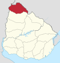 | |
| Sights | ||