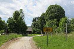
Seč, Kočevje
| Seč | |
|---|---|
 | |
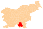
 Seč Location in Slovenia | |
| Coordinates: 45°45′1.73″N 14°51′4.59″E / 45.7504806°N 14.8512750°ECoordinates: 45°45′1.73″N 14°51′4.59″E / 45.7504806°N 14.8512750°E | |
| Country |
|
| Traditional region | Lower Carniola |
| Statistical region | Southeast Slovenia |
| Municipality | Kočevje |
| Area | |
| • Total | 4.79 km2 (1.85 sq mi) |
| Elevation | 375 m (1,230 ft) |
| Population (2002) | |
| • Total | 0 |
| [1] | |
Seč (pronounced [ˈseːtʃ]; German: Setsch[2][3]) is an abandoned settlement in the Municipality of Kočevje in southern Slovenia. It was a village inhabited by Gottschee Germans. In 1941, during the Second World War its original population was expelled. The area is part of the traditional region of Lower Carniola and is now included in the Southeast Slovenia Statistical Region.[4]
Church

Saint Agnes' Church
The local church is dedicated to Saint Agnes (Slovene: sveta Neža) and was built in 1837. Its interior furnishings were destroyed after the Second World War. It was restored in the early 1980s.[5]
References
- ↑ Statistical Office of the Republic of Slovenia
- ↑ Leksikon občin kraljestev in dežel zastopanih v državnem zboru, vol. 6: Kranjsko. 1906. Vienna: C. Kr. Dvorna in Državna Tiskarna, p. 40.
- ↑ Ferenc, Mitja. 2007. Nekdanji nemški jezikovni otok na kočevskem. Kočevje: Pokrajinski muzej, p. 4.
- ↑ Kočevje municipal site
- ↑ Slovenian Ministry of Culture register of national heritage reference number ešd 2152
External links
| Wikimedia Commons has media related to Seč. |
This article is issued from Wikipedia - version of the 8/17/2014. The text is available under the Creative Commons Attribution/Share Alike but additional terms may apply for the media files.