Sawteeth (New York)
| Sawteeth | |
|---|---|
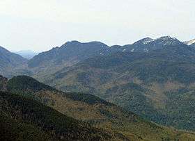 Ausable Valley, Sawteeth (left), Pyramid and Gothics (right) | |
| Highest point | |
| Elevation | 1,265 metres (4,150 ft)[1] |
| Prominence | 150 m (490 ft)[2] |
| Listing | Adirondack High Peaks |
| Coordinates | 44°6.80′N 73°51.04′W / 44.11333°N 73.85067°WCoordinates: 44°6.80′N 73°51.04′W / 44.11333°N 73.85067°W |
| Geography | |
| Location | Keene, Essex County, New York |
| Parent range | the Great Range |
| Topo map | USGS Mount Marcy |
Sawteeth (sometimes Resagonia Mountain or Sawtooth) is a mountain located in Essex County, New York. The mountain is part of the Great Range of the Adirondack Mountains. The mountain's name comes from the serrated appearance of its summit ridge. Sawteeth is on a spur ridge of the Great Range, which branches off to the southeast from Gothics.
Sawteeth stands within the watershed of the East Branch of the Ausable River, which drains into Lake Champlain, thence into Canada's Richelieu River, the Saint Lawrence River, and into the Gulf of Saint Lawrence. The west side and south end of Sawteeth drain into Shanty Brook, thence into the East Branch of the Ausable River between Upper and Lower Ausable Lake. The east side and north end of Sawteeth drain into Cascade Brook, thence into the East Branch below Lower Ausable Lake.
Sawteeth is within the High Peaks Wilderness Area of Adirondack Park, and entirely within the Adirondack Mountain Reserve (property of the Ausable Club).
See also
- List of mountains in New York
- Northeast 111 4,000-footers
- Adirondack High Peaks
- Adirondack Forty-Sixers
Notes
External links
- Peakbagger.com: Sawteeth
- Summitpost.org: Sawteeth
- U.S. Geological Survey Geographic Names Information System: Sawteeth