Wright Peak
| Wright Peak | |
|---|---|
 | |
| Highest point | |
| Elevation | 4,587 feet (1,398 metres) |
| Prominence | 270 ft (80 m)[1] |
| Listing | Adirondack High Peaks |
| Coordinates | 44°09′06″N 73°58′49″W / 44.15167°N 73.98028°WCoordinates: 44°09′06″N 73°58′49″W / 44.15167°N 73.98028°W |
| Geography | |
| Location | North Elba, New York, U.S. |
| Parent range | MacIntyre Range |
| Topo map | USGS Keene Valley |
| Climbing | |
| Easiest route | Hike from the Adirondak Loj |
Wright Peak is the 16th highest peak in the High Peaks of the Adirondack Park, and is located in the MacIntyre Range in the town of North Hudson, in Essex County, New York. Named for N.Y. Governor Silas Wright (1795–1847), Wright is the northern-most peak in the MacIntyre Range, and is known to be one of the windiest peaks in the park, as well as one of the best for back-country skiing. There are long slides from the summit that lead to Marcy Dam which are often skied in the winter.
The usual approach to Wright Peak is from the Adirondak Loj, heading 1.3 miles (2.1 km) up the Van Hovenberg trail, then ascending the steep MacIntyre Range Trail to the junction for Algonquin Peak; a left turn takes the climber .4 miles and up the last few hundred feet of elevation through the alpine zone. Wright is often hiked in conjunction with Algonquin and sometimes Iroquois Peak by peakbaggers, making for one of the toughest hikes in the region.
B-47 crash site
On January 16, 1962, a B-47 bomber on a training mission crashed into Wright Peak, killing all four crewmen. Their training mission involved practicing low bombing runs over Watertown, NY. Due to inclement weather, the bomber veered about 30 miles off course, and into the High Peaks region. The aircraft made its impact just feet below the summit of Wright Peak. Pieces of the wreckage can still be found on the summit, along with a plaque near the impact site. Some of the crash debris is quite large, and hikers making the trip to the summit have been known to take small pieces down with them as souvenirs.[2]
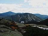 Mount Colden from Wright, Marcy at left
 Wright Peak as seen from Marcy Dam (note snow-covered Marcy Dam Pond, foreground)
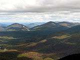
Notes
- ↑ Key col elevation between 1,310 and 1,320 m.
- ↑ An Air Force Bomber Crashes into Wright Peak http://www.adirondack-park.net/history/b47.wright.html
External links
- U.S. Geological Survey Geographic Names Information System: Wright Peak
- Peakbagger.com: Wright Peak
- Summitpost.org: Wright Peak
- Crash of the Wright Peak B-47