Richelieu River
| Richelieu River | |
|---|---|
|
Richelieu River at Saint-Marc-sur-Richelieu | |
| Country |
Canada, and appreciable parts of New York State and Vermont |
| Basin | |
| Main source | Lake Champlain |
| River mouth | Saint Lawrence River at Sorel |
| Basin size | 23,720 km2 (9,160 sq mi) |
| Physical characteristics | |
| Length | 124 km (77 mi) |
| Discharge |
|


The Richelieu River takes its source in Lake Champlain, from which it flows to the north in the province of Quebec, Canada and empties into the St. Lawrence river. It was formerly known as the Iroquois River and the Chambly River.[1] This river was a key route of water transport for cross-border trade between Canada and the United States, until the arrival of the railway in the mid-19th century.
Because of its strategic position between New France and New England, several military fortifications were erected on the course of the river. It served as a key pathway for several military tours and was the scene of several battles between the end of the 17th and early 19th centuries, first between the French and the Iroquois, then between the French and the English, during the regime of the New France and finally between the English and the Americans after 1760.
Geography and hydrography
The Richelieu River has a drainage basin of 23,720 square kilometres (9,160 sq mi)2 - including those of Lake Champlain 19,925 km2 (7,693 sq mi)[2] and Missisquoi Bay (1 289 km2). Of this, 19,600 km2 (7,600 sq mi)[2] are in the United States, originating in the western slopes of the Green Mountains and the eastern slopes of the Adirondack Mountains of New York State. The Champlain Valley makes up most of the drainage basin.
With a length of 124 km (77 mi), the Richelieu River takes its source at the north end of Lake Champlain on the border between Canada (Quebec) and the United States (Vermont and New York state). The river flows through many towns: Lacolle, Île aux Noix, Saint-Jean-sur-Richelieu, Chambly, Beloeil, Saint-Charles-sur-Richelieu, Saint-Denis-sur-Richelieu, Saint-Ours and Sorel-Tracy where the river empties into the Saint Lawrence River, around 40 km northeast of Montreal and southwest of Quebec City.[2]
The Richelieu River is the largest tributary of the south shore of Saint Lawrence River and drains a large area of southern Quebec. The Quebec portion of the watershed (about 15% of its total area) includes 18 lakes and ponds, as well as forty rivers and tributary streams of the Richelieu. The main Richelieu tributaries are rivers: Acadia, South Huron and Lacolle.[3][4] The river's mean discharge is 330 cubic metres per second (12,000 cu ft/s).[5]
Nearly 340,000 people across eight Regional county municipalities (RCM in English or MRC in French) and 65 municipalities, live in the Quebec portion of the watershed of the river. The population density (140 inhabitants per km2) is very high compared to that of most other regions of the province of Quebec. Just over 70% of this area is used for agricultural purposes.[4]
With the opening of the Chambly Canal in 1843, navigation became possible on the Richelieu between the St. Lawrence River and Lake Champlain. At the southern end of the lake, the Champlain Canal (opened in 1823) allows for navigation to the Hudson River and, downstream, the city of New York, where the river flows into the Atlantic Ocean.
Saint-Jean-sur-Richelieu, Chambly, Beloeil, Mont-Saint-Hilaire, and Sorel-Tracy are important communities on its route.
River course and hydrology
The average slope of the Richelieu River is 0.19 m/km, but 24 meters in elevation between Saint-Jean-sur-Richelieu and Chambly for an average flow of 330 cubic meters per second.[6]
By convention, the Richelieu is generally divided into three main sections:[7]
- The Haut-Richelieu (upper Richelieu, between Lake Champlain and Saint-Jean-sur-Richelieu). It is characterized by a very low drop (0.3 m over 35 km). With a width of about 1.5 km at its southern end, it becomes increasingly narrow (width of about 250 m in its most narrow areas). It passes through the city of Saint-Jean-sur-Richelieu, which now includes Iberville and Saint-Luc (merged in 2001).
- The Chambly Canal (of Saint-Jean-sur-Richelieu to Chambly). Due to its significant drop in this area - 25 m over 12 km - the river has many rapids. The channel consists of nine locks and a length of nearly 19 km, allowing boats to navigate past the rapids.[8] In Chambly, the river widens and forms the Chambly Basin, a popular area for nautical activities.
- The Bas-Richelieu (lower Richelieu, between Chambly and St. Lawrence River). In this section, the river passes the cities of Otterburn Park of Beloeil, the Mont-Saint-Hilaire and municipalities McMasterville of Saint-Charles-sur-Richelieu and Saint-Denis-sur-Richelieu. In Saint-Ours, the river is again characterized by a sudden drop before emptying into the St. Lawrence River at Sorel-Tracy, southwest of Lake Saint-Pierre.
Several river islands are along the route of the Richelieu River. Arguably the most famous, "Île aux Noix" is in the Haut-Richelieu and houses Fort Lennox, considered a national historic site of Canada.[9] Downstream, the Sainte-Thérèse Island near Saint-Jean-sur-Richelieu (in Saint-Luc's sector), is the largest island on the Richelieu (its length is about 4 km and a maximum width of 1 km). Formerly agricultural, it is now largely residential. It also previously housed the Fort Sainte Thérèse, built in 1665, but abandoned at the end of the 18th century and now disappeared.
Le Richelieu is one of three rivers flowing from Quebec south to north, the other two being the Châteauguay and Chaudière. Ice jams can form in the spring with the melting of ice in the south while the north is still frozen, causing floods.[10]
Tributaries in Quebec part
- L'Acadie River (Rivière l'Acadie),[11] 82 km. Mouth: Carignan.
- South River (Rivière Du Sud), 39.1 km. Mouth: Henryville.
- Amyot River (Rivière Amyot), 11.7 km. Mouth: Saint-Charles-sur-Richelieu.
- Lacolle River (Rivière Lacolle), 24 km. Mouth: Lacolle.
- Hurons River (Rivière Des Hurons), 33 km. Mouth: Saint-Mathias-sur-Richelieu.
- Iroquois River (Rivière Des Iroquois), 10.1 km. Mouth: Saint-Jean-sur-Richelieu.
- Bernier River (Rivière Bernier), 12.9 km. Mouth: Saint-Jean-sur-Richelieu.
- Massé Stream (Ruisseau Massé). Mouth: Carignan.
- Bernard Stream East (Ruisseau Bernard). Mouth: Otterburn Park.
- Bernard Stream West (Ruisseau Bernard). Mouth: McMasterville.
- North Stream (Ruisseau Nord) in (Saint-Mathieu-de-Beloeil)
- South Stream (Ruisseau Sud) in (Saint-Mathieu-de-Beloeil)
Geology
The valley of the Richelieu river is based on sedimentary rocks formed during the Cambrian of the Paleozoic era around 450 million years ago. The bedrock consists of shale clay and sandstone. The shales are sedimentary rocks from the mechanical disintegration of preexisting rocks. The sandstones are composed of quartz grains joined together and are always the result of deposition of shoreline.
The Utica shale usually contain an abundance of mica flakes and important content of quartz. The Utica shale is especially conducive to the shale gas exploitation. Those of Lorraine group are dark gray color, and contain also sandstone lenses up to 5 cm thick. These are the rocks of the Lorraine Group (sub-formation Breault) that cover most of the area. This group (sub-formation Chambly) contains the younger sedimentary rocks of the region: a series of shales and "calcaireuses" that turn red in the upper parts.[12]
Historically, the formation of rocks in the region is due to its immersion, towards the end of the Ordovician geological era, which led to the establishment of marine sediments. Then raised by tectonic forces, the entire region has been subjected to a long erosion since the end of the Ordovician to the late Tertiary. Subsequently, after being covered with a thick layer of ice during the Quaternary, the lowlands of the St. Lawrence was overwhelmed by the Champlain Sea in the wake of the collapse of the foundation underlying therefore the weight of glaciers. After dropping clays and sands, the sea had to decline, following the recovery of the base, and left the area in its current state.
The valley has a few pronounced relief that is covered with a large clay deposit of up to 50 meters thick. The lowlands were once part of plain of alluviums of St. Lawrence valley, greater than it is today. In a relatively recent geological time, glaciation changed the relief which subsequently was reduced by sediment deposits dating from the post-glacial of Champlain Sea.[13] The most prominent of the watershed of the river geological formation is also formed by the Monteregian Hills. In addition, nearly half of the banks of the Richelieu River are kept in natural state.[14]
Regarding the hydrogeology of the area, there are two major classes of surficial: permeable and little or no permeability. In the first case, we find sand and gravel formations for the establishment of wells that can theoretically power a community network or industry. In the second case, there are formation that permit at most the implementation of individual wells. A third category has been emerged, that of permeable surficial buried underlying impermeable horizon, which are often highly productive aquifers. Permeable surficial sand and gravel together from various sources and represent 18 percent of the entire region. The little furniture or not permeable deposits consist of unconsolidated sediments which occupy 62 percent of the area. It includes the compact clay or silty matrix till, glaciolacustrine sediments for the Champlain Sea clay, fine current and organic sediment floodplain sediments.[15]
History
Native American occupation
Before the arrival of the French, the Richelieu River was visited by Iroquois, the Hurons and Algonquin.
French explorers
In 1535, the French explorer Jacques Cartier discovered the mouth of Richelieu river, during his second travel in New France (Canada). Samuel de Champlain and his team reaches the mouth of the river in 1603.[1] Champlain returned to the river in 1608[16] and in 1609, exploring upriver to modern-day Albany, New York.[1]
Toponymy
The river was formerly named "Masoliantekw", which means "water where there is plenty of food" in Abenaki,[17] called the "Iroquois river" at the beginning of the colony, some early journals and maps refer to the lower river as the Sorel River. Its French name comes from the name of Cardinal Richelieu[16] (1585-1642), Minister of Louis XIII, as well as Fort Richelieu.
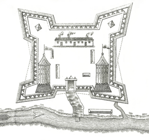
Five forts
Already an important pathway for the Iroquois Natives, the Richelieu river soon became one for French traders as well. French regime built five forts along its length: Fort Richelieu at its mouth, Fort St. Louis (or Fort Chambly) in Chambly, Fort Sainte Thérèse and Fort Saint-Jean upriver, and Fort Ste. Anne on the Isle La Motte, Vermont in Lake Champlain near its source.
In the 17th century, the repeated assaults of the Iroquois endanger the existence of the French colony of America. The first military posts, as Fort Richelieu in Sorel and the Fort Saint-Jean are built. The latter, built in 1666, led to the founding of the city of Saint-Jean, today Saint-Jean-sur-Richelieu. In the 18th century, the region was a strategic location increasingly coveted by the French and British colonial empires. The two powers wish to expand their territory and control the fur trade. Between 1819 and 1829, the British built Fort Lennox on an island of the Richelieu River, near the Canada-U.S. border, to prevent against possible attacks from Americans after the War of 1812. English and French built fortified posts larger, such as the Fort Lennox of Isle-aux-Noix, Fort Sainte Thérèse and Fort St. Louis (or Fort Chambly).
These fortifications and the fertile lands of the river will attract farmers. It was at this time that the region of Haut-Richelieu gets its nickname "Valley of the strongholds" (Vallée des forts).[18]
After 1759-1760, the period of the British conquest of New France, and after the War of Independence of the United States, the British military and loyal come to settle on the banks of the Richelieu. The battles of Saint-Denis and Saint-Charles occur along the Richelieu, during the 1837 French Canadian rebellion. In 1812, Americans borrowed the sea to invade their northern neighbor.
Economy
During the 19th century, the Richelieu became an important economic thoroughfare instead of a war path.[16] In 1843, construction of the Chambly Canal was completed, bypassing the rapids, allowing easier transportation of export products such as sawlogs, pulp, hay, and coal from Canada to the United States. Following this first channel, a network of channels are formed. These allow to join the Hudson River and then New York. International trade between Canada and the United States becomes possible.[19] Sorel and Saint-Jean-sur-Richelieu, which were both incorporated in the 1850s, arose as a direct result of the increased traffic on the Richelieu.[16]
Railroad development
By the end of the 19th century, however, railroads had largely replaced the river as commercial arteries. A tragic intersection of the two modes of transport occurred in 1864 when a train plunged off a swing bridge into the river after missing a red signal, killing 99 people.
Touristic industry
Tourists visit New York and Montreal through the River. Its contribution to regional prosperity is so crucial and, in the middle of the century, Saint-Jean turn to be the most important of Quebec and Canada inner harbor. The resort has largely replaced the business generated by the Richelieu considered a "heritage corridor".[20]
The river, which crosses densely populated areas as well as several agricultural land is an ecological challenge, especially down Basin Chambly. Measures concerning wastewater treatment reduced the presence of certain pollutants in recent years.
The Richelieu River caused extensive flooding during Spring 2011, damaging or destroying more than 3,000 homes in Quebec and at least 750 in Vermont.
Gallery of old images
-
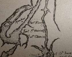
Map of Fort Saint-Jean and other forts on the Richelieu River circa 1666 for the campagne of the Regiment of Carignan-Salières
-
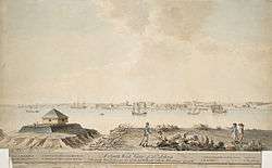
Fort Saint-Jean on Richelieu River in Canada during the 1750s
-
Fort Saint-Jean on Richelieu River in Canada during the 1750s
-
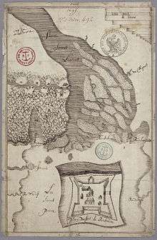
Fort Saint-Jean circa 1775 siege of the fort
-

Passage of the Richelieu by night
-

Fort Sainte-Thérèse on Richelieu River
Recreation
Although its commercial significance has waned, the Richelieu has remained an important recreational waterway. The Chambly Canal (9 locks) permits pleasure boats to bypass the rapids at Saint-Jean-sur-Richelieu and Chambly. The Champlain Canal and Lake Champlain form the U.S. portion of the Lakes to Locks Passage, linking with the Hudson River and allowing navigation using the Richelieu between the St. Lawrence River and New York City and the Erie Canal.
The Piste cyclable du Canal-de-Chambly is a 20 km (12 mi) bicycle path that follows the towpath along the canal. The bike path is part of Quebec's Route Verte bicycle path network. The canal is a national historic site operated by Parks Canada. The agency also manages other national historic sites along the river: Fort Chambly, Fort Ste. Thérèse, and St. Ours Canal.
Given the rich historical past of the region, the Richelieu River brings in its banks and its islands several sites, some of which are owned by Parks Canada National Historic Site Canal Chambly National Historic Site the Fort Lennox, the Fort Saint-Jean. As for the national historic site of Fort Chambly, it receives every year thousands of visitors during the 20Bière% 20and% 20Saveurs http://www.bieresetsaveurs.com/ celebrated the first days of September. In addition, the curious visitor to learn more about the history of the region could go to 20of% 20Top-Richelieu http://www.museeduhaut-richelieu.com/accueilmhr.html, Saint-Jean-sur-Richelieu.
Fishing
The Richelieu, which is home to more than 50 species of fish, offers excellent sport fishing opportunities.[21] Important sport species include northern pike, longnose gar, bowfin, smallmouth bass, largemouth bass, carp, and black crappie.[22] But the Richelieu also hosts several threatened or endangered species, such as the copper redhorse, river redhorse, and lake sturgeon, so fishing seasons and capture limits are regulated.[23]
Since agricultural products Montérégie enjoy an enviable reputation, many restaurateurs settle near the Richelieu River to combine fine dining and picturesque landscape. True country of maple and apple cider and sugar shacks abound in the area.
Hinterland
In urban and agricultural areas, there are mainly small mammals such as skunks, raccoon, squirrel and marmots.[24] Forest areas, which represent 16% of the land in the watershed,[25] host a variety of wildlife: there are among others American mink, deer, beaver, frogs[24] and several species of turtles including the softshell turtle, which is an endangered species[26] · .[27]
But the wildlife species most frequently sighted are birds. Because the river flows in a north-south axis, it is a migration corridor and one can observe several migrating birds. A staging area is located near Saint-Jean-sur-Richelieu, and depending on the time of year, birdswatchers can see various species of birds. For example, in the fall, visitors can see the arrival of thousands of geese and ducks.[24] One can also see the loggerhead shrike (an endangered species[28]), as well as the peregrine and golden eagle (classified as a vulnerable species[29] · [30]), and cerulean warblers, to name but a few.[31]
Regarding the flora, the catchment of the River belongs to the bioclimatic domain maple-hickory hickory.[32] It includes among others sugar maple and silver maple of hickory hickory of bur oak and oak bicolor of American elms and black ash, and several bushes and herbaceous[33] · .[34] Of these, several are considered vulnerable or endangered.[35] This is the case of the aplectrelle winter (Aplectrum hyemale),[36] the leek (Allium tricoccum)[37] and Canada lily (Lilium canadense).[38]
In the late 1990s, there was the presence of water chestnut at the mouth of the river. This invasive species threaten to stifle the fauna and flora, as it multiplies at lightning speed. The Ministry of Sustainable Development, Environment and Parks of Quebec struggle to get rid of, and indeed a breakout campaign began in 2001. Partners, such as CIME Haut-Richelieu has controlled the invasion of this plant in the harvesting.
Fish

The Richelieu River is home to more than fifty species of fish.[39] Many of them are considered threatened or endangered as copper redhorse, river redhorse and sturgeon. One of the last spawning of copper redhorse (Moxostoma hubbsi), a species endemic in Quebec is also found in the river. Other species, such as goby, are exogenous. In fact, they come from an external medium and were accidentally introduced into the ecosystem, often water discharge ballast vessels that ply the St. Lawrence River. Considered harmful or invasive, they colonize the water, funds and compete with native species (local) and a threat to the integrity of the ecosystem river.[40]
During the last decade, several methods have been implemented to protect endangered species. These projects include 2001, the fish ladder Vianney-Legendre which was built to help fish to pass the dam canal Saint-Ours. Named to honor the memory of Vianney-Legendre,[41] renowned ichthyologist, the structure of an innovative nature has been designed to accommodate different species of fish, especially those threatened.[42] This scale can even be used to raise awareness of the endangered species recovery. In 2002, the wildlife refuge Pierre-Étienne-Fortin (naturalist who first described the copper redhorse) was created to protect a breeding copper redhorse.[43] Access to the refuge is prohibited during the breeding season which runs from late June to late July.[44] Finally, every summer since 2006, as part of a patrol project established by the Committee for consultation and development of the basin of the River (COVABAR)[45] sensitizing agents plying the river in order to inform boaters the precarious situation of the copper redhorse and remind them regulations and measures in place to protect her[44] · .[46]
In addition, invasive species and increasing human presence are not only responsible for the fragility of some populations. According to a report from the Quebec Ministry of Sustainable Development, Environment and Parks (MDDEP) conducted in 1998,[47] the presence of pollutants and toxic agents in the waters of the river is also a "stressful" for fish. In several places in the river, a disturbing proportion of fish (over 13%) had abnormalities, which would signal a "precarious state of health" of the community ichthyological. However, the significant presence of fish-eating fish and some vulnerable species such as banded killifish, brought MDDEP to maintain the integrity index fish "average" (except in the Saint-Jean-sur-Richelieu, where he was considered "low"). Chub black chin, stonecat and lamprey East are also part of sentinel species in the watershed of the Richelieu River, like copper redhorse, whose presence is an indication of the quality of water and aquatic.[48] The data presented in the 1998 report are still used as a reference in 2011.[49]
The fragility of some ecosystems does not preclude the practice of sports and leisure activities. Some fish from the river can reach impressive and relevant to angling sizes. This activity is regulated, however : regular and sectoral restrictions and daily bag limits may apply between other sturgeons, the knights, millers and striped bass.[50]
References
- 1 2 3 de la Richelieu - Québec. Grandquebec.com (2007-01-15). Retrieved on 2013-07-12.
- 1 2 3 http://atlas.nrcan.gc.ca/site/english/learningresources/facts/rivers.html/#atlantic
- ↑ City of Saint-Jean-sur-Richelieu. " Rivière Richelieu characteristics of the river." Retrieved as of March 11, 2011.
- 1 2 The Consultative Committee and recovery of the watershed of the River (COVABAR) Basin. "Presentation of the territory". Retrieved on March 11, 2011.
- ↑ Atlas of Canada
- ↑ Match Richelieu-Charente / COVABAR. "The Richelieu River". Retrieved on March 11, 2011.
- ↑ Match-Charente, COVABAR. "The Richelieu River". Retrieved on March 11, 2011
- ↑ City of Saint-Jean-sur-Richelieu. "Rivière Richelieu Chambly Canal and multipurpose path". Retrieved on March 11, 2011.
- ↑ Parks Canada (Government of Canada). " National Historic Site of Fort Lennox". Retrieved on March 11, 2011.
- ↑ Sources: http://tourisme-megantic.com/bouger/riviere-chaudiere-90 http://aqt.phido.ca/index.php?p=167
- ↑ Jumelage Richelieu-Charente/COVABAR. « La rivière Richelieu » [archives]. Retrieved on March 28th 2012.
- ↑ Parks Canada / fra/lhn-nhs/qc/chambly/natcul/natcul1/natcul1b.aspx
- ↑ Parks Canada http://www.pc.gc.ca/fra/lhn-nhs/qc/saintours/natcul/natcul1.aspx # geology
- ↑ Grand Québec.com http://www.grandquebec.com/eaux-du-quebec/richelieu/
- ↑ http://www.bape.gouv.qc.ca/sections/mandats/Gaz_de_schiste/documents/DB14/Richelieu/DB14_EE_4Rapport.pdf
- 1 2 3 4 Rivière Richelieu - The Canadian Encyclopedia. Thecanadianencyclopedia.com. Retrieved on 2013-07-12.
- ↑ Greater Quebec http://grandquebec.com/eaux-du-quebec/histoire-richelieu/
- ↑ City of St-Jean-sur-Richelieu http://www.ville.saint-jean-sur-richelieu.qc.ca/cgi-bin/index.cgi? v0_8_1 page = & language=eng
- ↑ F. Chicoine, Parish of Saint-Charles-sur-Richelieu 1740-1980, Montreal, 1983, p.14.
- ↑ Biosphere Reserve of Mont Saint-Hilaire http://www.museevirtuel.ca/Exhibitions/Hilaire/html-fr/ index.php? page = culture_lieux_riviere.html
- ↑ Bassin versant de la rivière Richelieu. Mddep.gouv.qc.ca. Retrieved on 2013-07-12.
- ↑ guide de peche pour la riviere richelieu. Pecheurdurichelieu.forumactif.com (2008-12-21). Retrieved on 2013-07-12.
- ↑ Archived May 22, 2012, at the Wayback Machine.
- 1 2 3 Parcs Canada. "Lieu historique national du Canal de Chambly: La faune"
- ↑ COVABAR. "The Watershed"
- ↑ COVABAR 20PDE/Le % 20and % % % 20milieu 20biologique_resume.pdf "The biological environment: summary"
- ↑ Government of Québec, Natural Resources and wildlife. "Softshell Turtle"
- ↑ Quebec Government, Natural Resources and Wildlife. ? noEsp = 7 "Shrike"
- ↑ Government Quebec natural Resources and wildlife. "The Peregrine Falcon"
- ↑ Quebec Government, Natural Resources and wildlife. "the Golden Eagle"
- ↑ COVABAR. "List of threatened or vulnerable wildlife"
- ↑ Government of Quebec. Wildlife and natural resources. "vegetation zones and bioclimatic areas of Quebec"
- ↑ Parks Canada. "National Historic Site Chambly Canal: The flora"
- ↑ Government of Québec, Natural Resources and wildlife. "The exceptional forest ecosystems Montérégie: The MRC corridor of the Richelieu River and Montérégie".
- ↑ COVABAR. "List of plant species likely to be designated threatened or vulnerable"
- ↑ Government of Quebec. Sustainable Development, Environment and Parks. "Aplectrelle winter".
- ↑ Government of Quebec. Sustainable Development, Environment and Parks. "Leek"
- ↑ Government of Quebec. Sustainable Development, Environment and Parks. "Lilies of Canada"
- ↑ Ministry of Sustainable Development, Environment and Parks (Quebec). "The diversity of fish. The watershed of the River". Accessed March 7, 2011.
- ↑ N. St- Jacques, 1998, "The watershed of the Richelieu River: fish communities and the biotic integrity of the environment" in The catchment area of the River: the state of the aquatic ecosystem - 1995, Ministry of Environment and Wildlife (ed.), aquatic Ecosystems Branch, Quebec, Envirodoq no EN980604 report No. EA- 13, section 5.
- ↑ University of Montreal, the document management and archives. "Legendre Vianney 1917-1990"
- ↑ Parks Canada. "Endangered Species: Fish Ladder Vianney-Legendre"
- ↑ Government of Quebec, natural Resources and Wildlife. "Wildlife Refuge"
- 1 2 Fisheries and Oceans Canada. "In Quebec, a patrol project to restore the copper redhorse"
- ↑ COVABAR. "Understanding COVABAR"
- ↑ Vachon, Nathalie (Quebec Government, natural Resources and Wildlife). % 20Chevalier % 20cuivre.pdf "The history of copper redhorse described across three generations of mankind"
- ↑ Ministry of Sustainable Development, Environment and Parks (Quebec) / water / eco_aqua / oxford / h_riche.htm "State of the aquatic ecosystem of the watershed of the River - Summary 1998". Accessed March 7, 2011.
- ↑ Government of Quebec, sustainable Development, Environment and Parks."The diversity of fish catchment area of the River
- ↑ Government of Quebec, Sustainable Development, Environment and Parks. "State of the Aquatic Ecosystem - Watershed of the Richelieu River : Highlights 2005-2007"
- ↑ Ministry of Natural Resources and wildlife (Quebec) "fishing periods and catch limits - April 1, 2009 March 31, 2011". Accessed March 8, 2011.
See also
![]() Media related to Category: Richelieu River at Wikimedia Commons
Media related to Category: Richelieu River at Wikimedia Commons
- Champlain Lake
- Missisquoi Bay
- Missisquoi River
- Rivière-aux-Brochets Ecological Reserve
- Chambly Canal
- Ile aux Noix
- List of Quebec rivers
- List of crossings of the Richelieu River
- Lake Champlain Seaway
- 2011 Lake Champlain and Richelieu River Floods
Coordinates: 46°02′49″N 73°07′12″W / 46.04694°N 73.12000°W