Lower Wolfjaw Mountain
| Lower Wolfjaw Mountain | |
|---|---|
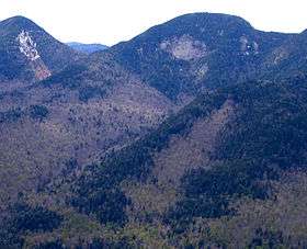 Lower Wolfjaw from Noonmark Mountain | |
| Highest point | |
| Elevation | 4,173 ft (1,272 m) [1] |
| Prominence | 663 ft (202 m) [1] |
| Listing | Adirondack High Peaks |
| Coordinates | 44°08′54″N 73°49′58″W / 44.1483845°N 73.8326399°WCoordinates: 44°08′54″N 73°49′58″W / 44.1483845°N 73.8326399°W [2] |
| Geography | |
| Location | Keene, Essex County, New York |
| Parent range | the Great Range |
| Topo map | USGS Keene Valley |
Lower Wolfjaw Mountain is located in Essex County, New York. Landscape artist Alexander Helwig Wyant (1836–1892) named Lower Wolfjaw, together with neighboring Upper Wolfjaw Mountain, about 1870 for their appearance in profile. The mountain is the northeasternmost of the Adirondack High Peaks in the Great Range of the Adirondack Mountains. Lower Wolfjaw Mountain is flanked to the southwest by Upper Wolfjaw Mountain, and to the northeast by Hedgehog Mountain.
Lower Wolfjaw Mountain stands within the watershed of the East Branch of the Ausable River, which drains into Lake Champlain, thence into Canada's Richelieu River, the Saint Lawrence River, and into the Gulf of Saint Lawrence. The east and southeast sides of Lower Wolfjaw Mtn. drain into Wedge Brook, thence into the East Branch of the Ausable River. The west side of Lower Wolfjaw Mountain drains into Wolfjaw Brook, thence into Johns Brook and the East Branch. The north side of Lower Wolfjaw drains into Bennies Brook, thence into Johns Brook. The northeast end of Lower Wolfjaw drains into Rock Cut Brook, thence into Johns Brook.
Lower Wolfjaw Mountain is within the High Peaks Wilderness Area of New York's Adirondack Park.
See also
- List of mountains in New York
- Northeast 111 4,000-footers
- Adirondack High Peaks
- Adirondack Forty-Sixers
References
- 1 2 "Lower Wolfjaw Mountain, New York". Peakbagger.com. Retrieved 2012-12-20.
- ↑ "Lower Wolfjaw Mountain". Geographic Names Information System. United States Geological Survey. Retrieved 2012-12-20.
External links
- "Lower Wolf Jaw Mountain". SummitPost.org.