Sault Ste. Marie International Bridge
| Sault Ste. Marie International Bridge | |
|---|---|
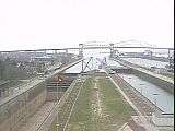
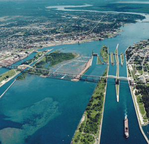 Aerial picture of the Sault Ste. Marie International Bridge and the Soo Locks | |
| Coordinates | 46°30′25″N 84°21′41″W / 46.50703°N 84.36132°WCoordinates: 46°30′25″N 84°21′41″W / 46.50703°N 84.36132°W |
| Carries |
Two lanes of traffic ( |
| Crosses | St. Marys River |
| Locale | Sault Ste. Marie, Michigan-Sault Ste. Marie, Ontario |
| Characteristics | |
| Design | truss arch bridge |
| Total length | 2.8 miles (4.5 km) |
| Width | 28 feet (8.5 m) |
| Longest span | 132 m |
| Clearance below | 124 feet (38 m) |
| History | |
| Opened | 1962 |
| Statistics | |
| Daily traffic | 7,000 vehicles daily (average), 10,000 vehicles daily (peak) |
| Toll | US$3.50, CAD$3.70,[1] |
The Sault Ste. Marie International Bridge spans the St. Marys River between the United States and Canada connecting the twin cities of Sault Ste. Marie, Michigan and Sault Ste. Marie, Ontario. It serves as the northern terminus of Interstate 75 (I-75). The International Bridge began construction in 1960 and officially opened to traffic on October 31, 1962.[2] Daily operation is carried on by the International Bridge Administration (IBA) under the supervision of the Sault Ste. Marie Bridge Authority (SSMBA). The SSMBA replaced the previous Joint International Bridge Authority (JIBA) in 2009, which in turn had succeeded the International Bridge Authority (IBA, created in 1935) in 2000.
This is a steel truss arch bridge with suspended deck. There are two separate spans, a double arch span on the U.S. side and a single arch span on the Canadian side. The double arch spans cross the four U.S. Soo Locks. The single arch spans the single Canadian Lock. In Sault Ste. Marie, Ontario, the bridge ends at a city street, Huron Street, in the downtown core. The total length of the bridge approaches 2.8 miles (4.5 km). The Bridge allows bicycles to cross, but the lack of dedicated bike lanes requires cyclists to take proper precautions to ensure visibility.[3]
The International Bridge Bus crosses the Bridge hourly from 7:00 am - 7:00 pm on weekdays and 9:00 am - 4:00 pm on Saturdays, serving both downtown areas and Lake Superior State University[4] on the Michigan side and the Station Mall on the Ontario side.[5]
A tourist information radio station, CIRS, broadcast at 530 AM from the Ontario side of the bridge until 2010.
History

In 1954 the state of Michigan created the International Bridge Authority.[6] Canada followed in 1955, creating the St.Mary's River Co.[6]
Beginning in 1987, an annual International Bridge Walk has been held on the last Saturday in June, starting on the Michigan side, with participants finishing in Ontario.
On June 6, 2005, the Ontario government announced a construction project to build a dedicated truck bypass route to connect the bridge to Highway 17 in the north end of the city. The city had lobbied for this for some time, since the bridge's terminus at a city street was viewed by many residents of the city as a safety concern; however, the bridge terminus itself cannot be easily relocated due to the already highly urbanized nature of the Sault, Ontario waterfront. The truck route, known as Carmen's Way in memory of the city's former federal MP Carmen Provenzano, was officially opened in September 2006.
Construction work subsequently commenced in 2009 on a project to expand and modernize the Canadian bridge plaza, including a larger Canada Border Services Agency building with improved truck inspection facilities and a dedicated route to take trucks directly to Carmen's Way, thereby eliminating the need for trucking traffic to enter Huron Street.[7]
Beginning in May 2014, construction work commenced on improvements to the plaza on the Michigan side of the bridge.[8]
See also
-
 Bridges portal
 -
 Michigan portal
 -
 Ontario portal
References
- ↑ "Information Bulletin" (PDF). State of Michigan. April 1, 2014. Retrieved August 12, 2014.
- ↑ Staff (September 12, 2008). "Bridge Facts & Trivia". Michigan Department of Transportation. Retrieved September 5, 2010.
- ↑ "Biking on Major Bridges". Michigan Department of Transportation. 2016. Retrieved March 24, 2016.
- ↑ "Simplify travel between the Twin Saults". Lake Superior State University. Retrieved March 24, 2016.
- ↑ "Sault International Bridge Bus". Community Action Agency Human Resource Authority. Retrieved March 24, 2016.
- 1 2 Staff (1963). The International Bridge. S.I.: International Bridge Authority of Michigan.
- ↑ Ross, Ian (September 4, 2009). "Expansion of Sault bridge plaza begins this fall". Northern Ontario Business. Retrieved April 18, 2012.
- ↑ "Michigan Soo breaks ground on toll plaza". Northern Ontario Business, May 16, 2014.
External links
| Wikimedia Commons has media related to Sault Ste. Marie International Bridge. |
- International Bridge
- International Bridge Photos
- Announcement of truck route construction by the Ontario Ministry of Public Infrastructure Renewal
- International Bridge Web Cams
- Sault Ste. Marie International Bridge at Structurae
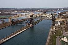
 Looking west towards the International Bridge from the American Locks administration building
 International Bridge, from south Whitefish Island
| Central cities | |
|---|---|
| Counties | |
| Geography | |
| Transportation | |
| Economy | |