Marquette, Michigan
| Marquette, Michigan | |
|---|---|
| City | |
|
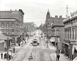
Front Street in downtown Marquette, 1909 | |
 Location of Marquette within Marquette County, Michigan | |
 Marquette, Michigan Location in the United States | |
| Coordinates: 46°32′47″N 87°24′24″W / 46.54639°N 87.40667°WCoordinates: 46°32′47″N 87°24′24″W / 46.54639°N 87.40667°W | |
| Country | United States |
| State | Michigan |
| County | Marquette |
| Government | |
| • Type | Commission-Manager |
| • Mayor | Dave Campana[1] |
| • City Manager | L. Michael Angeli[2] |
| Area[3] | |
| • City | 19.45 sq mi (50.38 km2) |
| • Land | 11.39 sq mi (29.50 km2) |
| • Water | 8.06 sq mi (20.88 km2) |
| Elevation | 633[4] ft (203 m) |
| Population (2010)[5] | |
| • City | 21,355 |
| • Estimate (2012[6]) | 21,532 |
| • Density | 1,874.9/sq mi (723.9/km2) |
| • Metro | 67,077 |
| Time zone | EST (UTC-5) |
| • Summer (DST) | EDT (UTC-4) |
| ZIP code | 49855 |
| Area code(s) | 906 |
| FIPS code | 26-51900[5] |
| GNIS feature ID | 0631600[7] |
| Website |
www |
Marquette is a city in the U.S. state of Michigan and the county seat of Marquette County.[8] The population was 21,355 at the 2010 census, making it the most populated city of the Upper Peninsula. Marquette is a major port on Lake Superior, known primarily for shipping iron ore, and is the home of Northern Michigan University. In 2012, Marquette was listed among the 10 best places to retire in the U.S. by CBS Money Watch.[9]
History
The land around Marquette was known to French missionaries of the early 17th century and the trappers of the early 19th century. A mission was established at what became Marquette in 1675. Development of the area did not begin, however, until 1844, when William Burt and Jacob Houghton (the brother of geologist Douglass Houghton) discovered iron deposits near Teal Lake west of Marquette. In 1845, Jackson Mining Company, the first organized mining company in the region, was formed.[10]
The village of Marquette began on September 14, 1849, with the formation of a second iron concern, the Marquette Iron Company. Three men participated in organizing the firm: Robert J. Graveraet, who had prospected the region for ore; Edward Clark, agent for Waterman A. Fisher of Worcester, Massachusetts, who financed the company, and Amos Rogers Harlow. The village was at first called New Worcester, with Harlow as the first postmaster. On August 21, 1850, the name was changed to honor Jacques Marquette, the French Jesuit missionary who had explored the region. A second post office, named Carp River, was opened on October 13, 1851 by Peter White, who had gone there with Graveraet at age 18.[11] Harlow closed his post office in August 1852. The Marquette Iron Company failed, while its successor, the Cleveland Iron Mining Company, flourished and had the village platted in 1854. The plat was recorded by Peter White. White's office was renamed as Marquette in April 1856, and the village was incorporated in 1859. It was incorporated as a city in 1871.[12]
During the 1850s, Marquette was linked by rail to numerous mines and became the leading shipping center of the Upper Peninsula. The first ore pocket dock, designed by an early town leader, John Burt, was built by the Cleveland Iron Mining Company in 1859.[13] By 1862, the city had a population of over 1,600 and a soaring economy.[10]
In the late 19th century, during the height of iron mining, Marquette became nationally known as a summer haven. Visitors brought in by Great Lakes passenger steamships filled the city's hotels and resorts.[13]
South of the city, K. I. Sawyer Air Force Base was an important Air Force installation during the Cold War, host to B-52H bombers and KC-135 tankers of the Strategic Air Command, as well as a fighter interceptor squadron. The base closed in September 1995, and is now the county's Sawyer International Airport.
Marquette continues to be a shipping port for hematite ores and, today, enriched iron ore pellets, from nearby mines and pelletizing plants. About 7.9 million gross tons of pelletized iron ore passed through Marquette's Presque Isle Harbor in 2005.[13]
The Roman Catholic Bishop Frederic Baraga is buried at St. Peter's Cathedral, which is the center for the Diocese of Marquette.
Postal and philatelic history
In addition to the Marquette #1 Post Office there is the "Northern Michigan University Bookstore Contract Station #384".[14]
The first day of issue of a postal card showing Bishop Frederic Baraga took place in Marquette on June 29, 1984, and that of the Wonders of America Lake Superior stamp[15] on May 27, 2006.[16]
Geography and climate
Geography
According to the United States Census Bureau, the city has a total area of 19.45 square miles (50.38 km2), of which 11.39 square miles (29.50 km2) is land and 8.06 square miles (20.88 km2) is water.[3]
The city includes several small islands (principally Middle Island, Gull Island, Lover's Island, Presque Isle Pt. Rocks, White Rocks, Ripley Rock, and Picnic Rocks) in Lake Superior. The Marquette Underwater Preserve lies immediately offshore.
Marquette Mountain, used for skiing, is located in the city, as is most of the land of Marquette Branch Prison of the Michigan Department of Corrections.[17] Trowbridge Park (an unincorporated part of Marquette Township) is located to the west, and Marquette Township to the northwest of the city.
Suburbs
Climate
Marquette has a humid continental climate (Köppen climate classification Dfb) with four distinct seasons that is strongly moderated by Lake Superior and is located in Plant Hardiness zone 5b.[18] Winters are long and cold with a January average of 18.8 °F (−7.3 °C). Winter temperatures are slightly warmer than inland locations at a similar latitude due to the release of the heat stored by the lake, which moderates the climate.[19] On average, there are 11.6 days where the temperature reaches below 0 °F (−18 °C) and most days during winter remain below freezing.[20] Being located in the snowbelt region, Marquette receives a significant amount of snowfall during the winter months, mostly from lake-effect snow. Because Lake Superior rarely freezes over completely, this enables lake effect snow to persist throughout winter, making Marquette the third snowiest location in the contiguous United States as reported by the National Oceanic and Atmospheric Administration with an average annual snowfall of 149.1 inches (379 cm).[21] The snow depth in winter usually exceeds 10 inches (25 cm).[20]
The warmest months, July and August, each average 66.6 °F (19.2 °C), showing somewhat of a seasonal lag. The surrounding lake cools summertime temperatures[19] and as a result, temperatures above 90 °F (32 °C) are rare, with only 3.4 days per year.[20] Spring and fall are transitional seasons that are generally mild though highly variable due to the alternation of air masses moving quickly. Spring is usually cooler than fall because the surrounding lake is slow to warm than the land while in fall, the lake releases heat, warming the area.[19]
Marquette receives 29 in (737 mm) of precipitation per year, which is fairly evenly distributed throughout the year, though September and October are the wettest months with January and February being the driest. The average window for nighttime freezes is October 15 thru May 7.[20] The highest temperature ever recorded in Marquette was 108 °F (42 °C) on July 15, 1901 and the lowest was −33 °F (−36 °C) on February 8, 1861.[20] Marquette receives an average of 2,294 hours of sunshine per year or 51% of possible sunshine, ranging from a low of 29% in December to a high of 68% in July.[22]
| Climate data for Marquette, Michigan | |||||||||||||
|---|---|---|---|---|---|---|---|---|---|---|---|---|---|
| Month | Jan | Feb | Mar | Apr | May | Jun | Jul | Aug | Sep | Oct | Nov | Dec | Year |
| Record high °F (°C) | 57 (14) |
69 (21) |
82 (28) |
91 (33) |
100 (38) |
101 (38) |
108 (42) |
102 (39) |
98 (37) |
89 (32) |
74 (23) |
60 (16) |
108 (42) |
| Average high °F (°C) | 25.0 (−3.9) |
27.8 (−2.3) |
35.9 (2.2) |
47.3 (8.5) |
59.4 (15.2) |
68.3 (20.2) |
74.5 (23.6) |
74.2 (23.4) |
66.8 (19.3) |
53.9 (12.2) |
40.3 (4.6) |
29.1 (−1.6) |
50.2 (10.1) |
| Daily mean °F (°C) | 13.6 (−10.2) |
15.5 (−9.2) |
24.2 (−4.3) |
37.9 (3.3) |
50.9 (10.5) |
60.6 (15.9) |
65.5 (18.6) |
63.7 (17.6) |
55.8 (13.2) |
43.2 (6.2) |
30.3 (−0.9) |
18.5 (−7.5) |
40.0 (4.4) |
| Average low °F (°C) | 12.5 (−10.8) |
13.6 (−10.2) |
22.1 (−5.5) |
32.9 (0.5) |
42.6 (5.9) |
51.5 (10.8) |
58.6 (14.8) |
59.0 (15) |
52.0 (11.1) |
40.6 (4.8) |
29.3 (−1.5) |
18.0 (−7.8) |
36.1 (2.3) |
| Record low °F (°C) | −26 (−32) |
−33 (−36) |
−19 (−28) |
3 (−16) |
16 (−9) |
29 (−2) |
36 (2) |
33 (1) |
22 (−6) |
12 (−11) |
−9 (−23) |
−20 (−29) |
−33 (−36) |
| Average precipitation inches (mm) | 1.80 (45.7) |
1.31 (33.3) |
2.01 (51.1) |
2.33 (59.2) |
2.56 (65) |
2.67 (67.8) |
2.66 (67.6) |
2.63 (66.8) |
3.31 (84.1) |
3.14 (79.8) |
2.63 (66.8) |
1.95 (49.5) |
28.98 (736.1) |
| Average snowfall inches (cm) | 32.0 (81.3) |
26.6 (67.6) |
24.6 (62.5) |
10.5 (26.7) |
1.5 (3.8) |
0 (0) |
0 (0) |
0 (0) |
0.2 (0.5) |
4.3 (10.9) |
18.3 (46.5) |
31.7 (80.5) |
149.1 (378.7) |
| Average precipitation days (≥ 0.01 in) | 17.3 | 11.4 | 11.9 | 10.5 | 10.3 | 11.4 | 10.8 | 10.8 | 13.1 | 13.8 | 13.6 | 15.0 | 150.0 |
| Average snowy days (≥ 0.1 in) | 18.6 | 12.3 | 10.1 | 4.4 | 0.2 | 0 | 0 | 0 | 0.1 | 0.8 | 7.7 | 14.7 | 68.8 |
| Mean monthly sunshine hours | 105.5 | 128.8 | 181.3 | 225.3 | 278.8 | 289.7 | 322.8 | 270.6 | 191.5 | 140.6 | 80.7 | 78.2 | 2,293.8 |
| Source: NOAA (normals 1981–2010, sun 1961–1990, extremes 1860–present)[20][21][22] | |||||||||||||
Demographics
| Historical population | |||
|---|---|---|---|
| Census | Pop. | %± | |
| 1850 | 136 | — | |
| 1870 | 4,000 | — | |
| 1880 | 4,690 | 17.3% | |
| 1890 | 9,098 | 94.0% | |
| 1900 | 10,058 | 10.6% | |
| 1910 | 11,503 | 14.4% | |
| 1920 | 12,718 | 10.6% | |
| 1930 | 14,789 | 16.3% | |
| 1940 | 15,928 | 7.7% | |
| 1950 | 17,202 | 8.0% | |
| 1960 | 19,824 | 15.2% | |
| 1970 | 21,967 | 10.8% | |
| 1980 | 23,288 | 6.0% | |
| 1990 | 21,977 | −5.6% | |
| 2000 | 19,661 | −10.5% | |
| 2010 | 21,355 | 8.6% | |
| Est. 2015 | 21,297 | [23] | −0.3% |
| U.S. Decennial Census 2012 estimate | |||
2010 census
As of the census[24] of 2010, there were 21,355 people, 8,321 households, and 3,788 families residing in the city. The population density was 1,874.9 inhabitants per square mile (723.9/km2). There were 8,756 housing units at an average density of 768.7 per square mile (296.8/km2). The racial makeup of the city was 91.1% White, 4.4% African American, 1.5% Native American, 0.9% Asian, 0.3% from other races, and 1.8% from two or more races. Hispanic or Latino of any race were 1.4% of the population.
There were 8,321 households of which 18.6% had children under the age of 18 living with them, 33.3% were married couples living together, 9.0% had a female householder with no husband present, 3.3% had a male householder with no wife present, and 54.5% were non-families. 38.2% of all households were made up of individuals and 11.8% had someone living alone who was 65 years of age or older. The average household size was 2.05 and the average family size was 2.71.
The median age in the city was 29.1 years. 12.2% of residents were under the age of 18; 30.6% were between the ages of 18 and 24; 22.3% were from 25 to 44; 21.9% were from 45 to 64; and 13% were 65 years of age or older. The gender makeup of the city was 51.8% male and 48.2% female.
2000 census
At the 2000 census,[5] there were 19,661 people, 8,071 households and 4,067 families residing in the city. The population density was 1,723.9 per square mile (665.3/km²). There were 8,429 housing units at an average density of 739.1 per square mile (285.4/km2). The racial makeup of the city was 95% White, 0.8% African American, 1.7% Native American, 0.8% Asian, 0% Pacific Islander, 0.22% from other races, and 1.33% from two or more races. Hispanic or Latino of any race were 0.77% of the population. 15.5% were of German, 12.6% Finnish, 8.9% French, 8.5% English, 8.2% Irish, 6.8% Italian and 6.7% Swedish ancestry according to Census 2000.
There were 8,071 households of which 23.0% had children under the age of 18 living with them, 37.2% were married couples living together, 10.2% had a female householder with no husband present, and 49.6% were non-families. 37.0% of all households were made up of individuals and 11.5% had someone living alone who was 65 years of age or older. The average household size was 2.13 and the average family size was 2.81.
Age distribution was 16.8% under the age of 18, 25.9% from 18 to 24, 23.8% from 25 to 44, 19.7% from 45 to 64, and 13.8% who were 65 years of age or older. The median age was 31 years. For every 100 females there were 94.4 males. For every 100 females age 18 and over, there were 92.4 males.
The median household income was $29,918, and the median family income was $48,120. Males had a median income of $34,107 versus $24,549 for females. The per capita income for the city was $17,787. About 7.2% of families and 17.0% of the population were below the poverty line, including 12.3% of those under age 18 and 5.1% of those age 65 or over.
Business
Along with Northern Michigan University, the largest employers in Marquette are the Marquette School System, Marquette General Hospital (a regional medical center which is the only Level 2 Trauma center in the Upper Peninsula), Marquette Branch Prison, Pioneer Surgical Technology now part of RTI Surgical, and Charter Communications.
Marquette's port was the 140th largest in the United States in 2015, ranked by tonnage.[25]
Recreation and tourism
Recreational facilities

The city of Marquette has a number of parks and recreational facilities which are used by city and county residents. Presque Isle Park is Marquette's most popular park located on the north side of the city. It includes 323 acres (131 ha) of mostly forested land and juts out into Lake Superior. The park was designed by Frederick Law Olmsted, noted for designing Central Park in New York City. Amenities include a wooden band shell for concerts, a park pavilion, a gazebo, a marina, a concession stand, picnic tables, barbecue pits, walking/skiing trails, playground facilities, and Moosewood Nature Center. The city has two popular beaches, South Beach Park and McCarty's Cove. McCarty's Cove, flanked by the red U.S. Coast Guard Station lighthouse on its south shore, serves as a reprieve from hot summer days, where city and county residents alike take advantage of the cool, but tolerable, water temperatures and the cooling effects of the lake-generated sea breeze. Both beaches have picnic areas, grills, children's playgrounds and lifeguard stands. Other parks include Tourist Park, Founder's Landing, LaBonte Park, Mattson Lower Harbor Park, Park Cemetery, Shiras Park, Williams Park, Harlow Park, Pocket Park, Spring Street Park and Father Marquette Park.

There are also numerous other recreational facilities located within the city. Lakeview Arena is best known for its use as an ice hockey facility, but it also hosts a number of public events. A skateboard park is located just outside the arena and open during the summer. Lakeview Arena was home to the Marquette Electricians and Marquette Senior High School's Redmen hockey team. In 1974, the arena replaced the historic Palestra, which had been located a few blocks away. Gerard Haley Memorial Baseball field home of the Marquette Blues and Reds is located in the north side along with numerous little league and softball fields. Marquette has the largest wooden dome in the world, the Superior Dome—unofficially but affectionately known as the YooperDome. During the football season, the Dome is used primarily for football on its newly renovated astro turf field. The turf was installed in July 2009. Northern Michigan University holds its home football games in the Dome, as does the Michigan High School Athletic Association with the upper peninsula's High School football playoffs. The dome also hosts numerous private and public events which draw in thousands from around the region. The Marquette Golf Club has brought international recognition to the area for its unique and dramatic Greywalls course, opened in 2005. The course features several panoramic views of Lake Superior and winds its way through rocky outcroppings, heaving fairways and a rolling valley, yet is located less than two miles (3 km) from the downtown area.
The city is also known for fishing for deep water lake trout, whitefish, salmon and brown trout.
Marquette has an extensive network of biking and walking paths. The city has been gradually expanding the paths and has been promoting itself as a walkable and livable community. Cross Country ski trails are also located at Presque Isle Park and the Fit Strip.[26]
Camping facilities are located at Tourist Park.
The combination of hilly terrain (a 600-foot (180 m) vertical difference from top to bottom) and large area snow falls makes snowboarding and downhill skiing a reality on the edge of town.[27]
Museums, galleries, and lighthouses
- The Marquette Maritime Museum, including the Marquette Harbor Light;[28]
- The Upper Peninsula Children's Museum, Baraga Avenue.[29]
- The Marquette County History Museum.[30]
- The DeVos Art Museum, Northern Michigan University.[31]
- The Oasis Gallery for Contemporary Art.[32]
Festivals and events
- Art on the Rocks—art festival at Ellwood Mattson Lower Harbor Park
- Hiawatha Music Festival Traditional music festival at Tourist Park
- Marquette's July 4 Celebration[33]
- Marquette's Blueberry Festival [34]
- Superior Bike Fest[35]
- UP 200 Dog Sled Race[36]
- Noquemanon Ski Marathon[37]
- Marquette Area Blues Fest[38]
- Marquette Scandinavian Midsummer Festival and Wife-Carrying Contest[39]
- U.P. Fall Beer Festival- hosted by Michigan Brewers Guild [40]
- Ore to Shore[41]
- Marquette Marathon[42]
- OutBack Art Fair[43]
Live theatrical productions are also provided through Northern Michigan University's Forest Roberts Theatre and Black Box Theatre, Marquette's Graverate School Kaufman Auditorium and Lake Superior Theatre, a semi-professional summer stock theatre.
Transportation

Marquette is served by American Eagle and Delta Air Lines out of Sawyer International Airport with daily flights to Chicago and Detroit.
Marquette is served by a transportation bus system called the "MarqTran" that runs through the city and to nearby places such as Sawyer International Airport and Ishpeming. Indian Trails bus lines operates daily intercity bus service between Hancock and Milwaukee, Wisconsin, with a stop in Marquette.[44]
Marquette has limited freight rail service by the Lake Superior and Ishpeming Railroad. The Canadian National Railway also goes through nearby Negaunee.
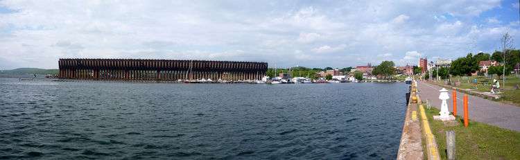
Marquette's Presque Isle, or Upper, Harbor Ore Dock loads iron ore pellets onto ships.[45]
Highways
-
 US 41 is a major highway continuing westerly and northerly toward Houghton and southerly toward Escanaba.
 -
 M-28 travels westerly to Wakefield and easterly toward Sault Ste. Marie.
 -
 M-553 provides a direct connection to Sawyer International Airport.
Education
Public schools
The City of Marquette is served by the Marquette Area Public Schools. The district is the largest school district in the Upper Peninsula and Northern Wisconsin, with about 3,100 students and 420 Faculty and Staff.
- Marquette Senior High School, Grades 9-12 (Marquette Area Public Schools)
- Marquette Alternative High School at Vandenboom (Marquette Area Public Schools)[46]
- Bothwell Middle School, Grades 6-8 (Marquette Area Public Schools)[47]
- Cherry Creek Elementary (Marquette Area Public Schools)
- Graveraet Elementary (Marquette Area Public Schools)[48]
- Sandy Knoll Elementary School (Marquette Area Public Schools)
- Superior Hills Elementary School (Marquette Area Public Schools)
- North Star Academy (Public Charter School)
Private schools
Universities
- Marquette is home to Northern Michigan University, the Upper Peninsula's largest university at just under 10,000 students.
Public libraries
Media
Multiple media outlets provide local coverage of the Marquette area.
- Newspaper: The Mining Journal, The North Wind, and Marquette Monthly
- Television: WLUC-TV/WLUC-DT2, WBUP-TV/WBKP, WZMQ, WNMU-TV and WJMN-TV
- Radio: WNMU-FM, WHWL-FM, WUPK-FM, WFXD-FM, WUPT-FM, WUPX, WJPD-FM, WUPZ-FM, WKPK-FM, WUPG-FM, WGLQ-FM, WRUP-FM, WNGE-FM, WKQS-FM, WCMM-FM, W291BH, WMQT, WDMJ-AM, WIAN-AM and WZAM-AM
Accolades and awards
- 2010 Distinctive Destination—National Trust of Historic Preservation (Voted #1 Fan Favorite)[50]
- 2008 Top 10 Winter Family Getaways—The Weather Channel
- 2008 #7 Best Place to Live for Hunters and Anglers—Outdoor Life Magazine
- 2008 #7 in Mid-West in Rural America—Progressive Farmer
- 2005, 2007, 2008 One of the 100 Best Communities for Young People—America's Promise: Alliance for Youth
- 2006 #7 Place to Build a Vacation Home—Men's Journal
- 2005 Top 10 Summer Vacation Destination—Sherman Travel
- 2004 Most Livable Community—Partners for Livable Communities
- 2004 Michigan Cool City—Governor Jennifer Granholm
- 2003 All America County—National Civic League
- Tree City for 30 Years
- Top micropolitan area—Site Selection Magazine
Notable people
- Stephen Adamini, politician
- Mike Bordick, baseball player
- Edward Breitung, minister
- Leonard Brumm, college hockey coach
- Alfred Burt, composer of Christmas carols
- Kyle Carr, speed skater
- Curtis L. Carter, academic and founder of the Patrick and Beatrice Haggerty Museum of Art
- Tony Chebatoris, the only person executed in Michigan since 1846
- Sallie W. Chisholm, oceanographer
- Robert William Davis, politician
- Shani Davis, speed skater
- Susan Diol, actress
- Dallas Drake, NHL player
- Nita Engle, artist
- Robert Erickson, composer
- Joe Fine, mayor of Marquette 1964–1965 and prominent businessman
- Justin Florek, NHL player
- Vernon Forrest, boxer
- James Henry Garland, Catholic bishop
- John Gilmore, NFL tight end
- Patricia Hogan, professor
- John Henry Jacobs, former mayor
- Alfred V. Kidder, archaeologist
- Reynolds R. Kinkade, justice of the Ohio Supreme Court
- John Kivela, former mayor
- John Munro Longyear, former mayor and land developer
- Mary Beecher Longyear, philanthropist
- John Lautner, architect
- John D. Magnum, politician
- Francis Joseph Magner, Catholic bishop
- Aghasi Manukyan, wrestler
- Helen Maroulis, wrestler
- Beverly Matherne, writer
- C. V. Money, coach
- Ignatius Mrak, bishop of the Roman Catholic Diocese of Marquette
- William J. Olcott, mining executive and college football player
- David Palumbo, illustrator
- Jimmy Peters, Sr., NHL hockey player
- Hjalmar Peterson, musician and comedian
- Joseph G. Pinten, Catholic bishop
- Jeremy Porter, rock musician
- Robert Roosa, economist
- Chris Rothfuss, Wyoming politician
- Ralph Royce, USAF general
- Mark Francis Schmitt, Catholic bishop
- Bernard F. Sliger, former president, Florida State University
- Sycamore Smith, folk musician
- Matthew Songer, surgeon
- Frederic Dorr Steele, illustrator
- Mary Stein, actress
- Wendel Suckow, luger
- Jane Summersett, ice dancer
- Alfred P. Swineford, former mayor and newspaper editor
- John Vertin, Catholic bishop
- Peter White, businessman
In popular culture
- Robert Traver (John Voelker) set his novels Anatomy of a Murder (1958) and Laughing Whitefish (1965) in Marquette. The film version of Anatomy of a Murder, dramatizing a 1952 murder that happened in the area and the subsequent trial, was partly filmed in Marquette and Big Bay. Much of it was filmed in the Marquette County Courthouse in Marquette, where the actual murder case had been tried. Traver's Danny and the Boys (1951) is a collection of short stories set in and around Marquette.
- Philip Caputo set his novel Indian Country (1987) in the Upper Peninsula and several scenes depict Marquette.
- Jim Harrison's novel True North (2005) tells about a Marquette family whose wealth is based on exploiting Upper Peninsula timber.
- Jeffrey Eugenides' Pulitzer Prize winning novel, Middlesex (2002) refers to Marquette by name, in addition to other locations in Michigan.
- A large portion of the graphic novel Blankets, by Craig Thompson, takes place in Marquette.
Sister cities
Marquette has two sister cities.[51]
 Higashiōmi (Japan) since 1979
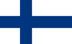 Kajaani (Finland) 1997
See also
References
- ↑ "Meet Your Commissioners". City of Marquette. Retrieved December 9, 2014.
- ↑ Jarvi, Ryan (September 15, 2015). "Angeli given manager's position". The Mining Journal. Marquette, MI. Retrieved September 22, 2015.
- 1 2 "US Gazetteer files 2010". United States Census Bureau. Retrieved November 25, 2012.
- ↑ "NOAA National Weather Service".
- 1 2 3 "American FactFinder". United States Census Bureau. Retrieved January 31, 2008.
- ↑ "Population Estimates". United States Census Bureau. Retrieved June 3, 2013.
- ↑ U.S. Geological Survey Geographic Names Information System: Marquette, Michigan
- ↑ "Find a County". National Association of Counties. Retrieved June 7, 2011.
- ↑ Smith, Nancy F. (March 8, 2012). "The 10 Best Places to Retire". Yahoo! Finance. Retrieved February 3, 2013.
- 1 2 Eckert, Kathryn Bishop (2000). The Sandstone Architecture of the Lake Superior Region. Detroit: Wayne State University Press. pp. 89–91. ISBN 0-8143-2807-5.
- ↑ "[not listed]". Inland Seas. 1968 – via Google Books.
- ↑ Romig, Walter (1986) [1973]. Michigan Place Names. Detroit: Wayne State University Press. ISBN 0-8143-1838-X.
- 1 2 3 Bogue, Margaret Beattie (2007). Around the Shores of Lake Superior: A Guide to Historic Sites. Madison: University of Wisconsin Press. pp. 237–39. ISBN 0-299-22174-1.
- ↑ "Post Office Photo Collection". Post Mark Collectors Club.
- ↑ "39c Lake Superior single". Arago.com. Retrieved April 23, 2013.
- ↑ "Dedication of Wonders of America Lake Superior Stamp". Marquette Maritime Museum. Archived from the original on May 20, 2012.
- ↑ "Marquette Branch Prison". Michigan Department of Corrections.
- ↑ USDA Plant Hardiness Zone Map (Map). United States Department of Agriculture. Retrieved May 10, 2013.
- 1 2 3 "Natural Processes in the Great Lakes". The Great Lakes An Environmental Atlas and Resource Book. Environmental Protection Agency. Retrieved May 10, 2013.
- 1 2 3 4 5 6 "NOWData: NOAA Online Weather Data". National Oceanic and Atmospheric Administration. Retrieved May 9, 2013.
- 1 2 "Comparative Climate Data For the United States Through 2012" (PDF). National Oceanic and Atmospheric Administration. p. 56. Archived from the original (PDF) on July 18, 2014. Retrieved December 6, 2014.
- 1 2 "Marquette/FAA ARPT MI Climate Normals 1961–1990". National Oceanic and Atmospheric Administration. Retrieved May 9, 2013.
- ↑ "Annual Estimates of the Resident Population for Incorporated Places: April 1, 2010 to July 1, 2015". Retrieved July 2, 2016.
- ↑ "American FactFinder". United States Census Bureau. Retrieved November 25, 2012.
- ↑ "Principal Ports of the United States". U.S. Army Corps of Engineers. October 12, 2016. Retrieved December 2, 2016.
- ↑ "Presque Isle State Park: Winter Activities". Archived from the original on July 24, 2008.
- ↑ "Marquette Mountain Ski Resort".
- ↑ "Marquette Maritime Museum and Lighthouse". Retrieved March 19, 2015.
- ↑ "Upper Peninsula Children's Museum". Upper Peninsula Children's Museum.
- ↑ "About Us". Marquette County History Museum.
- ↑ "DeVos Art Museum". Northern Michigan University.
- ↑ "About Us". Oasis Gallery for Contemporary Art. Archived from the original on June 2, 2002.
- ↑ "Marquette area 4th of July committee".
- ↑ "Blueberry Festival".
- ↑ "Superior Bike Fest".
- ↑ "The UP-200".
- ↑ "Noquemanon Ski Marathon".
- ↑ "Marquette Area Blues Fest". Marquette Area Blues Fest Society.
- ↑ Cheatham, Sierra, ed. (June 2007). "City Notes". Marquette Monthly. Archived from the original on October 13, 2008. Retrieved February 3, 2013.
- ↑ "U.P. Fall Beer Festival". Michigan' Brewers Guild.
- ↑ "Ore 2 Shore". Ore 2 Shore.
- ↑ "Marquette Marathon and Half Marathon". Marquette Marathon.
- ↑ "Home Page". Out Back Art Fair.
- ↑ "Hancock–Marquette–Green Bay–Milwaukee" (PDF). Indian Trails. January 12, 2012. Retrieved February 27, 2013.
- ↑ "Marquette ore docks a reminder of the city's maritime and mining heritage". Michigan Radio. September 1, 2015. Retrieved July 16, 2016.
- ↑ "Marquette Alternative High School at Vandenboom". Marquette Area Public Schools.
- ↑ "Fifth-Graders to Move to Bothwell". The Mining Journal. Marquette, MI. February 24, 2010. Retrieved February 3, 2013.
- ↑ "Graveraet Elementary". Marquette Area Public Schools.
- 1 2 "Father Marquette Catholic School". Father Marquette Elementary School.
- ↑ "National Trust for Historic Preservation Announces that Marquette, Mich. Is 'Fan Favorite' Among 2010 Dozen Distinctive Destination" (Press release). National Trust of Historic Preservation. March 1, 2010. Archived from the original on April 13, 2010.
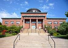
- ↑ Hunt, Mary; Hunt, Don (2007). "Peter White Library". Hunts' Guide to Michigan's Upper Peninsula. Albion, MI: Midwestern Guides. Retrieved February 3, 2013.
- Harrison, Jim (November 30, 2013). "Imprint: My Upper Peninsula". The New York Times. Retrieved November 30, 2013.
External links
| Wikimedia Commons has media related to Marquette, Michigan. |
-
 Marquette, Michigan travel guide from Wikivoyage
 - City of Marquette
- National Weather Service WFO Marquette, Michigan
- Marquette, Michigan at DMOZ
Municipalities and communities of Marquette County, Michigan, United States | ||
|---|---|---|
| Cities | 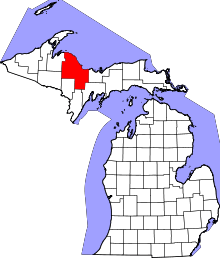 | |
| Charter townships | ||
| General law townships | ||
| CDPs | ||
| Other unincorporated communities | ||
| Indian reservation | ||
| Central cities | |
|---|---|
| Counties | |
| Geography | |
| Transportation | |
| Economy | |